eISSN: 2574-8092


Research Article Volume 11 Issue 3
Department of Radio Radioelectronic and Aerospace Systems, Azerbaijan Technical University, Azerbaijan
Correspondence: Bayram Ibrahimov, Department of Radioelectronic and Aerospace Systems, Azerbaijan Technical University, Baku, Azerbaijan
Received: October 21, 2025 | Published: November 27, 2025
Citation: Ibrahimov B, Mehdiyev A. Built on the base of a multicopter aviation platforms that are connected to the ground. Int Rob Auto J 2025;11(2):109-112. DOI: 10.15406/iratj.2025.11.00309
The efficiency and operating algorithms were analyzed built on the Base of a Multicopter Aviation Platforms that are Connected to the Ground. The article provides information about the mobile aviation platforms (MAPs) and Unmanned Flight Devices (UAVs) that are "suspended" by taking a ground-dependent flight status installed on the multicopter base, their various tasks performed, their characteristics and parameters, their relevance and importance.
Keywords: mobile aviation platforms, laser-guided devices, inertial navigation system, unmanned flight devices, ground-based multicopter
When we look at the recent history of the development of technology and technology, when we analyze the events taking place at the international level, we witness a very rapid change in the importance and development prospects of unmanned aerial vehicles (UAVs), and as proof of this, it is practically impossible to imagine modern armed conflicts and combatants today without UAVs.1,2
Today, in fact, most of the technical areas have been automated, making them robots with artificial intelligence, ensuring that they meet modern demands, while the rapid development in the field of UAVs continues to write a promising history, expanding their assignments and tasks almost immediately. An analysis of wars and conflicts conducted in a professional manner gives us reason to say that the party that gains altitude in the air on the battlefield-theater (DTM) is considered to be the main power holder or side.3,4
Real battles and conflicts are considered to be one of the main requirements of obtaining altitude in the air without human intervention and observing and making decisions about all its maneuvers without approaching enemy objects, which are carried out with the support of unmanned aerial vehicles (UAVs) on board more effectively and efficiently.
With this in mind, a high level of attention and financial assistance is being given to the creation and prospective development of new prototypes digital UAVs in developed countries to carry out combat and training tasks of the command at the DTM and training grounds. The main focus here is on monitoring the movements and maneuvers made by the opposite side in the DTM at any time of the day, analyzing its intentions and taking timely measures against it.
In this process, it is necessary to have a practically uninterrupted work regime during the duration of the battle, which practically makes it impossible for people to fully solve these problems without rest, and this ultimately leads to the emergence of certain problems in reality. At this time, it is practically impossible to provide reconnaissance information about the battle with the use of UAVs, almost uninterruptedly throughout the day, without providing food tension, making mistakes and losses.5,6
Therefore, it is considered appropriate to use mobile aviation platforms (multicopters) that remain "suspended" by taking the flight status of the ground dependent on the ground and the geographical relief of the ground and the conditions of installation in order to perform these and other types of combat missions at any time of the day without distortion and errors.3,7
General statement of the research problem
UAVs connected to the ground by a "fiber-optic cable" (fiber-optic cable) with this type of design are distinguishing from other types of UAVs in that they are fed from the ground by means of a cable-cable with above-ground control devices without food batteries on board, allowing them to operate smoothly and maintain the balance of the fuselage in the air, which is why such UAVs can remain suspended in the air for a long time, even for months.5,8
This device also has the ability to carry out stable information exchange with the ground control station and other objects in parallel with the tasks it can perform according to its intended purpose, and to lower and raise the device vertically, using a cable-cable (fiber-optic cable) and radio as a communication channel.9,10
Without an additional fuel supply and a food source of high volume or weight, it can be suspended in the air for a practical long time, it can descend and rise vertically along a line and the time spent on autonomous displacement is minimal, its construction is simple and inexpensive, the probability of the device (platform) falling into the hands of the enemy is minimized, the application of robotization complexes with the aim of increasing the efficiency of its parameters.11,12
They are considered to be different and superior features of mobile aviation platforms that are "suspended" by taking a ground-dependent flight status installed on a multicopter base (Figure 1).
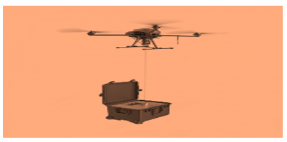
Figure 1 A mobile aviation platform that is "suspended" by taking a sky-dependent flight state connected to the ground mounted on a multicopter base.
Of course, depending on the purpose of each UAV, they operate in both the civilian and military spheres. However, in this article, we will try to focus our thoughts and directions on the UAV, which performs military missions, taking a suspended position in the air without interruption, staying in this state in the sky. The main reason for the importance of such multicopters is that they can partially replace the functions that artificial satellites and towers can perform, which are of great and strategic importance. In contrast to the Playner-type UAVs, multicopters are helicopter-type, and have the ability to remain "suspended" at any designated point in the air, they have a very large advantage and importance in some specific cases, and mainly in military fields.13,14
Thus, in practice, in cases where we are in trenches and specially guarded shelters at very close distances to the enemy against the background of complex geographical reliefs during the combat process, it is almost impossible to observe the opposite side, to correct rocket and artillery fire, to perform the function of a reconnaissance, to conduct reconnaissance and perform other tasks with a specific purpose, and in this case, in itself, it is impossible for us to explain the intentions of the enemy and to perform real tasks. It does not allow the enemy to control what is happening on the opposite side of the enemy's position.
In order to perform these works and all these other tasks mentioned above, multicopters, which are connected to the ground, that is, depending on the designated point of the mobile device on the ground, and practically act as a tower for us with this principle, can carry out reconnaissance or observation by masking against the background of any object and target, and can perform the function of pelengation.15
It can receive the enemy's radio calls and transmit it to the bull or to its own troops. On the opposite side, they are aircraft capable of communicating with the reconnaissance group and performing other tasks.6,16,17
Research components and structural diagram of the application of a ground-based multicopter
In modern times, the interest in multicopter type aircraft, the number of engines of which can be more than two, in accordance with the construction schemes of UAVs, continues to be constantly growing. A multicopter (twocopter, tripopter, quadcopter, gexacopter, octopter, etc.) is a multi-engine helicopter with a thrust principle.
In comparison with the aircraft-type UAVs, the specific features of multi-helicopters are that they have the ability to take off and land vertically in accordance with the helicopter flight principle without requiring a take-off and landing runway and expensive launch equipment. Robotic systems are installed on multicopters to perform various types of military and civilian tasks in accordance with their designs.
With the help of multicopters, it is possible to observe and reconnoitre objects in real time, or at the same time identify various objects, transmit the obtained data to ground control points, distribute targets (target aiming), direct guided projectiles and missiles to targets, determine and transmit coordinates, monitor the environment, take photographs, transmit radio signals over long distances, and It is possible to perform other specific combat tasks.9,10,12
In most cases, the set of equipment that performs these tasks is mobile, i.e. carried, so they are usually assembled on a car or trailer with a quadracoator complex and constructed on a mobile base. Drone UAVs are transported to the designated coordinates in these mobile complexes, lifted into the air and lowered to the ground by means special launching and lowering mechanisms.
The mobile mechanism should be equipped with holding mechanisms that connect the drone to the ground and provide it with food tension, breaking the cable-cable, and ensuring that it lands and landing.4,7,8,9
At present, they are in the process of developing UAV-multicopters, which are suspended in the sky by cable cables at the ground control station (UIM). The application of this system is considered promising mainly due to their small weight, size and energy supply characteristics, as well as the ability to remain suspended in the air for a long time at a specified altitude, the time spent on opening and the protection of transmitted data channels (having the ability to be hidden).
Sky-suspended multicopters (GAQMKs) include a launch platform, a base station, payload, cable-cable, above-ground food block, and other auxiliary elements that enable the launch of multicopters into the air (Figure 2). Here, depending on the combat mission, the payload is placed on a gyrostabilized suspension on the UAV, and they can consist of optical-electronic payloads and radar-electronic equipment and other devices for various purposes.5,7,8,14
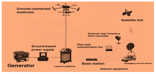
Figure 2 Components and application scheme of the Earth-bound multiocopter.
The production and development of place-bound multi-scooters mentioned in our article are engaged in the production and development of the most leading and developed countries in the world, including the United States, France, Israel, China, and other leading and developed countries. The designations, characteristics, and other specific parameters of the multicoters produced by these states may differ from each other. In this case, in most of such multicopters, taking into account the possibility of breaking the cable-cable, there is a reserve food block in their fuselages (bases) for safe automatic landing, they have an accident parachute and a catch and descent system, according to the report, the cable cable is thin as much as possible, the multicopper has the ability to track it during the movement of the mobile base at low speed, and One of the most important parameters of multicopters is the ability to change the speed of their engines, and the ability to remain stable in difficult weather conditions with a speed 35,…,50 km/h.
Since the supply of food tension to the cable from the ground is ensured, their face is dependent on the air for a period of time and performs their functions without interruption without changing the batteries, unlike conventional drones, they are more resistant to wind during complex weather conditions, the lifting load is high, the probability of detection is minimal, the visibility and command circle is increased by lifting it to a high altitude, the optical cable is connected to the optical cable in a stable form by the ground operator. Providing commands with the help of sensors, data exchange, and observational monitoring are considered to be the advantages of such a construction.6,9,14
The period of performance of the functions of mobile aviation platforms (UAVs), which are "suspended" by taking a flight position connected to the ground installed on the multicopter base, will be determined depending on the power of the ground power source of the UAV, the material and construction of the cable that transmits energy to the port, the weight of the payload and the reserve food block installed on board the UAV, and other auxiliary parameters.
The likelihood of a sustainable and uninterrupted supply of the food source will depend on its proper selection in accordance with the reports and the availability of the UAV on board and on the ground.4,7–9
As a result of the connection of the multi-nodes to the ground, at least three problems have been solved:
At this time, the detection and management of targets, target detection, control, distance, and altitude will vary depending on the location of the radar and the altitudes achieved by the UAV and the target.4,6,10 It is from this point of view that the location of ground-based detection drones in a high position (determining the distance in direct detection) will allow to detect enemy air targets from a greater distance (Figure 3).
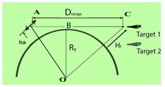
Figure 3 Depending on the altitude of the targets, the detection of air targets.
|
0.5 |
1 |
2 |
3 |
4 |
5 |
10 |
|
|
77 |
110 |
155 |
190 |
220 |
246 |
348 |
Direct visual distance (S) is calculated based on the radius of the earth (R) and the distance from the height of the object of observation to the horizon (h). Due to the refraction of radio waves in the atmosphere, this range for radio communication may be greater than that of optical communications.9
The following formula is used to calculate the visible distance up to the horizon:
Depending on the altitude, the distance along the horizon line is determined. Here, of course, one of the important conditions is to take into account the altitude of the ground-bound drone, the geographical relief of the ground, and the atmospheric conditions. In order to establish sustainable management under these conditions, the direct radio communication line and the distance between receivers or other antennas shall change in accordance with the law as follows:
With this point in mind, the UAVs, which are suspended from the sky attached to the ground installed on the multicopter base, will be able to visually and visually monitor and evaluate the real situation on the Battle-Theater Fields (DTM) by providing real security, directing aircraft, missiles and artillery shells to targets by means of radio signals, laser and optical-electronic guidance devices, informing and controlling troops It allows. An example of this is the combat control scheme of mobile aviation platforms that are "suspended" on a multicopter base (Figure 4).9,12
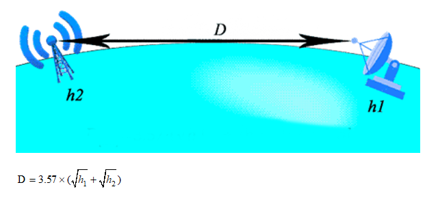
Figure 4 Depending on the altitude, the distance along the horizon line is determined.
Real-time positioning and navigation of the device is carried out with the help of the inertial navigation system installed on board the device, at which time the control is carried out by the operator controlling the UAV with the help of the control panel.
The radio communication and optical-electronics system installed in the multicopter allows to transmit the information obtained in real time to the Defense Department, aircraft performing combat missions, strike UAVs, missile-artillery launchers, as well as to various control bodies, and to direct weapons and ammunition to targets with the help of laser guidance devices and radar reconnaissance equipment.
An inertial navigation system is a high-precision navigation device built to accurately and accurately determine the positioning coordinates, speed, and orientation of the UA during the flight process in real time. Inertial navigation systems (INS) measure acceleration and angular velocity, and calculate orientation and navigation (Figure 5).
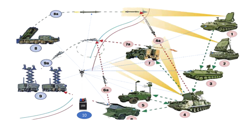
Figure 5 Battle control scheme of mobile aviation platforms that remain "suspended" on a multicopter base.
6a. Attack pattern of a UAV; 7. Air defense combat vehicle; 7a. Mobile surface-to-air missile launcher;
8.Ground-based artillery rocket launcher; 9.Ground control station; 9a.UAV; 10. Ground-based UAV
Built-in navigation algorithms make it possible to use INS in stabilization and monitoring, object orientation, course and coordinate detection systems at the same time when satellite communication is lost. The INS consists of a sensor that measures angular velocity, a linear velocity sensor, calculators, magnetometers, QPNS receivers, and barometers.
The Inns are in the Pacific. It is used in geosurveying, robotics, unmanned vehicles, railway vehicles, autonomous factory equipment and other facilities. Thus, due to the rapid development of UAVs, which pose a great threat not only to the troops, but also to economic facilities and infrastructure, the process searching for new methods warfare in the airspace abroad is underway.16,17
The successful development of modern technologies allows to conduct reconnaissance, monitor the battle-theater field or other spheres in various military formations, or in the State Border Service, the Ministry of Emergency Situations (DSS, the Ministry of Emergency Situations), the Ministry of Emergency Situations, Repeater and telecommunication communication systems that receive and amplify radio signals, as well as yeast systems that provide control, have also led to the practical development of small-sized and weighted UAVs that depend on the sky when they are dependent on the ground at low ground values.3,8,17
The article discusses UAVs (drones) that perform military missions by staying in the sky by taking a suspended position in the air without interruption, increasing the probability of their ability to partially replace the functions that artificial satellites and towers can perform, in cases where we are in trenches and specially guarded shelters at very close distances with the enemy against the background of complex geographical reliefs during the combat process.
For the purpose of long-distance observation, correction of missile and artillery fire, performing the function of a retransmitter, conducting reconnaissance and performing other special tasks, multicopters, which are connected to the ground, that is, depending on the designated point of the mobile device on the ground, and according to this principle, practically act as a tower, mask us against the background of any target and conduct reconnaissance or observation.
Information has been given about a flying aircraft capable of receiving enemy radio calls and transmitting them to the bull or to their own troops, providing communication with a reconnaissance group on the opposite side, and performing other tasks.
None.
Authors declares that there is no conflict of interest.

©2025 Ibrahimov, et al. This is an open access article distributed under the terms of the, which permits unrestricted use, distribution, and build upon your work non-commercially.