International Journal of
eISSN: 2576-4454


Review Article Volume 1 Issue 1
1Environmental studies department, the National Authority for Remote Sensing and Space Sciences (NARSS), Egypt
2Geology department, the National Authority for Remote Sensing and Space Sciences (NARSS), Egypt
Correspondence: Mohammed El Bastawesy, Environmental studies department, the National Authority for Remote Sensing and Space Sciences (NARSS), Egypt
Received: July 18, 2017 | Published: July 25, 2017
Citation: Bastawesy ME, Shalaby A, Mohamed I. Assessment of the hydrological and environmental problems of waste water disposal sites in aswan of egypt using remote sensing and GIS. Int J Hydro. 2017;1(1):17-23. DOI: 10.15406/ijh.2017.01.00004
This paper investigates the use of remote sensing and GIS for assessment of the hydrological problems of waste water in two key areas (Al Ballanah and Al Allaqi) in Aswan, Egypt. Basically, the waste water effluents are being pumped via pressure lines into the oxidation ponds and pools for the secondary treatment. The treatment sites of Al Ballanah and Al Allaqi are receiving annually 11.2 and 20 million cubic meters respectively, where the cultivation of woodlands are supposed to consume these water. Neglect of the hydrological and soil setting of these areas has led the insufficiency of available soil to support the required cultivation areas. The excess waste water has been impounded into retention pools that have been breached in September 2013 and April 2014 in Al Ballanah and Al Allaqi respectively and flash floods of waste water went to the Nile River. The water balance components for these systems were determined given the estimated areas for the cultivation and water ponds; the evapotranspiration rates and the estimated volumes of waste water being pumped to these sites. The estimated surpluses of waste water are 5.4 and 15 million cubic meters per annum for Al Ballanah and Al Allaqi respectively. The available soil in the first area is marginally capable and mainly located in upstream and distant areas from the main water ponds, thus additional lengthy branches of the pressure line are required. The available soil in the second area is located in a different wadi bed that can be also reached via a pressure line. However, the cultivation of this wadi bed requires the established of a dyke downstream to control any seepage from reaching Lake Nasser. Given the current difficulties to cultivate the required areas of available soil, the surplus accumulation of waste water can further be reduced via increasing evaporation rates from the water bodies through the introduction of voracious water crops such as water hyacinth. Additionally, these water plants will enhance the quality of waste water and could be used as raw materials for other purposes.
Keywords: Remote sensing, GIS, environment, Nile, waste water, cultivation
The management of water resources is a major challenge for most of the dryland countries, as the demands for water are increasing and the quality are being compromised due to a number of natural and economic factors.1,2 Basically, the understanding of natural hydrological setting requires lots of data measurements and abundant analyses, which are not available for the water-stressed dryland areas.3 This understanding is fundamental to properly assess the interaction water-use projects and the surrounding elements of the environment, to maximise the overall benefits from the limited valuable commodity in these areas.4 Generally speaking, the main water supplies for the dryland come from non-renewable groundwater aquifers, local marginal rainfall or far distant discharges from seasonal and perennial river systems. Recently, additional resources were added due to the development of several desalinisation plants in many areas, and the establishment of advanced treatment facilities that allow the re-use of waste water in specific activities. These non-conventional water resources are not widely available for most of the developed countries; therefore the hydrological stresses are increasing.5 These hydrological problems are of severe socio-economic and environmental consequences and include, but not limited to, shortage of fresh water supplies, waterlogging of urban and agricultural areas in the low land areas, and water quality degradation by the non-treated or non-managed waste water disposal. The safe disposal of waste water is one of the key issues facing several countries, as large quantities of municipal waste and industrial effluents are being produced due to increased urbanization and industrialization respectively.6 The major challenge is how to deal with the waste which is being released at a rate faster than its proper disposal.7 The exploration of freely available satellite images in google earth reveals serious development of these problems in many areas across Egypt and Saudi Arabia as an example Figure 1. The esitmated annual discharge of different treatment facilities across Saudi Arabia exceeded 700 million cubic meters, and approximately 200 million cubic meters of this water are being used for the different cultivation activities.8 Unfortunately, the delivered waste discharges to lower areas in the catchments via the usually dry-wadi beds have either developed perched water tables or being used by the locals in agricultural activities who are definitely non-aware of its devastating impact and fatalities. The long term use of wastewater in agricultural land is resulting in the contamination of soils by heavy metals. These heavy metals include zinc (Zn), cadmium (Cd), copper (Cu), and nickel (Ni), lead (Pb), manganese (Mn), iron (Fe), mercury (Hg) and chromium (Cr).4 The excess abundant of these traces is a main cause in plant intoxication, which eventually results in poisoning problems in human beings and animals. Therefore, irrigation with wastewater needs careful and planned management to ameliorate the negative impacts that may arise from reusing the improper treated waste in edible cultivations. Moreover, the seepage of this water into the underlying alluvium beds could percolate and replenish the wadi aquifer system, which could be used for irrigation of different crops. In Egypt, the problem of waste water discharges is alarming. All of the treated effluent from sanitation facilities of the Nile Delta is being disposed into the agricultural drains, which debouch into the northern lakes fringing the Mediterranean coast. Furthermore, several drains in the Nile Delta discharge into the main distributary river channels. Unfortunately, the disposal of waste water into drains of the Nile Valley region also finds its final way into the main Nile River or Rosetta branch. However, the fringing deserts on both sides of the Nile Valley have provided alternative disposal areas far from the Nile system. But the efficiency of adopted strategies of managing the treated effluent in the hinterland areas, are of high variability in different areas in Upper Egypt. These differences are related to the variation of landforms, soil development, geological and hydrological setting, and of course land use from one area to another. The hydrogeological evolution of Nile ancestors has fundamentally controlled the distribution of soils, and groundwater occurrences in these areas. For example, tens of meters thick clay and shale deposits of the Pliocene have filled the Nile graben, and can be found by shallow excavation in the fringing of modern Nile silt and clays.9 On the other hand, the Pleistocene sand deposits are stretching along the Nile flood plain in many other areas, and the Pliocene clays are simply absent in the near subsurface layers. These ancient deposits are occupying elevated areas relative to the modern Nile silts and clays, and the cultivation and urban encroachment to this arable soil have resulted in widespread waterlogging in some low land areas in the Nile Valley. Although, the selected sites for waste water disposal in Upper Egypt are located in far distant areas from the inhabited areas, but they still located within the tributary wadis to the Nile River. Therefore, the underlying hydrogeological setting governs the processes of water ponds development and/or the percolation to deep aquifer. Given these constraints the aim of this paper is to investigate the interaction of waste water management strategies, hydrogeological setting, and soil capabilities, in order to estimate the water balance of these areas. The development of undesired water ponds, shallow seepage pathways into the premises of these areas will be of profound negative environmental impact. The main objectives of this research are:
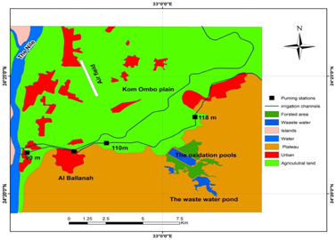
The study area: The waste water disposal sites in the Eastern Desert of Aswan are constructed into the narrow wadi beds dissecting the hillslopes of the basement and sedimentary rocks in Al Allaqi and Al Ballanah respectively Figure 1. The structures include large oxidation pools, which are build-up of concrete in Al Ballanah and of earth-fill dykes in Al Allaqi. The waste water is pumped via pressure lines to these areas, where the secondary treatment take place. The daily influxes are approximately 32 and 56 thousand cubic meters per day in Al Ballanah and Allaqi respectively. Originally, the waste water was conveyed to these remote sites to exploit the treated effluent in the cultivation of woodlands in the premises. The limited availability of arable soil has allowed the accumulation of waste water to reach the maximum storage capacity of the oxidation pools. Consequently, additional storage areas have been constructed upstream of the main pools in Al Ballanah in Wadi Al Rukbah, and into the tributary wadis of Al Allaqi using elevated earth-fill dykes. The accumulation of waste water has built small lakes that continued to grow and reached critical levels in short time. In September 2013, Al Ballanah dyke (6 m high) has collapsed probably due to the soil piping of the dyke materials, and the resulting flash flood has swept its way to a main irrigation channel and the attached agricultural areas, and it eventually reached the Nile River itself (Figure 2). The dyke was repaired and the new one is about two meters high than the previous dyke, as the impounded water submerged more marginal areas that were not inundated before. The limited availability of bare soil within Al Ballanah area is the key problem now. Furthermore, this soil of the wadi beds belongs to the Torriorthents (i.e. aridic soil with high moisture conditions or high soluble salt concentrations or both).10 Therefore, the capability is limited and the waterlogging development is common.
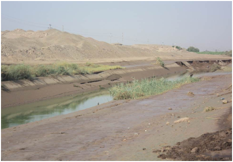
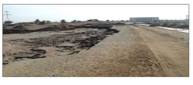
The problem of waste water in Al Allaqi area is more or less similar to Al Ballanah, but the oxidation pools and ponds are distributed over large areas belonging to different wadi systems of the Nile and Lake Nasser. The oxidation ponds were also breached in April 2014, but fortunately the torrential flows were contained by a dyke on the main wadi bed downstream of the oxidation pools Figure 3. Herein, the alluvium soil is composed of coarse gravel and sand, which are derived from the surrounding basement rocks by the weathering processes. However the study area is located within the hyper-arid climatic regime; Precipitation is very rare, and several years may pass without any record of rainfall (e.g. 1979–1986). But high-magnitude storms are not uncommon, e.g. a total rainfall of 92 mm in 2 days during October 1987 was recorded in Aswan area.2 Therefore, the flash floods could add additional overburden on these sites. This area is also characterized by very hot summers and relatively cold winters and the air temperature ranges in summer between 49.5_C and 27.3_C and in winter between 30_C and 15_C, while relative humidity ranges between 43% and 18% in summer and between 43% and 10% in winter.11Meteorological measurements taken within the Lake Nasser area to the south of Al Ballana showed that the monthly mean of relative humidity ranges between 32% and 58%. The monthly average of the rate of evaporation, as measured during the period 2003– 2005, reached between 115 mm in winter and 300 mm in summer with an overall average of 2000 mm per year.12 These preliminary climatic indices will be considered in the assessment of water balance.
The waste water management in the study area has been complicated by the current land use, the hydrological setting and soil availability and capability. The quantities estimates for these different controlling factors have been derived from multitude of remote sensing data, DEM, and field survey given the following detailed data sources and methods of processing techniques.
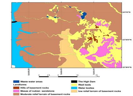
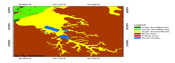
Firstly, the Landsat satellite images (Path 174/ Row 43 and 174/44) available from The Earth Observation Data Centre (EROS, http://glovis.usgs.gov/), were downloaded to analyze the landuse and landcover changes for the area, as well as delineating the alluvium soil of wadi beds (Figure 4). Following the image-quality guidelines of the USGS images with a quality code of 9 were selected. The Landsat images have been used after performing several steps of image pre-processing and enhancement. Pre-processing of the images involved image co-registration, normalization, edge detection and histogram equalization.5The water bodies and other land use classes were delineated by the digitization process. The landforms dominating the study areas were also mapped using the processes satellite images and the other thematic maps available (Figure 5). The soil map of the study area was extracted from the available soil map of Egypt produced by the Academy of Scientific Research and Technology;10 the original nomenclature of soil order, suborders and great groups has been updated according to the latest American Soil Taxonomy of.13 The transformation of the soil map into a digital format was done (Figure 6). The land capability classes were obtained using soil data following the methodology of.14
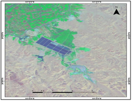
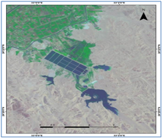
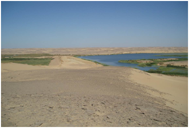
Secondly, the DEM of the Shuttle Radar Topography Mission (SRTM) was downloaded from (EROS, http://glovis.usgs.gov/) to automatically extract the drainage network and drainage basins hydrographic parameters using the ArcGIS 9.3 software. The original SRTM data can contain some local areas with unregistered elevation data, particularly in areas covered by sand dune. Therefore, the pre-processing was necessary to assign an elevation value for each of those pixels whose elevations are missing. This step was carried out using the logical and mathematical functions within GIS. Then the DEM was ‘filled’ in order to adjust values of the artifacts to their neighbouring pixels, to ensure the connectivity of extracted drainage networks in the downstream direction.15 The extracted drainage networks from the DEM required the calculation of ‘flow direction’ from the ‘filled’ DEM, and the calculated’ flow accumulation’ from the ‘flow direction’ grid.16 The resulting drainage networks and associated sub-catchments were overlaid on the satellite images to check that the matching with visible wadis and streams.17 This comparison is necessary to ensure the accuracy of DEM in simulating the topographic relief and thus, the resulting lake shapes and geometry at various levels.18 These derivatives are necessary to identify the areas prone to the seepage and flooding from the stored waste water upstream. These sites were visited in the field to verify the observations and derivatives of the remote sensing and DEM data sets. The earth-fill dyke in Al Ballanah is composed of sandy shale fragments that have been grouted from the surrounding plateau. The engineering design data for this structure is not available, but the old dyke was reinforced after the collapse and the new dimensions are 420 m, 60 m and 9 m in length, width and height respectively (Figure 7). Castor oil is the main cultivation in this area, and the waterlogged areas are covered by dense shrubs and reeds. The oxidation pools of Al Allaqi are built of interconnected banks and the individual basins are rectangular and measure 290 m, 140 m, and 1.5 m in length, width and depth. These basins were empty during the field visit and the surrounding cultivation is dominated by the oil-producing plants such as castor oil. Some of the water is currently pumped to other storage areas in the tributary wadis of Lake Nasser, and the rest of it is being disposed into a drain designed to convey the flash floods into the Nile.
Overall, the obtained data from these multiple sources were integrated into GIS to estimate the surface areas of water bodies and the annual evapotranspiration amounts using the estimates from neighboring Lake Nasser and Tushka. The annual water consumption depth of 1900 mm19 for the castor oil is used to estimate the annual water budget that can be used when the additional cultivations are added in the bare soil areas. The annual surplus amounts of water can then be estimated. Finally, additional areas for water storage and cultivation are introduced to ensure the full consumption of waste water and to control the problem of seepage into the Nile Valley and Lake Nasser.
Disasters of the waste flooding from Al-Ballanah and Al Allaqi areas indicated that the currently adopted management strategies are not adequate. Therefore, the hydrogeological and soil characteristics of the sites allocated for waste water treatment and re-use have been investigated, and the annual water balance were estimated. Approximately 32000 cubic meters of sewage water are being pumped every day to the treatment facilities and the oxidation pools in Al Ballanah which covers approximately 1km2 and already reached its maximum storage capacity. Pressure lines are being utilized to transfer surplus of waste water to two additional storage ponds erected on the tributary wadis to the oxidation pool. The largest one reached 1.1Km2, before the collapse in September 2013. The analysis of DEM (i.e. height of water column of each pixel) captured before the partial filling of pond area, showed that the stored volume was Approximately 4.5 million cubic meters. The most recent satellite image of January 2017 shows that the area has reached 1.5km2 due to the reinforcement to the width and height of the dyke. The cultivated woodland area approximately covers 140 ha. The annual average evaporation from open water bodies (the oxidation pools and waste water small ponds and lakes), and applied irrigation to the woodlands are estimated to 5 and 1.1 million cubic meters respectively. These results suggest that only 6.2 million cubic meters of water are annually consumed in the area out of 11.6 million cubic meters being pumped into it. The surplus annual accumulation of 5.4 million cubic meters is really adding more pressure on the existing structures and the repetition of September 2013 disaster will be catastrophic. This surplus amount of water requires at least an additional 700 h for castor oil cultivation or similar crop. However, the soil and landcover maps show that some 3000 h of Torriorthents sub-great group is available. But most of it is available in the wadis floors either upslope of Al Ballanah small lake or in distant areas being separated by the hillslopes of the. Plateau. The reaching of these separated parcels require the construction of additional branches of the main pressure line feeding Al Ballanah small lake, and the cost of these installation is a main challenge. Furthermore, the potential of these soil is limited due to several factors including the slope, shallow depths, the susceptibility to erosion, and the unfavorable soil structure and the moderate correctable salinity, which support the development of water logging and salinization problems. Therefore, these soils require considerable management inputs, but even so, choice of crops or cropping systems remains restricted because of inherent limiting factors. The slope of the study area varies from 0 to 16 percent. These slopes were categorized into four classes according to the FAO’s 1985 land evaluation for irrigated agriculture. The first class ranges from 0 to 2% and covers 32% of the total available soils. The second class has slopes ranges from 2 to 4% and covers 22 percent of the soils. The third class falls within slopes from 4 to 8% and cover 24 percent of the soil. The fourth class of slopes exceeds 8% and covers 22 percent of the study area. This means that only 554 ha of the soils have a slope of less than 4% and hence suitable for cultivation. The area of Al Allaqi contains only 680 ha of alluvium soil that are being used mainly for water storage and partially for cultivation. The annual waste water budget is approximately 20 million cubic meters and the surplus amount reaches 15 million cubic meters per year. That why most of these water are currently being diverted into a drain "Al Sail Drain" that ends into the Nile River. Because the area is underlain by basement rocks and Nubian sandstone, the alluvium of wadi beds are composed mainly of coarse gravel and sand and subordinate clays. The slopes, texture, depths and surface extent are of better conditions than in Al Ballanah. Herein a pressure line of 6.5 km length is suggested to convey the water from the site of oxidation pools to a new area (i.e. Wadi bed) that contains 2200 ha of alluvium soil. However this wadi ends into Lake Nasser, but its downstream part is gorged by high relief shoulders of the basement rocks, therefore a control dam can be constructed downstream at the gorge site to prevent any seepage from the cultivation up slopes to reach the lake (Figure 8).
The waste water ponds are notably expanding in the hinterland of the Nile Valley due to the non-adequacy of the management strategies to safely re-use the treated effluent in the cultivation of suitable crops. The hydrological data of these effluents are frankly non-available and the responsible organizations are very strict about releasing data that could indicate any negative signs on the treatment of waste water projects. In fact, the site selections were not preceded by detailed hydrogeological and soil assessment. The problems of ponding and seepage of waste water is nearly present in most of the sites allocated for waste water treatment and cultivation of attached woodlands. The hydrogeological setting 9,20,21 controls the seepage pathways, soil development and infiltration magnitudes into the underlying alluvium soil. The geological maps of Egypt show that the wadis outlets into the Nile River are underlain by Pliocene shale deposits which indeed preclude the infiltration to deeper depths, and augment the development of ponding and waterlogging near the surface.22 These clay deposits are the main source materials for the brick and cement industry in Egypt, therefore numerous quarrying depressions are dotting the hinterland of the Nile Valley. The construction of oxidation pools in the wadi courses upstream of some of these depressions has resulted in the development of huge water ponds such as in Al Saaf area in Giza Governorate. These hydrogeological problems are further complicated by the flash floods as the catchment areas affecting the waste water sites can reach up to few hundreds of square kilometers, and the mitigation measures for flash floods are generally absent for most of the wadis. Again, the quality and accuracy of hydrological analyses are also affected by the absence of detailed climatic data that impose strong control on the runoff potentials, evapo-transpirations, hence the water-balance results. The high resolution topographic data on these sites are also not available, therefore the use of the SRTM DEM with 90 m cell resolution certainly introduce a great deal of uncertainty in estimating the storage volumes of the waste water ponds and depressions. The elevations of each individual cell in the SRTM matrix are given in integers, and the approximation of fractions can lead to huge differences in the total depths particularly in small ponds. However, the use of SRTM data was beneficial as it allows the extraction of drainage networks both upstream and downstream of these sites. Therefore, the vulnerable areas to seepage and perched water table development were determined. The land use and land cover analyses of remote sensing data along with the landforms expressions from the DEM have helped in the identification of potential areas in the vicinity of Al Allaqi site that can be exploited for the required woodland cultivations to alleviate the Nile River in Aswan from receiving the waste water from "Al Sail Drain". Of course a detailed feasibility study is needed and the cultivation of nearly 2000 ha woodland can be of socio-economic benefits if properly managed. Although, the direct benefit of better managing the waste water sites is the overall enhancement of the local and the regional degraded environmental parameters. However huge amounts of the waste water are being contained within Al Ballanah area, the environmental implications is as serious as in Al Allaqi. This is because the destructive flash floods of the waste water eventually reach the Nile after contaminating the agricultural fields in its way downstream. Additionally, some of the surrounding agricultural fields to these sites are being cultivated by different crops from this waste water. The limited availability of capable soil is leading again to the accumulation of waste water at even larger scale than that of September 2013. Herein, the aquatic plants, such as water hyacinth (Eichhornia crassipes), pennywort (Hydrocotyle umbellate), and duckweeds (Lemna spec.) can be introduced into the existing water ponds to increase the consumption of water via evapotranspiration.23 indicated that evapotranspiration from water hyacinth can exceed open-water evaporation rates by a factor of ten in some areas. Moreover, water hyacinth has the potential to clean up various contaminated waters.24 In the meantime water hyacinth will remove excess water due to its high evapotranspiration. Water hyacinth was found capable to remove pollutants from wastewater.25 Finally, the bye-products of wastewater treatment; harvested water hyacinth plants and sludge, could find applications in agriculture, as raw materials, replacement for construction materials and as energy sources.
The waste water of two key sites in Aswan are being disposed of into large oxidation pools in the hinterland of the Nile Valley, where it supposed to be used in the woodland cultivations. Overall, the waste water has been gradually accumulated as the losses of effluent via evaporation and cultivation are much less than quantities delivered to the treatment facilities. The torrential flooding of waste water from a retention dyke in Al Ballanah in September 2013 was of severe environmental consequences. The problem of accumulation of surplus water is even growing, and the cultivation of additional woodlands is definitely needed. The introduction of aquatic plants to the water ponds can help increasing the water losses via evapotranspiration. The oxidation pools in Al Allaqi site were also breached in April 2014, and most of the treated waste water are being discharged back into the Nile via the flash flood drain known as "Al Sail Drain". Alternative areas for woodland cultivations have been suggested to ensure the full consumption of the waste water introduced into Al Allaqi area. The wider implications of this research provide the integrated approach of remote sensing and GIS data to:
None
None.

©2017 Bastawesy, et al. This is an open access article distributed under the terms of the, which permits unrestricted use, distribution, and build upon your work non-commercially.