MOJ
eISSN: 2572-8520


Research Article Volume 2 Issue 3
Department of Geosciences, Federal University of Technology, Nigeria
Correspondence: Nwachukwu MA, Associate professor, Department of Geosciences, Federal University of Technology Owerri, Nigeria
Received: January 14, 2017 | Published: March 14, 2017
Citation: Nwachukwu MA, Nwachukwu MI, Ahiarakwem CO, et al. Abandoned borrow pits; risk factors and reclamation procedure. MOJ Civil Eng. 2017;2(3):88-95. DOI: 10.15406/mojce.2017.02.00033
Abandoned borrow pits and the associated risks are on the increase following rising trend in road construction in many developing countries. Notable risk factors include: frequent sliding, loss of life and ecosystem services, groundwater contamination, and loss of arable land. Reclamation of borrow pits should go by earth-moving; moving spoil heap and adjoining land area to fill the pit. This is followed by compaction and in-situ and laboratory testing to achieve the original geotechnical ground condition. Operators, host community and the government agency must agree and enforce reclamation of borrow pits soon after use. Borrow pits should be properly sited, planned and designed by professionals, with provision of appropriate safety measures. Reclaiming a borrow pit should be as important as opening a borrow pit, towards sustainable engineering and environment.
Keywords: soil excavation, road construction, environmental hazards, soil tests, geophysics, safety, sustainability
In this study, selected borrow pits around Owerri, South-eastern, Nigeria were investigated (Figures 1A & 1B). These borrow pits were originally established as source of road fill material. The ARAB contractors borrow pit is active, and serving the dualization of Owerri-Port-Harcourt highway. The borrow pit at Emekuku is still active, originally served for the construction of Owerri-Umuahia highway, and is presently the source of red earth material to nearby construction sites. The Ogbulubi borrow pit was established during the construction of Owerri-Okigwe highway, became abandoned, but is presently activated as source of earth fill material to road projects within Owerri. The borrow pit at Iho originally supplied earth fill material for the construction of Iho-Ogwa road. It is presently abandoned, and used for waste dumping. The borrow pit at Avu, originally established during construction of Owerri-Port Harcourt road became Owerri urban waste dump for years, and now filled and abandoned. The random establishment of borrow pits for highway construction and other civil engineering work without the intention of restoring or reclaiming the sites after use, has left much to be desired in terms of the potential hazards. There are hundreds of other abandoned borrow pits scattered in South-eastern Nigeria and all over the country. Clearing of vegetation for borrow pits and not restoring it to its original states is a distortion of ecosystem which can lead to the extinction of fauna and flora species.

Figure 1A Map of Nigeria showing the study area.
Figure 1B Project map of study area, showing location of borrow pits investigated.
Some of these borrow pits have lived for decades, with abandonments and later reactivation for the earth material to be used in another location. With increasing population and improvement of road infrastructure in many developing countries, there are many active and abandoned borrow pits all over the place. Several acres of land are degraded by abandoned borrow pits turned ponds or waste dumping sites. In this study area, Ihiagwa and Emekuku borrow pits as the largest, yet the pits are neither planned nor designed professionally. The operators of borrow pits engaged in unsustainable engineering practice, leaving the environment unsafe for human dwelling and ecosystem services over years. This situation has led to several potential environmental and geo-environmental hazards which are visible in highway failures, landslides, erosion, surface and groundwater contamination, accident to man and other roaming animals, thereby threatens biodiversity. It is therefore of great necessity to investigate environmental risk factors of abandoned borrow pits and foster the idea of site reclamation and restoration soon after the borrow pit operation is concluded.
The area is underlain by the Benin Formation; this formation which is Pliocene to Miocene in age consists of coastal plain sands with minor clay beds. The borrow material, being lateritic soil or red earth, constitutes the overburden, followed by the Benin sand. The formation contains some isolated gravels, conglomerates, and very coarse sandstone in some places. The mean thickness of the Formation in the study area is about 800m while the mean depth to water table is about 18.3m1 confirmed that the Benin Formation is overlain by alluvium deposits and underlain by Ogwashi-Asaba Formation which consists of lignite, sandstones, clays and shale. The Benin Formation provides the aquifer for groundwater storage because of its high porosity and permeability. The incidence of high porosity and permeability as well as shallow water table makes the groundwater in the area very vulnerable to pollution. The geologic setting of the area, therefore, calls for proper land use and waste management practices so as to protect the soil and water resources of the area. The borrow pits investigated are found to be within the Benin Formation as shown in the Geologic map of Imo River Basin (Figure 2).

Figure 2 Geologic Map of Imo River basin, showing the Study Area.2
Laterite soil which is the product of borrow pit excavation in the study area is used as a sub base and base course for construction of highways and embankments.3 Laterite consists mainly of the mineral kaolinite, goethite, muscovite and gibbsite which form in the course of weathering. Only those weathering products that are geochemically, mineralogical and most strongly altered are defined as laterite.4 In countries of the tropics and sub-Sahara, laterite soil is encountered in various engineering projects. In Nigeria, uplifted continental land mass made up of basement sediment resulted in the formation of laterite soils which are of relatively good quality for road construction work.4 However, most of the laterite soils used in the construction of many Nigeria roads is gotten from pits without geotechnical study to determine their suitability as road fill material. This has consequently led to the loss of productive time on the highway, loss of life and properties, and finally to the repeated contracts of repairing roads instead of channelling such fund to other sectors of the economy. The use of geophysical method such as Vertical Electrical Sounding (VES) in the investigation of borrow pit site will minimize the trial pit methods that have left behind abandoned pits.5 The presence of such small trial pits has led to several pits littering the study area. Although the area disturbed by a single excavation operation generally might be small, the combined acreage in the area is substantial.
Some abandoned borrow pits are threats to public safety due to their dangerous vertical walls that are prone to landslides after heavy rains that enhance saturation and liquefaction. In some places, abandoned borrow pits are filled with runoff water from adjoining lands to become ponds. More often children use the ponds as swimming pools, and many drown in the process.5 Borrow pits containing stagnant water also become breeding ground for vectors like mosquito and tsetse fly. Often abandoned borrow pits not containing water serve as dump sites of “end of live” vehicles. They can also be used for illegal dumping of urban wastes, and hide-out for armed robbers and ritual killers. When these situations arise close to residential areas, more socio-environmental problems confront residents.
Omosanya KO6 recommended that a detailed environmental impact assessment be carried out before a borrow pit license can be obtained from the government. According to them, a task force should be set up by government to indict operators and contractors that do not comply with borrow pit excavation regulations. Pistocchi A,7 said that early response to the issue of abandoned borrow pits is to characterize the special features of the effects of unsustainable excavation. Both active and non-active borrow pits should have proper health, safety and environmental policies properly spelt out.5,8 Historically, many roads or highways were simply recognized routes that had no formal construction or maintenance.9 Highway or road construction process often begins with the excavation of red earth and rock used as road-fill material often beside the road under construction. It includes construction of embankments, bridges and tunnels and removal of vegetation followed by the laying of pavement material. A variety of road building equipment like bulldozer, grader and trucks are employed in road construction.10 After design, approval, planning, legal and environmental consideration have been addressed, alignment of the road is set out by surveyors. According to,11 the gradient and radii are designed and staked out to best suit the natural ground levels and minimize the amount of cut and fill. Care is taken to preserve reference benchmarks, using erosion sediment controls to prevent detrimental effects. The process of earthwork includes excavation, removal of material to spoil, filling, compacting, construction and trimming of rock or other unsuitable materials. Moisture content is managed and replaced with standard fill compacted to 90% compaction.12
Generally, fill materials should be free of organics, meet minimum California Bearing Ratio (CBR) and have acceptable plasticity index. The lower fill comprises sand or sand rich mixture with gravel which acts as an inhibitor to the growth of plants or other vegetable matter.13 Careful excavation and design of borrow pit slope can reduce landslide accidents. Deep borrow pits often with negative slope support frequent landslides. Landslide is a geological phenomenon which occurs as a result of ground-water movement and is common in large abandoned and active borrow pits. It can occur as rock fall, failure of unstable slopes, and debris flows on slope.14 Many different triggers cause landslides. They include intense or prolonged rainfall, earthquakes, poor design of mine pits, and snow melting,15 the volume of mass movements spans fifteen orders of magnitude, and landslide velocity extends over fourteen orders of magnitude, from millimetres per year to hundreds of kilometres per hour. Despite information contained in landslide inventory maps, very few attempts have been made to assess their reliability. Ardizzone15 also stated that landslide identification needs to be carried out by experienced geomorphologists.
Akpokodje EC & Hudec PP16,17 observed that the cleaner, more porous and weakly cemented sands of an abandoned pit are the most prone to initiate erosion and landslide. Considering this input,18 concluded that community-based low-technology land management practices and public awareness programs through workshops could halt the development of many gullies from abandoned borrow pits. Human activities that trigger erosion such as roadside excavation, abandoned borrow pits, and roadside waste disposal must not be allowed. In this case, there is need to intensify effort towards sustainability studies on these vices that may trigger gully erosion, and report findings to the public through sustainability seminars 19 recognized geological and geotechnical parameters as main causative agents in the formation of gullies. The varying opinions of these researchers become significant from one location to another. For example, environmental problems of abandoned borrow pits in the tropical rain forest belt of study area are due to high rainfall intensity. Troeh FR & Fiener P.20,21 have described amount of precipitation, energy and intensity of rainfall as the major physical factors contributing to the risks associated with abandoned borrow pits.
Four borrow pit sites were identified as shown in Figure 1B: Ihiagwa, Emekuku, Ogbulubi and Iho. Ihiagwa and Emekuku were deeply investigated by direct measurements and use of photographs. Geophysical technique by electrical resistivity method was used to determine depth of the lateritic topsoil in each of the sites. The elevations and coordinates of the pits were measured with E-Trex Geographic Positioning System (GPS) and recorded in a spread sheet. Pit geometry, including angle of slope and recent sliding surface, overburden, and depth of red earth were duly measured and recorded. Potential hazards and environmental impacts of both the abandoned and the active pits were assessed. Ihiagwa pit was established by ARAB contractors for the dualization of Owerri to Port Harcourt highway. Emekuku pit earlier established for the construction of Owerri to Umuahia highway is now used as source of laterite for several engineering projects.
Hand auger was used for the collection of composite samples from Emekuku and Ihiagwa pits and tested, to ascertain the geotechnical properties of the lateritic soil. Their economic importance was investigated and compared with the prevailing environmental degradation to obtain a cost benefit analysis. In each pit, three replicate samples were collected and properly homogenized to make one composite sample. The two composite samples (one from Ihiagwa and the other from Emekuku were subjected to the following tests:
Field coordinate data were converted from degrees, minutes and seconds to digital coordinate values and then transformed to Geographic Information System (GIS) map using ArcGIS 10.1. Elevation data obtained were also applied to the ArcGIS software to obtain a topographic map of the study area (Figure 3). Electrical resistivity data were subjected to Advanced Geosciences Incorporation (AGI) 1D inversion technique analytical software was used for processing. Geotechnical data, Microsoft Excel 2007 software was used to plot the graphs. The environmental field assessment and the analytical results became integrated, such that a comparative analysis of the Ihiagwa and the Emekuku borrow pit sites was carried out. Integrating the Ihiagwa and Emekuku site conditions with the field assessment of Obulubi and Iho sites, brought about a detailed geo-environmental assessment of borrow pit activities in the project area.
Environmental field measurements and risk assessment
Borrow pits located near settlements are a source of concern in terms of human health and safety. Such borrow pits could become breeding areas for mosquitoes during the rainy season should they become inundated with water. Other health and safety concerns could be to children who may use the collected water as play grounds and contact water borne diseases such as bilharzias or possibly drown. All the borrow pits were found too close to the roads such that they are a danger and could cause accidents to the motoring public (Figure 3A & 3B). In the four abandoned pits investigated, they presented a situation of unsustainable engineering practice. The areas under study are classified as degraded land and danger zones where no meaningful agricultural activities can be carried out. The animal and plant species within this area are threatened and are likely to face extinction due to the destruction of their habitat. The areas are characterized by thick and dense vegetation typical of the tropical rainforest.
The soil is mostly sandy and gravel-like. The presence of trees, shrubs and grasses is responsible for the dense vegetation within the areas. The topsoil, less than 1 m thick, consists of dark humus soil for agriculture. This top soil is followed by the reddish lateritic soil which constitutes the borrow material. Thickness of this red earth or the borrow material as measured in the Emekuku and Ihiagwa pits (Figure 4A) varies between 8m and 11m, and may often have sand lens at some locations. The borrow material was observed to be underlain by sand and gravel beds. The sand and gravel beds may conduct groundwater, causing pockets of ponds in the pits (Figure 4B). Excavation of the water saturated sand and gravel beds for building and other engineering projects other than road, triggers erosion, form cavities or causes landslides (Figure 4C).
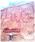
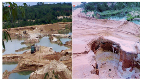
Figure 4A Field measurement of pit depth and slope (Left), 4B: Pit excavation causing pocket of pond (Centre) and 4C: Pit excavation causing dangerous landscape, destroy access road (Right).
Field measurement and assessment
Figures 4-7 are photos illustrating present site conditions. In the two sites visited there were issues of landslide as a serious environmental problem in the area. Landslide which is described as a down slope movement of rock and soil along slip surfaces is also associated with disturbance of the equilibrium which normally exists between stress and strain in material resting on slope. This relationship is dependent on factors like height, steepness of the slope, density and strength (cohesion and friction) of the material on the slope. The geometry of the two sites (Ihiagwa and Emekuku) revealed a slope angle of between 700 and 800. The slopes were compromised during the excavation process. Also the pit slope has been weakened due to heavy rainfall common to the area from March to September. The resultant effect of landslide in the area has led to loss of lives and damage to properties. Community personnel interviewed affirmed that abandoned borrow pits cause the community un-quantified loss of properties. From the vertical electrical sounding carried out, the study area subsurface is predominantly sandy resulting in high permeability and frequent mass movement of the soil in the pit wall. Active fresh slumping and sliding surfaces of the lateritic soil (Figure 5A & 5B) are common features of an abandoned borrow pit. Sliding of the lateritic face goes on with falling of trees (Figure 5B) due to exceeding overburden pressure and unstable pit slope angle. Often this results in accidents, loss of life and destruction of excavators (Figure 5C).
Soon after, abandoned borrow pits in the area could turn to marsh land or swamp (Figure 6A) or turn into pond (Figure 6B). This situation reduces environmental quality by breeding of mosquitoes and polluting the groundwater. Often there is loss of life as children swim or fetch water from the pond. Prevalence of tension cracks on abandoned pits (Figure 6C) and mud cracks on dried marsh land in the area (Figure 6D) also facilitate infiltration and transport of pollutants to groundwater. Surface instability may occur when the material is stressed to its strength limit, thus causing fracture or excessive deformation. Overburden stress, rainfall intensity and water saturation are key factors that initiate pit slope failure. This situation reduces cohesion and sets up a plane of failure, which becomes a sliding surface as soon as the shear strength is exceeded.

Figure 5A Abandoned borrow pit showing old slide surface and recent slumping (Left).
5B: Active borrow pit with rapid sliding of palm trees into the pit (Centre). 5C: Heavy duty excavator at work, often affected by sliding (Right). Images created by M. I. Nwachukwu.

Figure 6A Borrow pit turned swamp; 6B: Borrow pit turned pond; 6C: Borrow pit wall with tension cracks; 6D: Borrow pit floor with mud cracks.
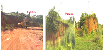
Figure 7A Borrow pit operation threatens collapse of family duplex and fence (Left).
7B: Borrow pit threaten high tension power pole (Right). Images created by M. I. Nwachukwu.
Borrow pits threaten structures
At Ogbulubi borrow pit site, about 20m from the edge of the abandoned borrow pit, is a fence and one-story building under threat of sliding (Figure 7A). Because of the fact that heavy duty equipment like bulldozers, pay loader and trucks were used for excavation and loading of the laterite soil to designated construction sites, the equipment have the tendency of causing vibration that sends lateral waves to the surrounding structures which also weaken the foundation of the structures and cause displacement. During the rainy season, the micro cracks created will become water infiltration pathways and finally produce mega cracks that will cause pit slope failure. Incidents of slope failure causing sliding could cause collapse of structures such as buildings, roads and drainage system, certainly causing huge economic loss to the owners. On top of one of the abandoned borrow pits at Owerri-Okigwe highway is a high tension electric pole (Figure 7B). From the edge of the pit to the high tension pole is about a distance of 15 m. There is a thick vegetation cover of India bamboo which tends to stabilize the soil, but that cannot prevent sliding soon as it is initiated. The high tension pole poses a lot of threat to the residents and commuters plying that route. The economic and social risks associated with the situation of these high tensions power poles are enormous and should not be compromised.
Factors causing sliding at the Pits
The classical approach used in designing open pit excavation is not applied in the study area. There is no benching or pit bench design; rather there is continuous excavation in a single bench (Figure 8). That implies no proper consideration to safety and possibility of sliding in the pits investigated. Critically, there is no consideration to the relationship between forces resisting sliding (Bf) associated with the sliding base distance (B).
Probability of sliding: Figure 8 show force resisting sliding (C) possessed by the base rock and the overburden pressure (D) initiating sliding. The Factor of Safety (F) of the pits is defined as
F = C/D, and sliding is assumed to occur when F is less than unity. For assurance of safety, C must be greater or at least equal to D. F is controlled by the following factors:
Type of rock material constituting the overburden (Unit weight of rock)
Presence of trees increasing overburden pressure or tension
Presence of external force such as buildings, machineries, vibration or seismic waves increasing tension
Degree of water saturation (Unit weight of water)
H = Effective Depth, W = Width, α = Angle of slope after treatment (60-75 degrees),
β = Angle of slope before treatment 75-90 degrees), X1 = Pit wall before treatment,
X2 = Pit wall after treatment, C = Force resisting sliding, D = Overburden pressure
SS = Possible sliding surface or the excavated treated surface
If α = Sliding angle increases, D reduces, thereby increasing safety factor, and reducing the probability of sliding. Other conditions are as follows:
SS = Sliding surface; established by tension crack is enhanced by water saturation, thereby increasing probability of sliding. This surface should be sliced as a treatment to the pit wall to increase slope stability at the landfill.
α= Pit slope angle when reduced, enhances slope stability
H = Effective depth of pit affects pit slope angle and stability of slope
Geotechnical characteristics of the borrow material
For effective reclamation of a borrow pit, the original properties of the soil must be determined and technically applied in the reclamation process. Most important parameters include: Grain size distribution, Moisture content, Density, Shear strength and Bearing capacity. Laboratory tests on soil samples obtained from the pits under investigation show grain size ranges from very fine to very coarse, with significant clay silt content (Figure 9A & 9B).This implies that the lateritic soil is plastic, can be generally described as cohesive, and suitable as road fill material for which it is being used. A maximum dry density (MDD) range of 1.84 to 1.93 mg/m3 was measured at the two sites, with optimum moisture content (OMC) of 13.9% for Ihiagwa and 14.3% for Emekuku (Figure 10A & 10B). Of the two samples tested, plasticity index (Ip) of 18.2% and 21.2% were obtained for the Ihiagwa and Emekuku samples respectively (Figure 11A & 11B). Shear strength of 99.6 KN/m2 was obtained for Ihiagwa sample and 95.7 KN/m2 for Emekuku sample with angles of internal friction of 27 and 26 degrees, respectively (Figure 12A & 12B). These values are significant to be considered when using the soil for road fill material and during reclamation.
The resistivity measurement of the Emekuku study site also shows that the area consists predominantly of sand- sandstone after the topsoil and the lateritic soil overburden. The sandstone starts at a depth of 30.89m and persists to a depth of 165m (Table 2). Similar to the Ihiagwa area, the lateritic soil occupied depths between 0.5 to 19m (Average thickness of 18.5m). This thickness is significant for borrow pit development. The soil is adequate for road fill while the sand and gravel are good for block work; concrete etc., following ASTM and British Standard for road fill and embankment construction. Depth to water table at the two sites was mapped out and identified as shallow. A water table depth of 40.43 m was found at Ihiagwa, and at Emekuku, the water table fluctuates between 47.78m. In the presence of borrow pits with depths up to 20m at some locations; contaminants from drainage collection into the pits could migrate easily to the water table, thereby contaminating the groundwater. It is important to note that the two communities housing the investigated borrow pits depend on groundwater obtained from shallow wells for their drinking and other domestic uses. These shallow wells have average depth of 44 m, and according to,22 many of these shallow wells supply water of poor quality. There is growing cases of water related diseases mainly around Ihiagwa with higher population density due to the presence of two tertiary institutions.
Result of electrical resistivity measurement
The model interpretation (VES 1 and 2) represent the depth, resistivity, lithology and colour codes, resulting from the inversion of the resistivity measurements (Figure 13). It emphasizes the resistivity response of the various geo-electric layers identified at Ihiagwa. Its lithology is in order of topsoil, lateritic sand, silty sand, sandstone, sand and gravel beds. The resistivity measurement at the road failure section of Ihiagwa study site shows that the area consists predominantly of sandy lateritic soil of variable texture and resistivity values after the topsoil; starting 0.5m to 19.5m and below this depth be the base sandstone (Table 1). Similarly, the resistivity measurement at the Emekuku site presented sandy lateritic soil with variable texture and resistivity values at depths below the topsoil; starting 0.6 m to 19.2 m (Table 2).
S/N. |
Depth (m) |
Resistivity (Ohm-m) |
Lithology |
Color |
1 |
0.43 |
1916 |
Topsoil |
Light Blue |
2 |
3.62 |
45040.7 |
Lateritic soil |
Red |
3 |
10.31 |
855.2 |
Silty sand |
Blue |
4 |
19.49 |
2543.6 |
Sand/gravel |
Green |
5 |
33.14 |
9131.4 |
Siltstone |
Yellow |
6 |
38.09 |
15646.9 |
Sandstone |
Brown |
7 |
40.43 |
7817.1 |
Siltstone |
Yellow |
8 |
>91.46 |
1100.8 |
Sand |
Blue |
Table 1 Explanation of VES 1 Result for Ihiagwa
S/N. |
Depth (m) |
Resistivity Ohm-m) |
Lithology |
Color |
1 |
0.57 |
2157.2 |
Topsoil |
Light Blue |
2 |
0.82 |
3096.8 |
Silty sand |
Blue |
3 |
2.23 |
7656.5 |
Sandy soil |
Light yellow |
4 |
7.66 |
8595.7 |
Sandy soil |
Yellow |
5 |
19.7 |
11712.3 |
Lateritic soil |
Red |
6 |
30.89 |
9317.8 |
Sandstone |
Brown |
7 |
47.78 |
6578.7 |
Sandstone |
Green |
8 |
>165.0 |
2160.5 |
Saturated sand |
Blue |
Table 2 Explanation of VES 2 Result for Emekuku
Opening of a borrow pit
Borrow pit site is to be professionally identified; preliminary testing of soil geotechnical properties should be carried out. Geophysics methods such as electrical resistivity could be used to map subsurface lithology of the site, including depth to, and thickness of the borrow material in place. Unless a site is certified scientifically, it should not be open for borrow pit excavation. Locating a borrow pit close to an existing or a proposed highway is not permissible. Borrow pit sites are preferred on an escarpment with relatively higher elevation to the surroundings (Figure 14A). Borrow pit should be located off residential and public areas, and must be accessible.
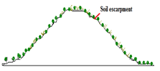
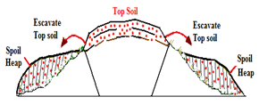
Figure 14A: Cross-Section of a New Borrow Pit Site 14B: Excavation; showing removal of Top Soil to Spoil Heap.
Pit Excavation
Standard excavators must be used to remove the dark topsoil and expose the red earth borrow material. Usually the excavated topsoil is dumped at the side of the planned pit as spoil heap. Area of topsoil removal and arrangement of spoil heap will depend on design of the borrow pit (Figure 14B). Bench height, width, slope and total depth of pit must be properly designed following information obtained from the preliminary site investigation. Unfortunately, borrow pits under investigation were opened and controlled by excavator operators without supervision. These operators have no knowledge of borrow pit design and slope stability requirements. As a result, both active and abandoned borrow pits in Nigeria have no designed bench heights or excavation plan. There was no consideration of pit slope and stability which results in pits having vertical walls, often with negative slope. This condition increases probability of sliding and risks.
Reclamation of borrow pits
As soon as borrow pit operation at a site is ended, and the project for which the borrow pit was opened is concluded (Figure 15A), reclamation should commence immediately. This is important especially where no new road project is envisaged within the area and any future road project will not be at close proximity for borrowing from the site to be economical. Reclamation is commenced by moving the spoil heap back to the pit, followed by moving adjoining topsoil to fill the pit (Figure 15B). There is no importation of fill material required. This operation goes with compaction of the fill material using roller and testing the compacted earth to achieve the original soil characteristics and ground condition (Figure 16A & 16B), and finally, accomplished by turning the reclaimed site green (Figure 17). The reclaimed site is completed by planting flowers, grass and trees to improve the natural look of a reclaimed site and improve ecosystem services. Reclaimed site can be used for structural development such as recreational activities, holiday resort and community gardens (Figure 17), depending on the land size. Figures 15-17, represents a step by step field operation and completion of a borrow pit reclamation program.
Following the environmental and Geotechnical site investigation carried out on the two abandoned borrow pits; recommendations are made to bring about sustainable environment with soil excavation. Firstly, operators of borrow pit should get the necessary permission from government Ministry of Environment. Secondly, proper geotechnical assessment should be carried out to avoid cases of trial pit that could eventually lead to abandoned borrow pit. To do this, the use of electrical resistivity measurement, which is a non-destructive or non-invasive methodology, should be employed before excavation. Thirdly, the government through its relevant agencies like the Environmental Protection and Regulatory Agencies should ensure enforcement of rules and regulations which include sitting a borrow pit about 200m from the edge of an existing or a proposed highway. Making sure the borrow pit operators signs an agreement of total reclamation or recovery of the land immediately after use, and provision of safety measures while operating the pit. Abandoned borrow pit could be reclaimed and turned to recreational park as source of revenue. Operators and contractors should be prosecuted, if they fail to comply with the directives.
Safety measures and pit control
Borrow pits active or abandoned should be provided some safety measures to reduce accidents and risks. There should be perimeter fencing of the pit area (Figure 18A), to prevent accident to human beings and other roaming animals into the pits. There should be only one gate for both entry and exit into the pit. The pit area and the gate must be guarded 24 hours daily by vigilante and security personnel to avert trespassing. Warning signs (Figure 18B) are necessary at strategic locations to inform passersby of the imminent danger ahead. Such signs must be simplified and easily understandable to all, including cattle grazers traversing the area.

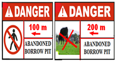
Figure 18A Perimeter fence decorated with safety warning sign. Figure 18B: (i) Danger; Movement Restricted, abandoned borrow pit 100 m a head (ii) Danger; Grazing Restricted, abandoned borrow pits 200 m ahead after.5
Although there have been few attempts to quantify potential risks from active and abandoned borrow pits, it is generally understood that the issue of abandoned borrow pits is a major environmental problem. The operators of borrow pits must agree on reclamation terms before opening the site. Government agencies and communities where the abandoned borrow pits are situated must enforce proper closing and reclamation of borrow pits. Lack of proper technical expertise has led to trial pit excavations which increases number of abandoned pits. Abandoned borrow pits cause landslides, initiates erosion and attracts dumping of wastes that cause contamination of surface and groundwater. An abandoned borrow pit site is a degraded land that scare potential land buyers and investors. It remains a strong indication of unsustainable engineering practice. Opening a borrow pit is necessary for socio-economic development, but reclaiming the borrow pit site immediately after use provides for sustainable environment.
None.
The author declares no conflict of interest.

©2017 Nwachukwu, et al. This is an open access article distributed under the terms of the, which permits unrestricted use, distribution, and build upon your work non-commercially.