Journal of
eISSN: 2378-3184


Research Article Volume 12 Issue 1
Retired Bureau of Meteorology Brisbane, Australia
Correspondence: Jeff Callaghan, Retired Bureau of Meteorology Brisbane, Queensland, Australia
Received: November 15, 2022 | Published: February 28, 2023
Citation: Callaghan J. Analysis of the June 2021 winter storm in Victoria with a catastrophic loss of large trees and major flooding. J Aquac Mar Biol. 2023;12(1):54-70. DOI: 10.15406/jamb.2023.12.00357
An extreme weather event which occurred in June 2021 stretched the rescue operations of Victorian Emergency Services due to major flooding and the unprecedented number of fallen large trees. The mechanisms which produced severe convection with gusts strong enough to bring down thousands of trees also produced the heaviest rainfall. The blocked roads and access to fallen power lines resulted in power outages lasting three weeks in some areas and some people were trapped in their houses for up to a week. The atmosphere around Melbourne was characterized by very strong vertical wind shear however convection was confined to mountainous areas southeast, east, and northwest of Melbourne. Overall, the region around Melbourne was in a stable atmosphere and convection was released by strong orographic lifting. Some of the heaviest rain fell on the Strzelecki Ranges and this drained into the city of Traralgon where near-record floods were reported. The event is compared with a Melbourne event in 2020 which caused three fatalities from fallen trees in the afternoon peak period. The fatalities were restricted with the current event due to it occurring just before and after midnight.
Keywords: waters, damage, storms, rainfall, power
VICSES, Victoria State Emergency Service; NCEP, National Centres for Environmental Prediction; WAA, warm-air advection; CAA, cold-air advection
On 13 June 2021, The Victoria State Emergency Service (VICSES) advised that they had the busiest week in the history of the service, with over 9,200 requests for assistance across the state and they responded to severe wind damage and riverine flooding. The number of fallen trees was unprecedented some of which were hundreds of years old. The blocked roads and access to fallen power lines resulted in power outages lasting three weeks in some areas. People were trapped in their houses in some locations around the Dandenong Ranges for up to seven days due to numerous fallen trees blocking access to roads. The convective activity leading to the severe wind gusts was restricted to mountain areas and this was where the heaviest rain was recorded. Some of the heaviest rain fell on the Strzelecki Ranges and this drained into the city of Traralgon where near-record floods were reported. The effect of orographic lifting in releasing severe convection capable of unprecedented wind gusts and flooding rainfall is described. There were significant telecommunications outages, with damage to over 400 NBN sites and over 200 mobile base stations. Two fatalities occurred in flood waters and one additional road fatality was attributed to thick fog on the morning of Friday 11 June. Fortunately, fatalities were restricted due to most of the fallen trees occurring just before and after midnight with people protected by their houses. The event is compared with two other events one which caused three fatalities from fallen trees and another similar event to the June 2021 storm which occurred during June 2012. This latter event while severe had nowhere near the impact of the 2021 event and differences in in the structures help identify important parameters crucial to the severity of these types of storms. The need to identify the severity of storms like this is that a high-profile warning is needed especially if it occurs in daylight hours or earlier in the evening when people are out and about, and many cars are on the roads.
Most of the data come from The Bureau of Meteorology website bom.gov.au however the following websites were used to obtain data after the event:
Seasonal composites (averages) of the mean or anomalies of variables from The United States National Centres for Environmental Prediction (NCEP) reanalysis and other data sets at the following site:
https://psl.noaa.gov/cgi-bin/data/composites/printpage.pl/hour/index.html
The NOAA HYSPLIT model for air parcel trajectory analyses using the GFS 0.25-degree global model June 2019 to the present at the following site: https://www.ready.noaa.gov/HYSPLIT.php
The extreme rainfall diagnostic used in this paper is based on the thermal wind relationship,1 which has been used to diagnose isentropic ascent and descent regions for decades, in which a component of the geostrophic wind is aligned with the thickness gradient, giving the appearance of warm-air advection (WAA) and cold-air advection (CAA) respectively. While the common derivation assumes geostrophic and hydrostatic balance, the relationship also holds for gradient wind balance,2 which means it is applicable to most intense rain-bearing systems at any latitude. In this paper WAA is analysed between the 850 and 500 hPa levels representing much of the lower troposphere. When sufficient moisture is present, wide-spread isentropic ascent in this layer often triggers broad scale and persistent convective rainfall.
The presence of the WAA wind structure in heavy rain-bearing systems is quite common, and the causal relationship well established. The disastrous freshwater flooding associated with Hurricanes Harvey and Florence and the 2005 Mumbai floods were associated with WAA winds.3–6 Previous studies7–10 examined winds associated with extreme rainfall in both the tropics and the Mid-latitudes of Australia. Further studies Callaghan3,11 found this to apply in many cases around the globe. Theoretical arguments2 suggest, assuming gradient wind balance that isentropic uplift is likely to be associated with winds that turn anti-cyclonically with height in most heavy rain-bearing systems, including the tropics and subtropics. Two Australian Studies Callaghan and Power examined extreme rainfall and major flooding events in coastal catchments and more broadly over south eastern Australia. Using radio sonde and re-analysis data they examined the vertical structure of these systems in the period when upper wind data became available. In every case (i) atmospheric moisture content was high and (ii) the low-level winds were onshore, and in almost every case (iii) the wind-direction turned anti-cyclonically with increasing height up to 500 hPa. Further details of this wind structure can be found in Callaghan and Power.7 Thunderstorm rainfall was also shown to have been enhanced when the WAA extended only up to 700hPa.
A tropopause undulation (TU) in Figure 1 has WAA flowing down to the south eastern edge of Australia and the Tasman Sea whereas in Figure 2 shows the 700hpa WAA overland in the south eastern edge of the continent. As a result (Figure 3), a low complex formed over Victoria12–14 and the nearby Tasman Sea by 1200UTC 9 June 2021 and then drifted north. A high-pressure ridge wraps around the low increasing the pressures over Tasmania by 1200UTC 9 June which had the effect of increasing the pressure gradient and winds over Bass Strait and Central Victoria.
Thousands of trees were blown down and experts couldn’t remember such a loss of trees. Forests scientists presumed it may have the unusual direction of the winds (south to southeast) whereas the area is usually attacked by extreme northerly to south-westerly gales and hence perhaps develop root structures to defend gales from this direction leaving them vulnerable to other wind directions. This will be discussed further below. Figure 4 shows the strong to gale force winds over the general Melbourne area with convection through the Dandenong and Strzelecki Ranges. Further west convection is seen developing on the ranges over the Daylesford and Trentham regions however this did not last that long, and it is thought the worst damage there occurred later.
In Figure 5 the rainfall distributions are displayed with the heaviest 24-hour totals occurring in the 24 hours to 2300UTC 9 June 2021. The heaviest totals occurred around Balook in the Strzelecki Ranges and around Mount Baw Baw along the Great Dividing Range. The heavy rain areas around Mount Baw Baw extended westward towards the Dandenong Ranges and this area along with the Strzelecki Ranges was where the worst of the tree damage was observed. A weaker rainfall maximum can be observed northwest of Melbourne, and this was over the high-country encompassing Mount Macedon and the Daylesford region where severe tree damage also occurred. Notice that the heavy rainfall areas and widespread tree damage were more or less collocated.
From the 700hPa charts at 0000UTC 9 June deep WAA (850hPa to 500hPa Figure 2 top frame) was evident about Gippsland and Melbourne. This had largely been replaced by shallower WAA up to by 700hPa 1200UTC 9 June (Figure 2 lower frame) and consequently there was a large reduction of radar echoes over the region except in the Mount Macedon area northwest of Melbourne where some deeper areas of WAA lingered (Figure 6). The shallower WAA however became conducive to the development of convection generated by orographic ascent as will be shown below.
The Melbourne upper winds while developing a more favorable structure for severe convection up to 700hPa at 1200UTC 9 June there was warming at low to mid-levels as cold air moved eastwards out of the area providing a stabilising influence. In the 12 hours to 1100UTC 9 June at 700hPa temperatures at Melbourne Airport warmed by 5.8C and at 500hPa temperatures warmed by 9.2C. Well known stability indexes indicated that the atmosphere over Melbourne became very stable thwarting thunderstorm development for example the Total Totals dropped from 52.8 to 41.4 while the lifted index (for virtual temperatures) rose from 2.69 to 6.89.
Melbourne Airport upper wind observations at 1100UTC 9 June leading into the damage was: 119metres elevation 190/29 knots 14.9 m/s 136metres elevation 185/13 knots 6.7 m/s211metres elevation 190/34 knots 17.5 m/s658metres elevation 185/58 knots 29.9 m/s925hPa 720m elevation 180/59 knots 30.37 m/s850hPa 1410m elevation 165/65 knots 33.46 m/s 700hPa 2966m elevation 140/70 knots 36.04 m/s
With maximum wind at 2819 metre 140/71knots 36.6 m/s
Such strong vertical wind shear is associated with stream wise vorticity,15 and this is the structure that produces tornado type storms in winter and in East Coast Lows and Tropical Cyclones along the east coast of Australia at landfall. They are associated with have lower buoyancy than severe tornadic storms in summer and generally can't be easily detected from weather radars.
These wind observations shown above for Melbourne Airport are conducive to the development of tornadoes or at least severe convection with rotating updrafts. The hodograph for this wind flight is displayed in Appendix I and compared with other tornado wind profiles which occurred in summer, winter and associated with east coast lows and tropical cyclones. The Melbourne profile at 1100UTC 9 June 2021 is typical of tornado profiles with winds turning in an anti-cyclonic direction up to 700hPa where the wind speeds are at least 15 m/s or 30 knots. In this case the wind speeds at 700hPa are well more than 15 m/s at 36.04m/s of 70knots.
Reanalyses winds from 6-hourly NCEP/NCAR Reanalysis Composites: NOAA Physical Sciences Laboratory (not shown) showed 850hPa winds across the Greater Melbourne area were greater at 1800UTC however the WAA turning between 850hPa to 700hPa was less (around 10 degrees) making it a little less favourable for severe convection.
The 850hPa analysis (Figure 7) chart around the time of the worst damage highlights the places most badly affected with all near the wind maximum which had a WAA structure up to 500hPa or 700hPa (which is conducive to severe convection.) All were over on near higher elevation areas of the Strzelecki Ranges and Dandenong and Macedon Plateaus.
Dandenong plateau
At Kalorama violent winds from 9pm to 5am (1100UTC to 1900UTC) were reported and at 2am (1600UTC) an enormous tree slammed into a lounge room at Kalorama. Country Fire Authority staff were called back into their base at 9:45pm as trees were downed everywhere with some roads blocked every 10 metres. Emerald’s SES pulled their team off the mountain at 1:30am (1530UTC) due to “hell on earth” with huge eucalypts trees downed some 80, 90 and 100 years old.
Report from Emergency Management Victoria Eastern metro region which includes Kalorama, Mount Dandenong, and Olinda:
Strzelecki ranges
Gippsland region which includes Traralgon and Yinnar South:
Boolarra, Budgeree and Yinnar South resembled a war zone, with roads blocked by thousands of fallen trees which had taken out power lines, some houses, sheds, and major infrastructure. Yinnar South locals Ben Dawson and Marc McKinlay stated, “I’ve experienced wind, but this was on the next level, it kept changing direction, it was swirling.” They said Whitelaw’s Track was completely blocked-off with about 30 trees down in the space of 500 metres. Budgeree beef farmer Edgar Owen had joined other local farmers to clear Budgeree Road, stating his farm lost 200-year-old trees. He stated “When we cleared this farm 50 years ago, the dozer could not shift these trees, but this wind has done it in one go. It even blew my big old cypress out, and they usually don’t blow over.”
At school pick up time, Mother Kat Gration had already noticed the wind was blowing hard. Some trees and lines had fallen across roads, however she journeyed home to a rural patch of Mirboo East (near Yinnar South) not expecting to be trapped there for four days without power and running water. At 11.20pm (2320UTC), she and husband Brenton woke up to a large bang. There was also the sound of metal tearing from rooftops and glass shattering. “I looked out the window and saw the power lines smashed up all around the house,” she says. “The trees were so thick across the driveway we couldn’t get out
Mount Macedon region
Victoria Emergency said there had been more than 900 requests for assistance across the Macedon Ranges after damaging winds on the 10th. From 19 June Woodend (Macedon Ranges) SES unit had responded to 560 requests for assistance since the storm began. The worst was on 10 June.
Through the Northwest which includes Trentham, Daylesford, and surrounding areas:
Rainfall over the six months prior to June 2021 was mostly average in the area so probably not a large factor in the number of fallen trees.
Lifting of layers producing static instability conducive to convection
Ascent by dynamical or orographic means can destabilise atmospheric layers. This occurs when the top portion of the layers cool at the dry adiabatic lapse rate while in the lower portion where cloud begins to form, cools at a lower rate (the moist adiabatic lapse rate).
The Hysplit trajectories from 0000UTC, 0900UTC and 1200UTC (Figure 8) show the different effects of the deep WAA and that of shallower WAA along with orographic ascent. At 0000UTC 9 June Figure 7 shows a layer being lifted over terrain to 4000m elevation while the trajectory reached the Eildon area. By 0900UTC ascent was restricted with the airstream being lifted above 2500m elevation to the high-country area east of Lilydale and at 1200UTC above 2000m elevation to the ranges north of Melbourne.
Before the WAA was restricted heavy rain (33.0mm) fell at Yarram (elevation 18m) on the coast near the Strzelecki Ranges in the 6 hour to 0500UTC 9 June 2021 while up on the ranges in the 7hours to 0600UTC 65.0mm fell at Mount Tassie (elevation 546m), 59.0mm at Jeeralang North (elevation 340m) and 62.4mm at Balook (elevation 585m). From Figure 2 the whole area which was in a WAA environment changed after 0600UTC to an environment where the WAA extended up only to 700hPa. From then on only light rain fell at Yarram (27.8mm from 3pm to 9am on 10 June) while up on the ranges very heavy rain fell over this period with Mt Tassie recording 202.0mm from 4pm to 9am 10 June (0600UTC to 2300UTC 9June), Jeeralang North 163.0mm and Balook 153.0mm over the same period. Traralgon Creek flows from high on the Strzelecki Ranges near Balook and Mount Tassie into the City of Traralgon where a major flood of 5.8m occurred at 2300UTC 8 June 2021.
The very heavy rain and destructive wind damage were due to severe convection (with possibly small tornadoes) over the higher country. From Figure 2 (lower frame) the WAA structure up to 700hPa shown over much of the damage area was conducive to severe convection. All the extreme damage areas were over higher elevation areas of the Strzelecki Ranges and Dandenong and Macedon Plateaus.
The winds at Yarram show very strong to gale force (17 m/s) winds onto the slopes of the Strzelecki Ranges up to Balook almost throughout 9 June (UTC) providing strong ascent up these slopes.
Yarram 0100UTC 150/14.4 m/s
Yarram 0300UTC 160/11.3 m/s
Yarram 0400UTC 150/14.4 m/s
Yarram 0500UTC 150/11.8 m/s
Yarram 0700UTC 170/13.4 m/s
Yarram 0800UTC 170/16.0 m/s
Yarram 0900UTC 170/16.0 m/s
Yarram 1000UTC 170/17.0 m/s
Yarram 1100UTC 160/16.5 m/s
Yarram 1300UTC 150/18.0 m/s
Yarram 1400UTC 150/16.5 m/s
Yarram 1500UTC 160/17.0 m/s
Yarram 1600UTC 150/18.0 m/s
Yarram 1700UTC 150/15.9 m/s
Yarram 1800UTC 150/14.4 m/s
Yarram 1900UTC 150/15.3 m/s
Yarram 2000UTC 160/13.9 m/s
Yarram 2100UTC 160/14.9 m/s
Yarram 2200UTC 160/15.3 m/s
Yarram 2300UTC 170/14.9 m/s
The Hysplit trajectories at 1200UTC and 1500UTC 9 June (Figure 9) show the ascent from Traralgon as the airstream is lifted above 2000m elevation above the ranges near and east of Kalorama. At 1700UTC trajectories are lifted near 2000m elevation near Gembrook.
The Hysplit trajectories from northern Port Phillip by at 1600UTC and 1700UTC (Figure 10) show how terrain lifted layers up to 2000m as they moved towards the Macedon Plateau. Figures 11 & 12 shows the strong to gale force south to southeast winds over the region with strong convection around Balook and the Dandenong Ranges and more briefly developing over the Macedon Plateau.
During August 2020 there was major tree damage when a frontal system passed through Melbourne (Figure 13). Sadly 3 fatalities were caused by fallen trees in westerly winds. Melbourne winds just before the event showed WAA structure and 700hPa wind speeds of 16.88m/s which favoured rotating updraft convection.
2300UTC 26 August 2020 Melbourne
1008hPa 005/8.75 m/s
1000hPa 355/9.78 m/s elevation 181.00 metres
944hPa 320/22.14 m/s
925hPa 315/25.23 m/s elevation 828 metres
850hPa 290/23.68 m/s elevation 1526 metres
700hPa 260/16.99 m/s elevation 3077 metres
500hPa 250/18.02 m/s elevation 5640 metres
On 27 August 2020 a four-year-old boy is one of three people who have died from falling trees after wild winds swept across Melbourne, bringing down trees. One fatality occurred at Blackburn South, one at Belgrave and one near Healesville. SES chief officer said the service had received more than 2,700 calls for assistance, almost 2,000 of which were received in a 15-minute period around 6:00pm (0800UTC) by which time the windstorm had reached the far eastern suburbs (Figure 1). Felled trees made up 85 per cent of calls to the State Emergency Service. More than 300 buildings were "severely damaged" across the state. The location of the tree fatalities can be seen in Figure 1.
Reported wind gusts for this event are compared with those of the June 2021 event in Appendix II. The worst wind gusts in the Melbourne area were in 2020 but overall, there is not a lot of difference. However, the worst damage in the 2021 events was over areas well away from automatic weather station reports and additionally this event occurred over may hours whereas in 2020 the worst of the damage occurred on the frontal passage over eastern areas of Melbourne.
Rainfall over the six months prior to August 2020 was mostly above average in the area so probably had some role in the number of fallen trees.
During this event there were numerous road closures across the east of Victoria due to flooding and fallen trees, with the SES receiving over 1500 requests for Assistance. Up to 100 residents in low-lying parts of Traralgon were evacuated when 45 homes were flooded from an overspill out of Traralgon Creek. The Traralgon Creek at Traralgon around 1700UTC 4 June 2012 peaked at 5.3 metres (Major Flood Level 4.5 metres).
The twenty-four-hour rainfall analyses to 2300UTC 4 June 2012 (Figure 14) show a similarity to the rainfall distribution to 2300UTC 9 June 2021 with the heaviest rainfall on the three mountainous regions. On the Strzelecki Ranges Balook recorded 125mm 12hours to 1100UTC 4 June and 19.2mm 1100UTC to 2300UTC 5 June. At the foot of the ranges Yarram recorded 32.0 mm in the 12 hours to 1100UTC 4 June and 5mm from 1100UTC to 23Z 4 June showing how convection developed on the 20km slope up the ranges.
The Melbourne Airport winds midway through this heaviest rainfall period at 0500UTC 4 June 2912 were:
300 metres 155/9.5 m/s
850hPa 135/22.14 m/s
700hPa 130/13.90 m/s
While these wind observations have the WAA structure, the 700hPa wind speeds are much less than the 36.04m/s recorded at 1100UTC 9 June 2021. This would indicate much more vigorous convection developed in June 2021 with perhaps even some small tornadoes present.
Rainfall over the six months prior to June 2012 was very much above average in West Gippsland and the Mornington Peninsula and average to above average in the remainder. So trees in sodden soil would have played some role in the number of fallen trees especially since the Mornington Peninsula reported many trees down.
An event like that which occurred overnight (local time) on the 9-10 June 2021 has the potential to cause significant loss of life thus use of the Standard Emergency Warning Signal (SEWS) would possibly be justified in some situations. The SEWS is a warning siren used in Australia alert the public of the danger. The siren is played over radio, television, or public address system in public places to warn of bushfire, flood, cyclone, tsunami, earthquake, or terrorist attack. Obviously to use the SEWS for a weather system the event must be clearly identified as such a threat as overuse of the SEWS can destroy its effectiveness. The risk of a fatality from a fallen tree is extremely low however the risk is greatly enhanced if people are out and about in weather events such as the August 2020 event or an event like the June 2021 event if it occurred in daylight hours.
Analysis of the June 2021 event indicated that severe wind gusts strong enough to bring down numerous trees from severe convection were unlikely over much of Victoria due to the atmosphere having strong static stability. However the wind structure in the greater Melbourne region had extremely strong vertical wind shear in the lower levels up to 3km elevation and if convection could develop it would possibly cause much damage. The release of strong convection was found to be associated with orographic lifting such that all the destructive wind gusts occurred in mountainous areas. Populated mountainous areas such as the Dandenong Ranges appear to be the most vulnerable in these types of situations.
The event is compared with two other events one which caused three fatalities from fallen trees and another similar event to the June 2021 storm which occurred during June 2012. This latter event while severe had nowhere near the impact of the 2021 event and differences in in the structures help identify important parameters crucial to the severity of these types of storms. The need to identify the severity of storms like this is that a high- profile warning is needed especially if it occurs in daylight hours or earlier in the evening when people are out and about, and many cars are on the roads.
The author declares no conflicts of interest.
No funding was received for this study.
The two anonymous reviewers provided excellent guidance to progress this paper into a publishable form.
Tornado wind structures
The hodograph for Melbourne at 1100UTC 9 June 2021 leading into the severe tree destruction is shown below in Figure A1. This structure of winds turning in an anticyclonic direction with height and with high wind speed by 700hPa is shown below to be a common wind structure for tornadoes or rotating updraft storms. Super cells (and Tornadoes) can also occur in a wind pattern when they turn cyclonic with height though this is relatively rare.15
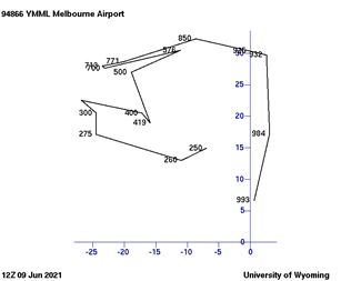
Figure A1 Hodograph for Melbourne Airport winds at 1100UTC 9 June 2021 with winds in meters per second and pressure levels shown from 993hPa up to 250hPa.
This common wind structure is found in the environment of most tornadoes be they occurring in warm or cool seasons or associated with tropical cyclones (TCs) or Australian east Coast Lows (ECLs). This consists of wind directions turn anticyclonically with height up to about 700 hPa where the winds reach speeds of about 15 m/s. The difference lies in the buoyancy where warm season tornadoes occur in strongly buoyant environments, cool season tornadoes in low buoyancy environments and the TCs associated with TCs and ECLs between these two extremes.
From Markowski et al16 mean hodographs for US severe thunderstorms show they all have the clockwise turning (anticyclonic) up to about 700hPa (just over 3km elevation). The tornadic composites have stronger winds (around 15m/s) at that level. A Californian winter tornadic storm is added for comparison17 and it is similar with 10000 feet (near 700hPa) winds reaching 15 m/s (Figure A2 & A3).
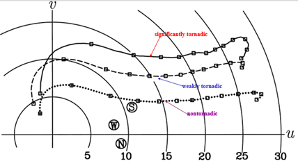
Figure A2 Mean hodographs for significantly tornadic, weakly tornadic and non-tornadic environments. The circled S, W and N indicate storm motions for the three classes. Winds every km elevation Units are m/s. From Markowski et al.16
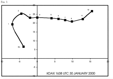
Figure A3 Cold season hodograph of a Californian tornado 1638 UTC 30 Jan 2000. Wind components: m s−1. Elevations: 1000feet.
Cold season tornadoes
Southern Australian and Californian cold season tornadoes from Kounkou et al18 and Hanstrum et al17 were shown to be associated with low buoyancy and extremely large values of low-level bulk and positive shear, as evidenced by strongly anticyclonically curved hodographs.
Three F2 tornadoes occurred over southwest WA during the mid-afternoon (between 0600 and 0800 UTC) on 7 June 1995. Perth winds showed anticyclonic turning increasing from 320/12.36 m/s at 300 metres to 300/26.77 m/s at 2100m elevation. The magnitude of the surface-to-1-km shear was 16 m s−1. Static stability was relatively high indicative of these low buoyance high shear storms.
Three F2 tornadoes were observed in southern SA between 0700 and 0800 UTC 21 July 1995.
The wind profile at Adelaide at 0500UTC showed anticyclonic turning up to 2100m and an increase in wind speed from 10 m s−1 at the surface to 21 m s−1 at 1500 m above the surface.
Tornado events that occurred in SA and WA during the Southern Hemisphere cool season, May–September, were extracted from the Australian Severe Thunderstorm Database for the period 1987-96. Events were associated with relatively low values of buoyancy and the greatest shear values were found in the 0–1-km layer. In the WA cases, 0–1-km shears were also stronger for the F1–F3 cases than for the F0 cases.
The studies in both California and Australia show that these cool-season storms occur with CAPE values typically 200-400 J kg−1, slightly negative 700-hPa Surface Lifted Index with 0–1-km shear of greater than 10−2 s−1. It has been shown that buoyancy does not necessarily discriminate between more and less damaging storms, but that the 0–1-km positive shear does provide such discrimination.
Recent Perth examples of winter tornadoes
Six Perth storms producing tornadoes where the winds mostly turned anti cyclonic in the lower levels with 700hPa winds speeds mostly reaching 15 m/s
Perth 9 June 2008 A tornado swept through the southern suburbs of Perth just after 2330UTC 8 June and damaged more than 130 homes.
Perth winds 2300UTC 8 June 2008
998hPa 360/10.81 m/s
925hPa 350/26.25 m/s 659 m elevations
850hPa 315/27.80 m/s 1365 m elevation
700hPa 320/24.71 m/s 2949 m elevation
Perth 20 May 2011 Canning Vale was struck by tornado, damaging several homes.
Perth winds 2300UTC 19 May 2011
1008hPa 360/5.66m/s
1000hPa 355/7.72m/s 80melevation
925hPa 310/22.65m/s 743 m elevations
850hPa 315/22.65m/s 1454m elevation
700hPa 300/28.83m/s 3053m elevation
Perth 7 June 2012 Tornadoes struck the Perth suburbs of Dianella and Morley, damaging homes, trees, and power lines. A tornado also struck York 100 km (62 mi) east of Perth. A total of 100 homes and buildings were damaged.
Perth 2300UTC 6 June 2012
1007hPa 045/3.60m/s
1000hPa 030/4.63m/s 73 m elevations
925hPa 325/13.38m/s 729 m elevations
850hPa 305/12.36m/s 1433m elevation
700hPa 10/13.38m/s 2995m elevation
At 0500UTC 7 June 2012 700hPa 300/21.11m/s
Perth 14 July 2014 As many as four tornadoes impacted the metropolitan area around Perth with 2 fatalities.
Perth 1700UTC 13 July 2012
914m 320/12.87m/s
1524m 315/16.99m/s
2438m 315/16.99m/s
3658m 285/15.96m/s
Perth 7 September 2014 Forrestfield (suburb, southeast of Perth) the damage to Forrestfield included felled trees, damaged roofs, and downed light poles.
Perth 0500UTC 7 September 2014
914m 320/8.24m/s
1219m 315/8.24m/s
2134m 295/13.90m/s
2743m 285/36.04m/s
3658m 295/41.70m/s
Perth 31 July 2017 The tornado moved in the morning through northern suburbs causing trees down and building damage.
Perth 2300UTC 30 July 2017
1014hPa 010/8.24m/s
1000hPa 345/12.36m/s 132 m elevations
925hPa 320/15.96m/s 782 m elevations
850hPa 310/20.08m/s 1476m elevation
700hPa 300/31.40m/s 3028m elevation
Winter tornadoes elsewhere
Qld darling downs 2013 June 12
Houses were demolished in the Pratten area 25km NW of Warwick (elevation 474m) on Wed evening and attached radar and obs (wind, mslp and Temp/DP) at 7pm 12 June shows the storm developing west of Pratten with NW to NE seabreeze type confluence and decent DPs (for June) over the region (good for storms).
Brisbane winds 1200UTC 12 June 2012 around the time showed the anticyclonic turning up to very strong 700hPa winds.
1011hPa 005/9.3m/s 5m elevation
1000hPa 005/14.41m/s 104.00 m elevations
925hPa 350/19.05m/s 771.00 m elevations
850hPa 350/16.99m/s 1488.00 m elevations
700hPa 320/31.40m/s 3097.00 m elevations (Figure A4)
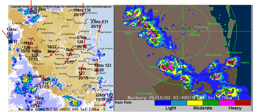
Figure A4 Left panel radar 0900UTC 12 June 2013 showing severe thunderstorm approaching Pratten mean win observations are show with truncated pressure to 1 decimal point and temperature and dewpoint in Celsius. For comparison a high buoyancy severe thunderstorm near Warwick and the thunderstorm on the Gold Coast were particularly severe with many cars and 400 homes were damaged by large hail.
Devastating Adelaide line of tornado 28 September 2016 causing massive power disruption (Figure A5)
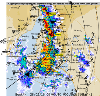
Figure A5 Line of severe thunderstorm between 0500UTC and 0600UTC 28 September is shown in moving across the Yorke Peninsula.
Leading into this the atmosphere became mostly warmer and more humid about Northern Spencer Gulf. For example, Cleve’s Temperature and dewpoint increased from 11.5C/8.1C to 18.9C/13.1C.
Adelaide winds fit the pattern described above at 0500UTC 28 September 2016 (From models winds a little stronger Clare and Melrose area) 610metres 020/56knots 914metes 010/54 knots 1524 metres 340/62 knots 2134 metres 325/52knots 2438metres 315/44metres 3658metres 325/60 knots.
With this sub-tropical inflow, a very severe impact from this line of storms came with tornadoes which were sighted at Blyth (near Clare) and at Melrose (halfway between Clare and Port Augusta). It was reported that 22 high voltage transmission lines towers (usually designed to withstand gusts of 100 knots or more) were blown down. This led to the massive South Australian Power Blackouts.
Australian summer tornadoes
These also mostly show the wind turning ant cyclonically with height up to 700hPa winds of 15m/s or more but with much stronger buoyancy (and radar echoes).
Brisbane
4 November 1973 -Tornado Brookfield to 8 Mile Plains Length of track 51 km and 100 m to 230 m wide, 500 houses were unroofed, 1390 damaged and 500 declared structurally unsafe.
0400UTC 900hPa 330/14.9m/s; 850hPa 340/19.0m/s; 700hPa 320/29.9m/s; 500hPa 280/28.3m/s (Figure A6)
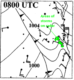
Figure A6 MSL analysis 0800UTC 4 November 1973 showing from radar the line of thunderstorms just west of Brisbane which spawned the tornado.
Rockhampton 0430UTC 2 November 2000
A severe storm tore a path of destruction through the suburbs of North Rockhampton with reports of up to 5 tornadoes (evidence of at least 1 confirmed by the Bureau). Widespread tree damage and roofing damage to some houses. Golf ball sized hail was observed in the outer suburbs with wind estimates to 80 kts but only 42 kts measured at the Rockhampton airport. A large truck was lifted and thrown about 50m.
0000UTC 2 Nov 2000 Rockhampton
383metres 335/4.5m/s
1304metres 312/12.5m/s
1643metres 303/13m/s
1829metres 300/13m/s3881metres 259/14m/s
Narangba 0500UTC 27.11.2005
A tornado was observed at Narangba, an outer northern suburb of Brisbane. Trees were completely sheared off and garden sheds blown away. A caravan was over-turned; tiles and iron sheets were torn off roofs. At Narangba Timbers, some exceptional damage was observed. Heavy timber beams were torn from the roof of the shed.
Brisbane 2300UTC 26/11/2005
1000hPa 025/8.24m/s 95 m elevations
925hPa 355/7.21m/s 773 m elevations
850hPa 330/10.81m/s 1498m elevation
700hPa 270/10.30m/s 3123m elevation
700hPa wind speed increased to 17.5m/s by 1100UTC 27/11/2005
Kurnell tornado
Port Botany (Molineux Point) 5km from Sydney Airport reported Southerly winds gust at 143km/h(77knots) at 2346UTC 15/12/2015 (Figure A7).
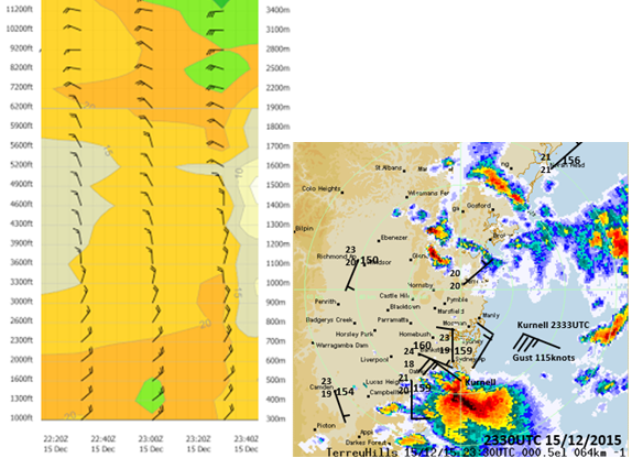
Figure A7 Wind profiler Sydney Airport 15/12/2015(left) and in right frame radar image of Tornado at Kurnell (8km from Sydney Airport).
A tornado that hit the Sydney suburb of Kurnell (8km from Sydney Airport) on the morning of December 16, 2015, cost insurance companies $206 million, making it the most expensive disaster of the summer. Destructive winds measured up to 213 kilometres per hour, while some areas were pelted with golf ball-sized hail stones. The gusts at Kurnell AWS reached 115knots or 58.6m/s, which are the strongest on record in New South Wales (Figure A8).
Kiama tornado
Sydney winds 1700UTC 23 Feb 1500m 010/15.44m/s; 1829.0m 005/16.47m/s; 2134.00m 010/17.50m/s 2438.00m 015/16.99m/s; 3353.00m 010/20.08m/sHouses in about 20 streets were severely affected by the massive storm. Redcliffe tornado24th Dec 1989... Redcliffe Tornado with severe wind damage also in Brisbane Yacht at Newport Marina in Redcliffe recorded winds more than 100 knots. 500 homes were unroofed and 12 declared structurally unsafe. Redcliffe SES reported 1245 houses issued with tarpaulins on the Peninsula. There were also hundreds of similar cases in Brisbane. An 18yr old girl was drowned when she was trapped in the cabin of a 6m cruiser which was lifted out of the water and capsized at Toorbul. Brisbane Airport winds 0400UTC 24 December 1989 940hPa 345/5m/s 900hPa 320/5m/s850hPa 270/7.5m/s 780hPa 265/7.5m/s 700hPa 250/15.4m/s (Figure A9) Kalgoorlie 4 December 2015At about 3:30 pm "tornado-like conditions" swept through mobile fleet maintenance workshops causing major structural damage and cutting power, communication, and water services. Kalgoorlie 0500UTC 4 December 2015

Figure A9 Location or radar echoes with rain echo tops in hundreds of feet (650= 65,000feet) at 0545UTC 24 December 1989 (left) and 0555UTC 24 December 1989 (right).
1524.00m 325/3.09m/s
1829.00m 315/5.15m/s
2134.00m 335/9.27m/s
3048.00m 315/18.02m/s
3658.00m 320/24.71m;s
4267.00m 320/26.25m/s
Tornadoes associated with tropical cyclonesTropical cyclone Lua Tornado at Townsville 5.07am 20 March 2012 with 8 houses condemned, 30 houses extensively damaged and 50 houses with minor damage. Surface observation at Townsville 05:07am 20 March 2012 Temp 24.9C Dewpoint 24.8C wind NNE 41knots gust 60knots.Townsville winds 1100UTC 19 March 2012 925hPa 070/8.8m/s 734 m elevations850hPa 030/9.8m/s 1468 m elevation 700hPa 350/17.5m/s 3117 m elevation Townsville winds 2300UTC 19 March 2012 925hPa 015/14.9m/s 722 m elevations 850hPa 005/17.0m/s 1456 m elevation 700hPa 335/23.2m/s 3102 m elevation Tropical cyclone TashaTornado at Alligator Creek near Mackay, QLD between 10 and 11am AEST on Christmas morning 2010. The news here showed some damage in the area (metals roofs ripped off and wrapped around trees, etc) Funnel cloud sighted (photo evidence). Mackay winds 2300UTC 24/12/2010Surface (30 metres): 5.1m/s1000hPa (54 metres): 110/6.2m/s978hPa (300 metres): 105/14.4m/s971hPa (317 metres): 105/14.4m/s943hPa (600 metres): 095/16.0m/s910hPa (900 metres): 085/17.5m/s884hPa (135 metres): 075/35m/s850hPa 75.00 17.50m/s 700hPa 65.00 15.96m/s
Tropical cyclone Joy
Early on 27 December 1990 a tornado at Mackay demolished 2 houses, damaged another 40 and caused extensive damage in a seaside caravan park.
Only moderate surface winds around Mackay with storm force winds just above the surface. Intense stream wise vorticity. Mackay 1600UTC 26 December 1990
609metres 070/26.77m/s
914metres 070/26.77m/s
850metres 070/25.74m/s
700hPa 045/21.62m/s
500hPa 005/15.44m/s
Tropical cyclone George 2007 genesis Kakadu
On 1 March 2007 at Kakadu National Park a powerful tornado carved a trail of destruction through forest near the Mary River Ranger Station 200km SE of Darwin. Two unoccupied caravans were destroyed, and many trees were snapped and felled around the rangers’ houses and office. The 3-kilometre-long damage swath passed within a few hundred metres of the Ranger Station. In the worst affected areas, hardwood trees such as eucalypts and ironwoods were uprooted or torn apart. In many instances large, mature trees were reduced to de-barked and de-foliated stumps with only some larger branches remaining. Curved trails of debris provided stark evidence of the clockwise spiralling winds around the centre of the tornado. The caravans and a washing machine were lifted and tumbled over distances up to 100 metres by the destructive winds in the 300-metre-wide tornado. Severe Weather Meteorologist Greg Browning said that the tornado formed during the evening of March 1st under a line of thunderstorms near a tropical low over Arnhem Land. This low caused record-breaking rainfall that flooded the Oenpelli and Adelaide River areas, and then developed into Tropical Cyclone George a few days later. Mr Browning said that tornadoes occur infrequently in the tropics, but atmospheric conditions favourable for rotating thunderstorms sometimes occur on the periphery of tropical lows and cyclones.
The Bureau estimated that winds in the tornado were between 230 and 270 km/h, based on an assessment of damage to trees and caravans using the five-point Fujita Scale. This scale is used to rate the intensity of tornadoes by the US National Weather Service.
Darwin winds 0500UTC 1 March 2007
850hPa 255/15.44 m/s
700hPa 170/16.99 m/s
500hPa 160/15.44 m/s
1100UTC 1 March 2007
1000hPa 38m 270/1m/s
997hPa 65m 268/1.5 m/s
925hPa 730m 265/7.21 m/s
850hPa 1469m 220/10.81 m/s
700hPa 3113m 180/18.02 m/s
Example of the worst known hurricane tornado outbreak in US historyHurricane Ivan
The worst outbreak of Tornadoes in the US associated with a tropical cyclone occurred during the landfall of Hurricane Ivan in September 2004.19–21
The Hurricane Ivan tornado outbreak was a three-day tornado outbreak that was associated with the passage of Hurricane Ivan across the Southern United States starting on September 15, 2004 across the Gulf Coast states of Alabama and Florida as well as southern Georgia before ending in the Middle Atlantic Coast on September 18.
The outbreak killed 8 people and injured dozens of others across several states from Florida to Pennsylvania. Overall, it produced 120 tornadoes (NCDC data base) surpassing the record of 117 that was previously held by Hurricane Beulah during the 1967 Atlantic hurricane season. The tornadoes around the time of landfall formed mostly in the WAA area east of the centre. At least 8 people were killed and 17 injured by the tornadoes. On 15 September, some of the more significant tornado events occurred between the eye of Ivan and Tallahassee -an F2 tornado occurred near Panama City Beach (Bay Co.), FL resulting in 1 death and 7 injuries; a second F2 tornado occurred near Blountstown (Calhoun Co.), FL resulting in 4 deaths and 1 injury; a third tornado (intensity undetermined) killed 2 people in Panama City, FL a little more than 1h after the F2 tornado had struck the area.
In Table 1 the winds at Tallahassee show the familiar WAA structure with strong wind speeds at 700hPa (Figure A10) (Table A1).23
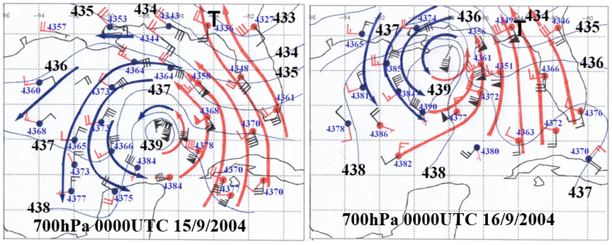
Figure A10 Wind plots (black) at 700hPa from radiosonde and dropsonde observations with red plots 850hPa to 500hPa wind shears and blue and red streamlines indicating cold and warm air advection both for 0000UTC 15 September 2004 (left) and 0000UTC 16 September 2004 (right).The location of Tallahassee is marked by T.
|
Date time UTC |
Height and Wind in m/s |
Height and Wind in m/s |
Height and Wind in m/s |
Height and Wind in m/s |
Height and Wind in m/s |
Height and Wind in m/s |
Height and Wind in m/s |
|
18Z 14 September 2004 |
53m 70/3.6 |
149m 077/5.1 |
381m 093/9.3 |
610m 110/13.4 |
830m 110/13.9 |
914m 115/13.9 |
700hPa 160/4.6 |
|
06Z 15 September 2004 |
53m 080/4.6 |
127m 085/8.2 |
305m 100/18.5 |
430m 100/18.5 |
610m 110/19.0 |
914m 120/19.6 |
700ha 170/6.7 |
|
12Z 15 September 2004 |
53m 070/4.6 |
115m 075/6.7 |
305m 105/16.0 |
610m 115/18.5 |
797m 120/19.6 |
914m 125/21.1 |
700hPa 175/6.2 |
|
18Z 15 September 2004 |
53m 080/5.1 |
123m 086/6.7 |
474m 114/15.4 |
610m 125/18.5 |
807m 130/19.0 |
914m 130/20.1 |
700hPa 155/22.1 |
|
00Z 16 September 2004 |
53m 075/3.6 |
079m 077/4.1 |
469m 100/10/8 |
925m 118/16.5 |
1219m 140/24.7 |
1501m 145/25.2 |
700hPa 180/27.3 |
|
12Z 16 September 2004 |
53m 100/12.9 |
68m 105/13.4 |
305m 155/25.7 |
610m 165/26.8 |
754m 165/27.3 |
914m 170/28.8 |
700hPa 190/28.9 |
|
00Z 17 September 2004 |
53m 180/7.7 |
305m 195/16.5 |
610m 205/18.5 |
741m 205/18.5 |
914m 205/19.0 |
1219m 205/18.5 |
700hPa 245/22.1 |
|
12Z 17 September 2004 |
53m 230/2.1 |
93m 230/3.6 |
305m 245/13.9 |
610m 255/14.4 |
775m 255/15 |
914m 260/16.47 |
700hPa 265/17.5 |
Table A1 Tallahassee upper winds 1800UTC 14 September 2004 to 1200UTC 17 September 2004
Comparison of severe gust reports on 27 August 2020 and 9 June 2021
The winds had stronger gusts on 27 August 2020 compared with the June 2021 event. For example, in the Melbourne suburbs the strongest gust was 115km/h (62knots) at St Kilda Boat Harbour at 0754UTC while the strongest mean wind around that time was 230/72km/h (39knots) at 0800UTC. The strongest gust there on 9 June 2021 was 96km/h (52knots) at 10:49UTC when the mean was 190/69km/h (37knots). Note the mean wind in 2021 generally has stronger wind speeds but the gusts were weaker. Radar showed strong convective activity on the front in 2020 whereas convection was weaker closer to Melbourne in June 2021. But overall, it doesn’t seem that the tree route systems defended the westerly winds all that well. Table A2 Surface winds comparison between 27 August 2020 and 9 June 2021.
|
Station |
Max wind gust and mean wind 27 August 2020 |
Max wind gust and mean wind 9 June 2021 |
|
Wallan (Kilmore Gap) |
72km/h(39knots) 310/33km/h(18knots) at 0646UTC |
104km/h(56knots) mean 190/54km/h(29knots) at 9:16pm; |
|
Avalon
|
104km/h(56knots) mean 250/76km/h(41knots) at 0722UTC |
Avalon 80km/h(43knots) mean 190/55km(30knots) at 1141UTC |
|
Wilsons Promontory
|
158km/h (85knots) mean 270/61km/h(33knots) at 0731UTC |
113km/h(61knots) mean 150/89km/h(48knots) at 0937UTC |
|
Yanakie
|
122km/h(66knots) mean 300/50km/h(27knots) at 0729UTC |
70km/h(38knot) 170/41km/h(22knots) at 1051UTC |
|
Yarram
|
96km/h(52knots) mean 250/74km/h(40knots) at 0807UTC |
89km/h(48knots) mean 150/65km/h(35knots) at 1059UTC |
|
Pound Creek
|
96km/h(52knots) mean 280/46km/h(25knots) at 0721UTC |
83km/h(45knots) mean 170/55km/h(30knots) at 1032UTC |
|
Cerberus Naval Base |
100km/h(54knots) mean 280/63km/h(33knots) at 0710UTC |
95km/h(51knots) mean 170/70km/h(38knots) at 2350UTC |
|
Rhyll
|
82km/h(45knots) mean 280/21kmh(11knots) at 0709UTC |
81km/h (44knot) mean 170/50km/h(27knots) at 1222UTC |
|
Saint Kilda Harbour |
115km/h(62knots) mean 270/59km/h(32knots) at 0744UTC |
96km/h(52knots)mean 190/69km/h(37knots) at 1049UTC |
|
Fawkner Beacon |
115km/h(62knots) mean 280/58km/h(31knots) at 0737UTC |
95km/h(51knots) mean 160/76km/h(41knots) at 01:00am |
|
South Channel Island |
100km/h(54knots) mean 240/83km/h(45knots) at 0730UTC |
96km/h(52knots) mean 170/78km/h(42knots) at 1130UTC |
|
Viewbank |
93km/h(50knots) mean 220/50km/h(27knots) at 0801UTC |
72km/h(39knots) Mean 190/35km/h(19knots) at 0946UTC. |
Table A2 Surface winds comparison between 27 August 2020 and 9 June 2021

©2023 Callaghan. This is an open access article distributed under the terms of the, which permits unrestricted use, distribution, and build upon your work non-commercially.