International Journal of
eISSN: 2576-4454


Case Report Volume 1 Issue 4
Tianjin Institute of Meteorological Science, China
Correspondence: Wang Wei, Tianjin Institute of Meteorological Science, China, Tel 086-022-23358783
Received: September 13, 2017 | Published: October 16, 2017
Citation: Wei W. The application of navigation satellite reflect signal to observation of tianjin’s sea ice in China. Int J Hydro. 2017;1(4):94-95. DOI: 10.15406/ijh.2017.01.00018
The thick sea ice is severe disaster in Bo Hai in North China. So the Monitor of sea ice is necessary to defend the sea ice disaster. Author try to monitor the sea ice with the reflect signal of navigation satellite system. Therefore, a receiver of reflect signal of navigation satellite system is developed, which can receive two new reflect signal, i.e. the vertical polarization and horizontal polarization. The equipment of receiving reflects signal locates in the coast of Tianjin in China. Finally, the retrieval thickness of sea ice are acquired with the data of reflect signals of vertical polarization and horizontal polarization. The results show that thickness of sea ice could be retrieved with polarization data of reflect signal of navigation satellite system.
Keywords: Sea ice, GNSS-R, Vertical polarization, Horizontal polarization, Observation station
As an important part of the climate system, the sea ice has attracted more and more attention to scientists. However, due to the environment complexity of sea ice and the persistence of cloud cover, the sea ice observation is difficult with conventional instruments. With the progression of navigation satellite system, the technique has been seriously concerned for monitoring sea ice with the reflect signal of navigation satellite system. In the future, there are the rich microwave signal sources for ocean surface observations due to the existence of more than 100 satellites in network of the global navigation satellite system. Moreover, the navigation satellite reflected signal will be a new remote sensing technology with the advantage of low cost to monitor the ocean.1‒4 Scientists believe that the reflect signal of navigation satellite system can provide useful information about the sea ice.5 A lot of researches on sea ice algorithms has been done by Spanish Starlab institute with reflect signal of navigation satellite system. Some research results show that the navigation satellite reflect signal could be influenced by ice permittivity because the ice dielectric constant determines the internal state of ice, so more information of sea ice could be obtained with the navigation satellite reflect signal.6 American scholars also research the sea ice with the reflect signal of navigation satellite system based on the airborne observation near Alaska. The author studied on the sea ice detection with the reflect signal of navigation satellite system based on the coast-base observation, so paper briefly report the results of the sea ice monitoring with the reflect signal of navigation satellite system in Tianjin.
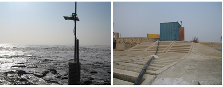
The observation station of navigation satellite reflect signal in Tianjin: In 2014, a research team of the reflect signal of navigation satellite system sets up an observation station of sea ice near the coast of Han Gu district in Tianjin. The height of receive antenna is about 4.5 m, and the azimuth of the antenna about 120° (Figure 1). The antenna is consisted of five units to receive the reflect signal of navigation satellite system, which are direct signal unit, right-handed reflect signal unit, left-handed reflect signal unit, vertical polarized reflect signal unit and horizontal polarized reflect signal unit. The processing system of reflect signal is accommodated in the observation room (Figure 2). The system's hardware device can receive five signals corresponding to the five antenna units. The software system has the data auto-process function, and can receive the Bei Dou and GPS reflect signals simultaneously. At the same place, the video cameras on the roof of the observation room are installed to record sea ice environment near the receive antenna. Because receiver of the reflect signal of navigation satellite system has been improved due to add the vertical and horizontally polarized signal units, the receiving information of the reflect signal have been enriched. The improvement is beneficial to retrieve thickness of sea ice.

(A) Antenna. (B) Equipment
The research achievement of monitoring sea ice with navigation satellite reflect signal:
The observation experiment of the reflect signal of navigation satellite system shows that the technique can achieve the retrieve depth of sea ice, Especially in the worst marine environment which humans cannot touch. The technique with reflect signal of navigation satellite system has great development potential to monitor sea ice, and will be an ideal tool of remote sensing to monitor changes of sea ice for long time. But the theory and algorithm of the retrieval depth of sea ice need to improve. Monitoring ocean with the reflect signal of navigation satellite system is a new field of ocean remote sensing which attracts attention to scientists. In future, navigation satellite system will provide abundant and free signals for monitoring ocean.
The observation experiment of the navigation satellite reflected signal shows that the technology can achieve the retrieve depth of sea ice. Especially in the worst Marine environment that humans cannot touch, the sea ice monitoring with navigation satellite reflect signal has great development potential. It will be an ideal remote sensing technology to monitor sea ice changes for long time. But the theory and algorithm of the retrieval depth of sea ice need to be improved. Monitoring ocean with navigation satellite reflect signal is a new field of ocean remote sensing which is attracting the attention of scientists. In future, navigation satellites can provide abundant and free monitoring signals of sea ice.
Author thanks Professor Li Huang and Cao Yunchang for the instruction.
The works are financed by the Doctor Fund of Tianjin Meteorological Bureau and the fund of Shanghai Ocean University.

©2017 Wei. This is an open access article distributed under the terms of the, which permits unrestricted use, distribution, and build upon your work non-commercially.