International Journal of
eISSN: 2576-4454


Research Article Volume 6 Issue 3
1Department of Geological Engineering,National University of San Marcos - UNMSM, Peru
2Geological, Mining and Metallurgical Institute - INGEMMET, Peru
Correspondence: Jorge Chira, Department of Geological Engineering, National University of San Marcos, Germán Amezaga avenue, Lima, Peru, Tel 51987934591
Received: May 28, 2022 | Published: June 7, 2022
Citation: Chira J, Vargas L,Castañeda D, et al. Surface water quality and geogenic process in the quillcayhuanca and shallap streams, Huaraz-Peru. Int J Hydro. 2022;6(3):119-125. DOI: 10.15406/ijh.2022.06.00311
This research developed because, given the evidence of previous studies, it is necessary to determine the chemical quality of the water in the Quillcayhuanca and Shallap streams, which surround the city of Huaraz on its way to the Santa River, on the western slope of the Cordillera Blanca in Peru. In this sense, the investigated area is located at altitudes between 3524 m.a.s.l. and 4174 m.a.s.l. Twenty-four surface water samples were collected and analyzed for anions, metal, and total cations at the INGEMMET laboratory, Geological, Mining, and Metallurgical Institute of Peru. Likewise, geological mapping was carried out to identify the mineralized and chemically altered areas, evidencing the significant presence of sulfides (pyrite). The waters of the streams have been characterized as magnesium calcium sulfate, with SO4= anion contents of up to 181.10 mg/L in the Quillcayhuanca stream and 78.8 mg/L in the Shallap stream. Likewise, for both streams, an oxidized acid environment has been determined.
The oldest stratigraphic unit corresponds to shales and sandstones of the Upper Jurassic Chicama Formation. The igneous rocks are made up mostly of granodiorites and tonalites corresponding to the Batholith of the Cordillera Blanca from the Neogene-Miocene. The Quaternary is represented by glacial, glacial fluvial, morainic and fluvial deposits. Regarding the chemical quality of the water, some elements exceed the environmental quality standards (ECA) for "Surface water intended for the production of drinking water" such as Al, Fe, and Mn. These elements are due to geogenic factors, given the presence of sulfides in the exposed rocks in the upper parts of the ravine plus the alteration of aluminosilicates in the exposed rocks.
Keywords: Water quality, surface water, environmental impact, geogenic factors, hierarchical cluster
Huaraz, a city located in the Peruvian Andes, uses water from the Cordillera Blanca. Two of the streams that transport this water, Quillcayhuanca and Shallap (Figure 1), show oxidation and heavy metal content. For this reason, it is necessary to characterize the source that is negatively impacting water quality. The headwaters of the ravines form part of the Huascarán National Park, considered an intangible zone to carry out any anthropic activity.
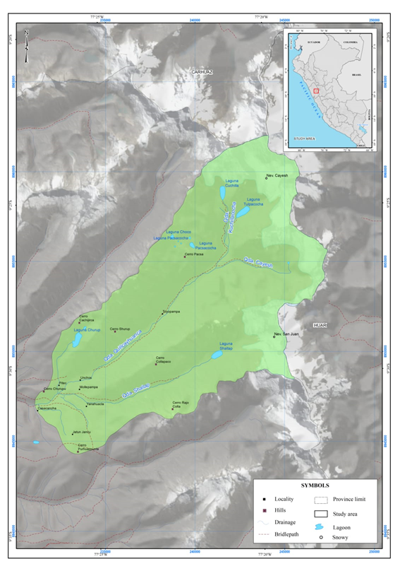
Figure 1 Location of the investigated area. The Quillcayhuanca and Shallap streams are tributaries of the Santa River, which supplies water to the city of Huaraz, located in northern Peru.
The main activities carried out involve the geochemical sampling of surface water from the headwaters to the confluence of both micro-basins, the reading of physicochemical parameters of the water in 24 sampling stations, and the geological mapping of alterations and mineralization.
The recognition of the geology, mineralization, and alteration of the study area, also the collection and chemical analysis of surface water samples, made it possible to determine the type of surface water and the presence of heavy metals in the Quillcayhuanca and Shallap streams. The analytical results obtained compared with the Environmental Quality Standard (ECA) for category 1 water and subcategory A1 water that can be made drinkable with disinfection, regulated by Supreme Decree No. 004 2017-MINAM,1 to determine the chemical quality of the water. The investigation results allow us to contribute to the knowledge of the environmental impact due to geogenic factors in surface waters, considering that there is no anthropic activity in the headwaters of the Quillcayhuanca and Shallap streams.
The explanation for the color change in surface water and its relationship with the iron content was investigated by Kritzberg et al.2 determining its conditioning to redox conditions. Likewise, Sheng et al.3 applied the Principal Component Analysis (PCA), considering water quality parameters, and integral contamination indices, identifying contaminated tributaries. Multivariate statistical techniques were also applied by Zhang et al.4 managing to identify types of pollution sources, and better understanding the Spatio-temporal variations in water quality. In addition to PCA analysis, Xu et al.5 applied Fuzzy Comprehensive Evaluation (FCE) in the water quality of a lake in China. Likewise, Zhaoshi et al.6 evaluated the quality of the river, using the water quality index, through the most relevant parameters, classifying the water quality as "moderate". Along these lines, Tyagi et al.7 proposes the application of a new water quality index, accepted worldwide in a simplified format, that can be used reliably in environmental assessment.
On the other hand, in relation to the effect of geogenic factors on water quality, Baba & Gündüz8 identified the threat posed to health by the oxidation of pyrite in altered volcanic rocks that gives rise to extremely acidic waters. Likewise, Kushawaha and Aithani9 refer to geogenic contaminants in groundwater, among which they identify iron and manganese.
For their part, Bell, Bullock, and Geldenhuis10 had already addressed the impact of acid drainage, particularly that derived from the oxidation of sulfide minerals such as pyrite, its products being ferric and ferrous sulfates. Likewise, Cao et al.11 based on sequential extraction and electron microscopy studies in pyrites, determined that FeS2 was the main mineral that contained relatively enriched toxic heavy metals.
In Peru, Ccanccapa et al.12 evaluated the health risk of dissolved metals in surface waters in the south of the country, determining that, in addition to boron and arsenic, other elements such as Al, As, B, Mn, among others, show values of significant concern for the environment.
Geology
The study area is made of lithostratigraphic units of ages that vary from the Upper Jurassic to the Quaternary (Figure 2), the latter occupying the ravines and surroundings of the lagoons. Likewise, the Jurassic formations are intruded by the igneous rocks of the Batholith of the Cordillera Blanca. Three geological units stand out, which are described below.
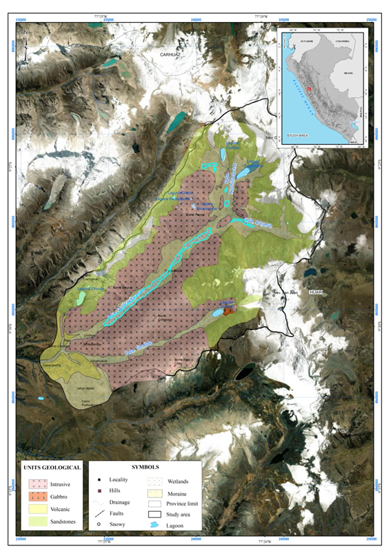
Figure 2 Geological units. In the study area, three geological units stand out: Chicama Formation (Jurassic), Lloclla Formation (Quaternary), and the Cordillera Blanca Batholith.
Chicama formation
In the study area, this formation is represented by a sedimentary series made up of fine to very fine-grained white quartz sandstones at the base; followed by gray sandstones of fine to very fine grain, with intercalations of dark gray shales and eventual levels of carbonaceous shales towards the east and southeast of the Kuchillacocha and Cayesh creeks. It is in contact with the syenogranites of the Cordillera Blanca, being instructed by dacitic and andesitic dikes. The fine-grained gray sandstones show strong pyritization (up to 10%), and patinas of iron oxides, predominantly goethite, are associated with bedding planes, as well as discontinuities. On the other hand, there are strata up to 2 m thick of white quartz sandstones, slightly recrystallized, interspersed with dark gray to black lutaceous levels with thicknesses between 5 and 20 cm.
Lloclla formation
It consists of fluvioglacial deposits found in the glacial plateau extended between the Cordillera Negra and the Cordillera Blanca, on the right flank of the Santa River.
This formation denotes the clastic sedimentary fill type belonging to the intramontane basin of the Callejón de Huaylas. It is where deposits correspond to the erosion phase of the Cordillera Blanca uplift. It denotes by presenting consolidated strata of fluvioglacial deposits, which contain clasts of intrusive rocks for the most part and clasts of volcanic origin to a lesser extent.
Cordillera blanca batholith
It is predominantly made up of coarse-grained syenogranites, which have weak subhorizontal foliation and, like the Chicama Formation, are intruded by dacitic and andesitic dikes trending NNW-SSE. Likewise, in the Shallap creek, the presence of a slightly chloridized gabbro (possible mega xenolith) was evidenced. These intrusives present a weak quartz veinlet and centimetric aplitic veinlets (up to 5 cm wide) in the ravine.
Alteration in rocks
The predominant alteration is a moderate to strong silicification, both in the intrusive rocks of the Cordillera Blanca batholith, andesitic and dacitic dikes; as well as in the sandstones and shales of the Chicama Formation, which in turn show strong limonitization in contact with intrusive rocks and NNW-SSE fault systems, as well as moderate to weak recrystallization. Likewise, the presence of biotite and chlorite hornfels in contact with the intrusive rocks, accompanied by weak to moderate disseminated pyritization, is evident.
On the other hand, as a result of the glacial retreat in the upper part of the Quillcayhuanca and Shallap ravines, the sandstones of the Chicama Formation are exposed, which present pyrite, which when are altered gives rise to the formation of iron sulfates, oxides, and hydroxides. These mineral species interact with the surface water, giving it considerable contents of iron, sulfur, and sulfate, which in some cases exceed environmental quality standards. The impact of geogenic processes on the quality of surface waters denotes it.
Mineralization
The rocks of the study area, especially the quartz sandstones, present disseminated mineralization. However, this mineralization is not economical due to the scarce presence of ore minerals (Figure 3). One of the principal evidence of mineralization occurs in the headwaters of the Quillcayhuanca and Shallap ravines, specifically in the fine gray sandstones of the Chicama Formation, which show fine dissemination of pyrite, up to 10% (Figure 4). Likewise, in boulders of fine-grained sandstone from the Shallap creek, veinlets of pyrite and subhedral galena have been evidenced, with abundant patinas of goethite and turgite.
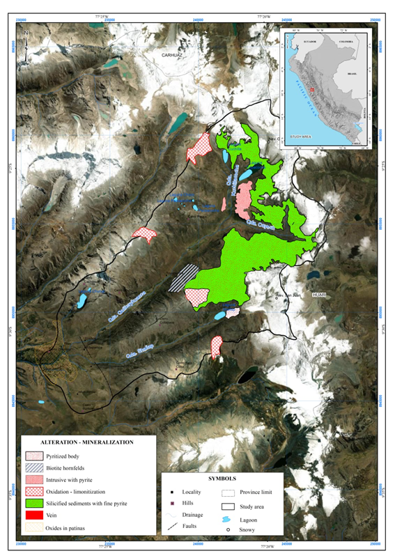
Figure 3 Alteration and mineralization. A moderate to strong silicification predominates in intrusive rocks, in addition to fine dissemination of pyrite (up to 10%) in sedimentary rocks.
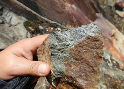
Figure 4 Recrystallized sandstones with abundant disseminated mineralization of fine pyrite, Shallap stream.
On the other hand, an old artisanal type mining exploration has been recognized, 80 cm wide and approximately 5 m deep, which follows a brecciated structure made up of hyaline quartz, pyrite, and goethite, associated with N-S strike faults in the confluence of the Cayesh and Kuchillacocha streams (Figure 5).

Figure 5 Mining survey 80 cm wide and approximately 5 m deep. The confluence of the Cayesh and Kuchillacocha streams.
In addition, ferricrete associated with intercalations of pyritized gray sandstones with gray shale is found, in contact with the NNW-SSE fault systems. Likewise, patinas of jarosite, goethite, and Fe sulfates are in the planes of discontinuities (Figure 6). As for the intrusives of the batholith of the Cordillera Blanca, these present weak dissemination of pyrite + chalcopyrite, increasing towards the contact with the sedimentary rocks. Likewise, it is possible to find veining (centimeter) of quartz and aplitic veinlets.
Twenty-four surface water samples were collected (Figure 7) also two field duplicates. In the collection of samples, polyethylene bottles with double lids were used. The samples were preserved with nitric acid (1:1) to ensure a pH lower than 2. The determination of metals was performed using the ICP-MS and ICP-OES techniques.

Figure 7 Location of water samples. The sampling design considered stations along the Quillcayhuanca and Shallap streams, collecting approximately 24 samples and obtaining one for each kilometer of runoff.
ICP was developed for optical emission spectrometry (OES) by Wendt and Fassel at Iowa State University in the United States and by Greenfield et al. at Albright & Wilson, Ltd. in the UK mid-1960s.13
Inductively coupled plasma (ICP) mass spectrometry (MS) is one equipment used in various research fields, such as earth sciences, food, chemical materials, nuclear industry, and others. The high density of ions and high temperature in a plasma provide an ideal medium for atomization and ionization for all types of samples and matrices introduced by specialized devices.14
At each surface water geochemical sampling station, in-situ readings were taken of the main physicochemical parameters of the water. For this, was used the HANNA model HI9828 multiparameter equipment. The parameters recorded were: pH, electrical conductivity (EC), total dissolved solids (TDS), temperature (T), dissolved oxygen (DO), salinity, oxidation-reduction potential (ORP), pressure, and resistivity. Based on the data obtained, the physicochemical conditions of the geological environment through which the surface waters flow were determined.
The geological mapping was carried out by recording the geological, structural, mineralization, and alteration data of the study area, having collected 26 samples of rocks and minerals to carry out various studies in the INGEMMET laboratories.
Instruments and reagents
The content of heavy metals in surface water samples was determined using the ICP-MS equipment, Perkin Elmer model Nexion 300D, and ICP-AES, Agilent Technologies model 735-ES.
The samples were digested in the laboratory of the Geological, Mining and Metallurgical Institute of Peru, using high purity nitric acid (60-62%) and high purity hydrochloric acid (30-32%) using a hot block digestion system. (SCP Science DigiPREP), under controlled conditions of pressure and temperature, according to the methods of the Environmental Protection Agency (EPA), 200.7, determination of metals and trace elements in water and wastewater by inductively coupled plasma atomic emission spectrometry,15 and EPA 200.8 determination of metals and trace elements in water and wastewater by inductively coupled plasma - mass spectrometry.16
The chemical quality of the water is referred to by the National Environmental Quality Standards for Water (ECA) in category 1 (population and recreational use).
Physicochemical parameters in surface waters
Hydrogen potential (pH)
In the Quillcayhuanca creek, the values fluctuate between 3 and 3.8, while in the Shallap creek, the pH is also acidic, varying between 3.6 and 5, in whose bed blocks and pebbles of andesitic rocks with scattered and strongly oxidized pyrite (Figure 8).
Electrical conductivity (EC)
The values in the Quillcayhuanca stream are less than 600 μS/cm. In the Callash sector, strongly oxidized shale outcrops from the Chicama Formation, and on both banks, some wetlands are orange in color due to oxidation. In the Shallap creek, the values are less than 300 μS/cm.
Dissolved oxygen (DO)
In the Quillcayhuanca creek, six values below 4ppm occur, so they do not meet the requirements of the category A3 water quality standard for use. In the Shallap creek, according to the range established in the ECA (subcategory A3), four samples were determined that do not reach the minimum value for said category.
Total dissolved solids (TDS)
Establishing as a base the value in the ECA (subcategory A1), it is observed that the samples of the Quillcayhuanca creek do not exceed said value. According to the 2017 guide prepared by the WHO, World Health Organization, the level of TDS in water less than 300 ppm is considered excellent; Furthermore, the Shallap creek shows TDS contents lower than 150ppm.
Chemical characterization of the Quillcayhuanca and Shallap micro-basins
The waters of the Quillcayhuanca Shallap streams are classified as calcium magnesium sulfate (Figure 9). In the upper sector, the intrusive units of the Cordillera Blanca Batholith and the strongly oxidized sandstones of the Chicama Formation predominate.
Chemical quality of the water
Since the conditions of the surface waters of both streams are acidic, in an oxidizing environment, aluminum, iron, and manganese behave as mobile elements, reaching concentrations higher than those established by the environmental quality standard (ECA).
Aluminum
The limit established for aluminum for subcategory A1 (Water that can be treated with disinfection) is 0.9 mg/L. In this sense, fourteen 14 samples from the Quillcayhuanca creek greatly exceed this value (Figure 10).
Likewise, in the Shallap stream, all the values exceed the limit established in the standard (Figure 11).
Iron
The highest concentrations of iron were recorded in the Cayesh stream (16.35 mg/L and 16.33 mg/L), a first-order tributary of the Quillcayhuanca stream, which exceeded the value of the ECA (0.3 mg/L) by up to 53 times (Figure 12). In this sector, intense oxidation is evidenced in the wetlands and fluvial boulders. Similarly, along the Shallap creek, iron concentrations higher than the ECA were observed (Figure 13). The maximum concentrations were identified in two sampling stations, where andesite boulders with scattered pyrite were observed, in addition to heavily oxidized granodiorite boulders.
Manganese
Except for one station, manganese showed concentrations higher than the ECA (0.4 mg/L) in the surface waters of the Quillcayhuanca stream (Figure 14). The surface waters of the Shallap creek, although to a lesser extent, also present concentrations higher than the ECA value (Figure 15).
Geochemical associations
The principal geochemical associations, the hierarchical cluster analysis was applied to obtain the geochemical variables with the highest contrast, including the main physicochemical parameters taken in the field.
The hierarchical cluster analysis allows for identifying groups of variables, in which those of the same group must be the most similar to each other and the most dissimilar to others of different groups.17 The variables are located in clusters with centroids that summarize the information of said clusters, providing an overview of the structure of the processed data.18
The sharpest geochemical association is made up of electrical conductivity, total dissolved solids, SO4=, S, Mg, Mn, Ca, Ti, Sr, and Li (Figure 16), which suggests that is a component related mainly to relatively conductive salts, such as sulfates from the chemical alteration of sulfides.
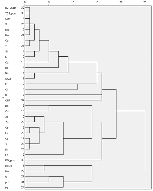
Figure 16 Dendrogram of the main geochemical variables. The cluster that denotes the highest affinity conformed to CE, TDS, SO4=, S, Mg, Mn, Ca, Ti, Sr, and Li, followed by the cluster Al, Zn, Fe, Ce, La, Co, Y, and Ni.
Next in importance is the association composed of Al-Zn-Fe and Ce-La-Co-Y-Ni (Figure 16). The metallic character of this association is evident and linked to a certain extent to lithophilic phases.
To the authorities of the Geological, Mining and Metallurgical Institute - INGEMMET, for their support in the development of this research.
There are no conflicts of interest.

©2022 Chira, et al. This is an open access article distributed under the terms of the, which permits unrestricted use, distribution, and build upon your work non-commercially.