International Journal of
eISSN: 2576-4454


Research Article Volume 6 Issue 4
Departamento de Ecología Humana, CINVESTAV-IPN (Mérida), Km 6 Old Highway to Progreso, Merida, Yucatan, C.P. 97310, Mexico
Correspondence: Eduardo Batllori Sampedro, Departamento de Ecología Humana, CINVESTAV-IPN (Mérida), Km 6 Old Highway to Progreso, Merida, Yucatan, Mexico. C.P. 97310, Tel 9992-71-33-98
Received: August 01, 2022 | Published: August 15, 2022
Citation: Sampedro EB, Patrón JLF. Hydrology of the palmar state reserve, yucatán, México: hydrological budget of petenes. Int J Hydro. 2022;6(4):159-161. DOI: 10.15406/ijh.2022.06.00320
Throughout the coastal zone of Yucatan state (Mexico), between the coastal sandbar, and the land with low dry forest, are the flooded low forest, mangroves, and swamps. It is within these swampy lands, where are found numerous arboreal islands or petenes (local name). It has been outlined that its importance is because the water contribution from springs to the basin. As a contribution to the knowledge of the petenes, it was developed a hydrological monitoring system to estimate the hydrological budget of a petén located 3 km southwest of the population of Sisal in the restoration zone of the Palmar Reserve, Yucatan. The analysis showed that the groundwater inflow represented 92 % of the total of inflow to the system, with the net precipitation representing only 6 % and the surface inflow 2 %. By the other side, the surface outflow represented 40 % of the total of the outflow of the system, the groundwater outflow 20 % and the evapotranspiration 40 %. The annual total balance resulted negative (it means fluxes out of the petenes) with a volume from storage of about – 129,288.28 m3. The springs in the interior of the petenes can become more determinant in the hydrologic balance of the community than the contribution of the pluvial precipitation, the hydrodynamics of swamps, or the influence of the waters of the sea.
Keywords: karstic aquifer, tropical zone
The peninsula of Yucatan presents a particular hydrology due to its geological origin and karstic nature. These characteristics do not permit the rivers establishment; however, it exists an underground aquifer that flows to the coastal zone through springs. This affluence of water provokes the transformation of the coastal depressions in wetlands.1 throughout this basin, between the sandy coastal bar that form the beaches, and the land with low dry forest, are the flooded low forest, mangroves, and swamps. It is within these swampy lands, where are found numerous arboreal islands or petenes (Figure 1).

Figure 1 Schematic view of northwest coastal wetlands at Yucatan, Mexico.2
The primary condition for the origin of a petén is the emergence of a substrate within swamp, so that it will be possible the invasion by plants that normally are not developed in these areas. This substrate can be the result of several phenomena related with some geologic, hydrological, topographic, or biological character. The different origins can be by differences in the relief of the soil, by the presence of springs, and by soil accumulation due to aquatic plants. The changes in the petenes could be directed by a series of extrinsic and intrinsic factors to the community, which act through the time. In this way the evolution of the petenes is going from simple communities as the mangroves, until those most complex formed by jungle elements (Figure 2).

Figure 2 The evolution of the petenes is going from simple communities as the mangroves, until those most complex formed by jungle elements.
The degree of complexity of the vegetable community, that is considered as an attribute of the evolutionary time, is going in direct relationship to geological time, which determines some characteristic as the distance to the sea, the increase of the soil and consequently, the degree of flood and salinity.3
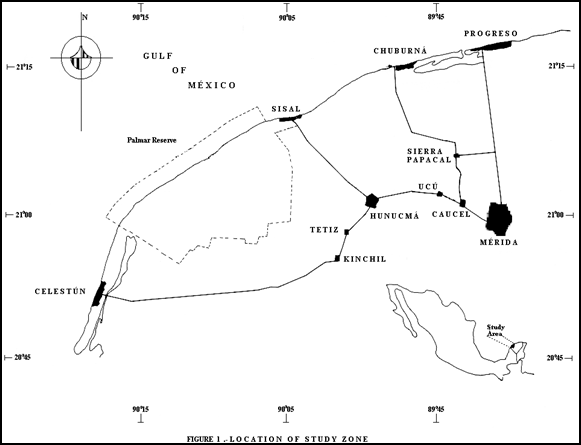
In the Manage Program of the Palmar Reserve, is located the system of petenes as a critical area for the operation of the hydrological basin. In terms of its vegetable coverage, the petenes occupy a small percentage of the total of the Reserve (6.8 %), however, it has been outlined that its importance is because the water contribution from springs to the basin.4 As a contribution to the knowledge of the petenes, it was developed a hydrological monitoring system to estimate the hydrological budget of a petén located 3 Km. southwest of the population of Sisal in the restoration zone of the Palmar Reserve, Yucatan (Figure 3).

Figure 3 Location of study zone.5
It was developed a conceptual model in which are located each one of the compartments that describe the inflow and outflow of the water in a peten (Figure 4):
An automatic hydrological monitoring system was installed to measure during a year the pluvial precipitation, net precipitation measured by the stemflow and throughfall, environmental temperature and relative humidity, fluctuation of the water level and groundwater flow, and the climate records of Sisal, and tide of the port of Progreso. It was accomplished a soil analysis and the topographic leveling of the petén and the swamp (Figure 5).
To estimate the groundwater inflow, it was used a batimetric map, and a trigonometrical formula to know the volume,6 obtaining the flow in time according to the variation on the water level. The groundwater outflow was calculated on relation to the decrease in the water level over time, considering the corresponding volume as reflux. The surface outflow was estimated according to the values of the water level in the spring and the topographic level of the petén, considering the water level above of the soil as the volume of water that flows to the swamp. The surface inflow was estimated considering the values of the water level in the swamp above of the water level in the petén as the volume of water that flows from the swamp to the petén. The potential evapotranspiration was estimated through the environmental temperature of the petén and using the formulation of Thornthwaite widely recommended for studies in wetlands.7
The hydrological balance of the petén was estimated from a data collection from January to December of 1996. The climate in Sisal presented an average air temperature of 26 oC with a maximum and minimum of 28 and 23 oC respectively, with a total precipitation of 374 mm and a total evaporation of 1,756.5 mm. southward, in the zone of recharge of the aquifer the total precipitation and evaporation was of 921 and 1,600 mm respectively. The petén has a diameter of 291 m with an area of 66,508.5 m2 and a depth of the organic soil of approximately 1.5 m.
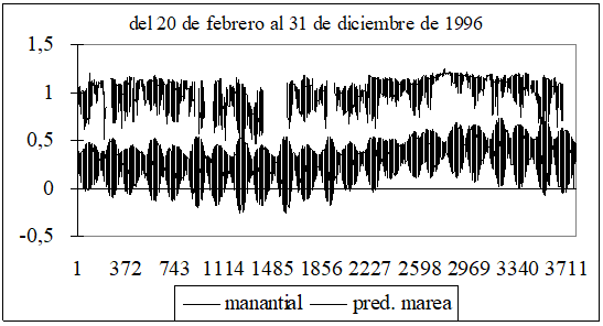
The variation of the water level in the spring and tide presented a high hydraulic association with a value of correlation of 0.8 with 99 % of significance (Figure 6).

Figure 6 Variation of the water level in the spring and tide in petén Pila, from february 20, to december 31 of 1996.
Exist three components that affect the hydrology of the petenes: 1) the hydrodynamics of the swamp, 2) the water of the rain and 3) the freshwater flow from springs. The analysis showed that the groundwater inflow represented 92 % of the total of inflow to the system, with the net precipitation representing only 6 % and the surface inflow 2 %. By the other side, the surface outflow represented 40 % of the total of the outflow of the system, the groundwater outflow 20 % and the evapotranspiration 40 %. The annual total balance resulted negative (it means fluxes out of the petenes) with a volume from storage of about – 129,288.28 m3. The springs in the interior of the petenes can become more determinant in the hydrologic balance of the community than the contribution of the pluvial precipitation, the hydrodynamics of swamps, or the influence of the waters of the sea (Figure 7).
The underground aquifer of the northwest region of the Yucatan peninsula, is recharged by the rainfall occurred in the continental part and because the high permeability of the land surface, as well as the slope of the continental relief, groundwater flows toward the coast, where the aquifer is confined by a layer of waterproof material (calcrete layer). Springs occur in those points where this barrier is interrupted.1 The flow and the water level of these springs have seasonal variations caused by the contribution of the continental aquifer, that varies in function of the recharge by rainfall. The flow rates are quite variable. A flow greater than 7 m3/s was measured in a petén near Chuburná Port.8 Also occur variations in the daily, monthly and annual fluctuation of the hydrostatic level and flow as result of the influence of tides.1 The springs in the interior of the petenes can become more determinant in the hydrologic balance of the community than the contribution of the pluvial precipitation, the hydrodynamics of swamps, or the influence of the waters of the sea.
Recently petenes have been important in the rehabilitation of the coastal wetlands that have been damaged basically by the highways and ports construction. The deterioration of mangrove zones has been attributed to the obstruction of the water flows and the entrance of salwater. In this way, the springs of the petenes, have been seen as an alternative to help to reestablish the hydrological conditions of these wetlands.4 It is necessary to develop more deep studies about soils, hydrodynamics, population behavior of vegetable species, as well as about relationships of the petén with the communities between them. This information would give us the opportunity to understand how the community operates, and in this manner, to use and protect this resource in a more adequate way.9
None.
The author declares there is no conflict of interest.

©2022 Sampedro, et al. This is an open access article distributed under the terms of the, which permits unrestricted use, distribution, and build upon your work non-commercially.