International Journal of
eISSN: 2576-4454


Short Communication Volume 3 Issue 4
Universidad Autónoma de Ciudad Juárez, México
Correspondence: David Zuñiga de León, Department of Civil Engineering and Environment, Juárez City University of México, Del Charro Avenue, México
Received: July 24, 2019 | Published: August 5, 2019
Citation: león DZD, Domínguez IHM. Fault between cuchillo fm. units as a water source of El Pozito spring. Int J Hydro. 2019;3(4):279-284. DOI: 10.15406/ijh.2019.03.00190
"El Pozito" spring has been the source of water consumption during 50years by nearby communities of Juárez city, México therefore, it can be said that it is perennial. The present research is concerned on two main features needed to assess the Hydraulic Conductivity of El Pozito. Firstly, Lithological units of (Kcu and Kb Fms.) were the location of a big fault documented here named El Pozito. Secondly, highly permeable conglomeratic units of Cuchillo units are the perennial source of water so would be the future key to research hydraulic conductivity. Summarizing, this short communication focus in the Fault, researching the lithological units which were able to store and translate water. Previous geological features are mentioned in.1
Keywords: spring, perennial, fault, hydraulic conductivity, conglomeratic.
Three geological formations as the key to understand El Pozito spring are presented here: Cuchillo (111m), Benigno (112m) and Mesilla valley (20m). Cuchillo lower (Kcl) is composed of three units; One, interbedded dark-gray limestones, shales and yellow-brown calcareous quartz-sandstones. Other, red-yellow to brown packstones Ostrea banks and quartz sandstones, maroon shales with green micrite nodules 47m thick. Another, at the base of the middle member are typical of unit three, it also contains a limestone bed with many gastropods, silicified wood and packstone similar to unit three. Cuchillo middle member is 8m thick (Kcm), it is composed of chert conglomerate and a coarse white quartz-sandstone which grades upward into packstone, bellow the base of this member. Unit 5 is composed of a light gray, massive bedded, ridge forming bio-stromal reef limestones with colonial coral heads and razor clams. Finally, the upper member of Cuchillo Fm (Kcu 64m thick) is composed mainly for unit 6. These unit is highly permeable and consists of reddish brown hematite pigmented fragments of cross-bedded quartz pebble conglomerate and coarse sandstones overlain by brown oolitic limestones (2m to 8m thick). The lower contact of unit 6 is the Aptian-Albian boundary. Unit 7 consists of Olive-gray shales and interbedded yellow limestone. Unit 8 consists of thin bedded light gray shales, blue-gray limestones and gray marls, this is the base of Benigno Formation (Kb). Kb is a cliff (10-80m thick) of massive bedded bio-stromal, bio-hermal, rudistid reef limestones which graduates upward into wackstones and packstones. This member forms massive cliffs in thrust sheet III, cliffs reduce in height as thickness decreases in lower thrust sheets. A marker bed of gray-green mottled limestone with black and brown chert nodules occurs 2m below the top of middle member (Kbm). This member has 21meters of light gray-blue to medium dark gray limestone and green-black limey shales. The upper member (Kbu) is a 21meter of orbitolina sp packstones and wackstones alternating with shales, this member, has 7m of orbitolina sp packstones, however, their contact is difficult to map because of the lithological similarity of the upper member of the Benigno to the lower member of the Lagrima Fm. Mesilla Valey Fm (Kmv) is primarly shale with two units. One lower carbonaceous black shale and an upper (Kmv) shale with siltstone, fossiliferous limestones and near the top fine-grained ferruginous sandstones (these units are between 2 to 10meters thick).2-4 Summarizing, the hydrogeological behaviour of El Pozito spring is based on four aspects; First, in the (Kbl, Kcm) are the permeable units which transport the water stored during Cabeza de Vaca lake. This Plio-Pleistocene lake filled the study area until 1300masl; Second, in the Kcl and Km are, the impermeable units which store and confine the water which is the source of El Pozito spring; Third, 56m thick of the upper fractured units controls the stored Cabeza de Vaca water as well its recent recharge which is derived from all the formations including Kb already discussed, the Big fault found on the study area is the contact of unit 6 of Cuchillo medio (Kcum) and the unit 8 which corresponds to Benigno Lower (Kbl).2-4 Moreover, Digital Elevation Models (DEM) is used to assess contour curves levels offset 1m (Figures 1‒3).
East potrillo (EP) (New Mexico) and Juárez mountains (JM) lithology correlation
Due to their proximity (40kms), there are many similar structural and sedimentation features between EP and JM. Cretaceous spatial and temporal lithology are common for both mountains. Moreover, Aptian to Albian times Cuchillo (Kcu) were deposited, in a similar depositional environment. However, depending on topography, thickness of lithological units would be different. In the study area (JM) (Cuchillo Fm) lower, middle and upper is compared with (EP)
(Hell-to-Finish and U-Bar Fms).5 stated, that Cuchillo (Kcu) as well Benigno (Kb) were middle Aptian to lower Albian. However, in (EP) the (Hell-to-Finish unit) is divided into two members, conglomerate member (ha) and an overlying mottled siltstone member (hb), bellow these units, there are (Las Vigas Fm). Las Vigas Fm (important to address El Pozito Spring) outcrops (JM) and is composed mostly of dolomitic, limestones and siliciclastic fragments. So maybe would be the base of Cuchillo Fm. In the study area, 2m of pebble quartz sandstone conglomerates are common and outcrops in contact with oolitic limestone and packstones of Lower Cuchillo Fm. On the other hand, the (EP)(U-Bar unit) is divided into six members and their lithology is congruent with the Cuchillo Formation on the study area. However, due to fault Hanging wall compress the rocks and reduced its thickness, Then only 53meters of Cuchillo outcrops at the Posito spring as a result of this fault. Also, the Benigno (Kb) is composed mostly of siltstone and limestone in supra massive reef (Kbl) as well limestones with 1m or 2m in infra reef (Kbu). The differents units, distributed on the U-Bar are congruent with the middle and upper Cuchillo (Figures 1-3). The lowest cretaceous rock is: Las Vigas (82m of shale and limestone overlying by Cuchillo Formation which is formed by a lower clastic unit a middle carbonate unit and an upper clastic unit.6,7 Cuchillo is similar to the mottled siltstone, lower limestone, and sandstone members in the EP mountains.8

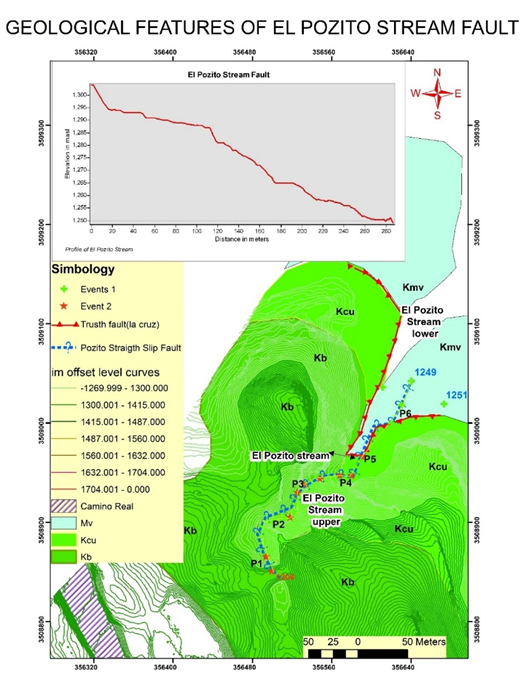
Figure 2 Graphic shows stream profile from P1 to P4; Distance of 250m axe (x) and elevation (masl); thrust fault in red and lateral strike slip fault in blue, also lithological contacts between Kcu, Kb and Kmv formations. Events 1 green cross are lithological contacts between Kcu and Kmv Fms. Events 2 red stars points of fault (blue colour). Figure 1. Lithological column of Cretaceous Lower, medium and upper (Kcul, Kcum, Kcuu) in the fault area, This section is the thinnest section of both Cuchillo and Benigno are in contact by fault; as you see in A, the profile is nearly 59m thick.

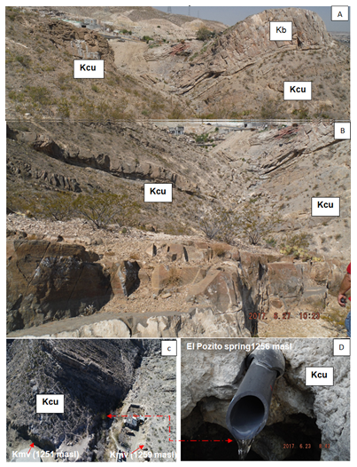
Figure 3 Images A, B and C shows from SW47 to NE43 the failure blocks: (A) (Kb) Benigno Lower sliped over (Kcu) Cuchillo medium; (B) Shows, the little change in trajectory from SW45 to NE 45 as well the contact between Cuchillo lower and medium with Benigno Upper. (C) Cuchillo Upper in contact with Kmv. Finally in (D) El pozito pereene Spring.
The red-yellowish brown siltstone, sandstone and silty-limestone of middle Cuchillo units as well siltstone and very fine to fine grain calcareous sandstone suggests a shallow-marine sedimentation process. Additionally, the siltstone and sandstone are massive, horizontally laminated and cross-bedded. These features are typical of modern sediment derived from the Atlantic and Gulf continental shelves of the United states.9,10 Horizontally laminated siltstone and sandstone, as well shale, where probably deposited from suspension during fair-weather periods and were not resuspended by storms. On the other hand, massive siltstones and sandstones may were deposited from suspension, or may have been deposited originally by storms and then reworked by burrowing organisms. The evidence from the fine grain facies suggests deposition between normal wave base and storm wave base, depths that can vary between 15m and 200m.6,11
In General, three tectonic events deformed the JM and El Pozito area during Late Cretaceous to Cenozoic period. Firstly, The Cruz oldest thrust and their associated drag folds was occurred during Laramide Compressive event in late Cretaceous-early tertiary time. After that, during late Oligocene-early Miocene Rio Grande rift extension event rocks were dissected and rotated by low angle normal faults. Finally, a high angle normal faults cuts middle tertiary and quaternary strata and the modern relief of fault blocks were resulted such as: Graven and horst blocks, which created so many basins and associated stream systems. Particularly, el Pozito spring is located in the oldest thrust. The path direction of the (Kcu-Kmv) thrust is variable: (NW45-NW25 to NW80-W-NE20) but in the surrounding area, the thickest section begins nearly 2km eastward from El Pozito spring forming a lower bordered confined sheet. Therefore, Cuchillo terminates in El Pozito spring which has the lowest lithological thickness section (53m). Moreover, water laid conglomerate is perhaps its water source. During, Basin and Range province and Rio Bravo rift many normal faults were developed forming the basin and associated stream system like Stream El Pozito (Figures 1-4).

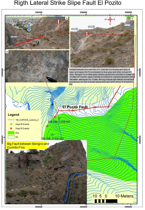
Figure 4 Shows the main features related to the fault. A) Shows fault length in scale as well the travel fault in vertical scale see the countor levels offset 1 (blue lines). Gray arrows in images A and C shows 2m scarps located in the upper member of Benigno and medium member of Cuchillo and image D shows a big scarp Benigno Lower member in contact with Lower and Medium members of Cuchillo Formation (biggest Fault dashed blue curve line). In image B Shows the marked fossils of Packstones of Benigno Formation.
None.
The author declares that there is no conflict of interest.
None.

©2019 león, et al. This is an open access article distributed under the terms of the, which permits unrestricted use, distribution, and build upon your work non-commercially.