eISSN: 2576-4462


Research Article Volume 7 Issue 1
Promotion, Research and Development Unit, Landscape Engineering (UPID-IP), Faculty of Agricultural and Forestry Sciences, National University of La Plata, Argentina
Correspondence: Prof. Rubén Opel. Faculty of Agricultural and Forestry Sciences, School of Forestry, Avda 60 N, CP 1900. La Plata. La Plata, Argentina
Received: March 03, 2023 | Published: March 20, 2023
Citation: Opel R. Associated territorial management, the way to transform the periurban area into a green belt. Horticult Int J. 2023;7(1):14-19. DOI: 10.15406/hij.2023.07.00270
La Plata, like all cities, based its territorial organization -and landscape- on the construction of an inhabited area surrounded by productive green rings. Subsequently, like all other urbanizations, growth by extension generated a fragmented and degraded periphery. Currently, the periurban area presents a growing demand, dispute and conflict between different social groups that is beginning to be included in the political and management agenda. The purpose of this paper is to contribute to the construction of a new management model to transform the periurban area into a green belt, as an environmental, economic and social asset for the whole society.
Keywords: Landscape, productive belt, disorderly expansion, disputed lands, territorial strategy, associated management, green belt -productive/recreational
The Ordinances for the Discovery, New Population and Pacification of the Indies are a set of laws promulgated by Philip II in Valsaín, Segovia, on July 13, 1573 and published in full on May 3, 1576 in San Lorenzo de El Escorial.
There, the spatial concept of cities arose, based on the late medieval traditions of construction of cities with a regular plan, brought to America by the conquistadors from Europe. Regular urban patterns such as Castellón de la plana1 and Vila real de los Infantes2 and especially Briviesca and Foncea (15th century).
These Ordinances constituted the organizing framework of the territory in Latin America in the period between 1492 and 1890. This regulation established the framework on the basis of which the towns in Argentina were founded.
The territorial planning scheme consisted of:
In the case of the City of La Plata, it was founded within the framework of the New Population Ordinances and strongly influenced by the prescriptions of the Brighton Congress, England, in 1879, referring to public hygiene to prevent the spread of contagious diseases. The "germ theory" proposed the need for aeration of spaces and greater use of water, the main resource to guarantee sanitation in urban centers.
In this Congress, the outstanding French scientist Dr. Sarrasin, began his speech by saying that "among the causes of disease, misery and death that surround us, there is one to which I consider it rational to attach great importance and that is the deplorable hygienic conditions in which the majority of men are situated". At the same Congress, he proposed the construction of "France Ville, the city of well-being and health".
For Sarrasin, the solution to the serious problems caused by urban agglomerations was to be found in "the most powerful method of persuasion: example", which is why he asked himself: "why don't we gather all the energies of our imagination to draw the plan of a model city, on a rigorously scientific basis?
This "model city", which was to be built in the American territory on a vast unpopulated plain, based on a spatial concept consisting of:
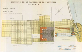
Thus was founded La Plata, a national and international utopia of planning, land use and previous design. Its unique features were:

Julio. City of La Plata: Three decades of reflections on a unique urban space.20
In synthesis, the planning and landscape of the foundational territory was based on a totalizing vision of the territory, and materialized from an inhabited hull surrounded by productive green rings.
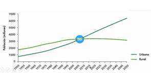
From the 20th century onwards, the world context changed and the urban sphere took precedence over the rural sphere, as a result of:
Thus, in this era there is an unprecedented growth of urbanization.3 even more so in the context of globalization which, with the opening of markets to international exchange -trade, financial flows and technological knowledge- has determined a continuous increase in urbanization rates, reinforcing the processes of population concentration in cities, especially in the formation of large metropolitan areas.4 Figure 2

Figure 2 Inclusive and productive CITY.
a. Since 2007 the world is urban
b. Latin America is urban since 1961
c. Argentina is urban since 1912
The growth of cities in Latin America and Argentina in the last two decades has had the following characteristics:
- Large cities with more than 1 million people concentrate close to 50% of the total urban population and the main city in each country is disproportionately large in relation to the rest. According to the World Bank,5 several of these cities already exceed 20 million inhabitants, such as Mexico City, Sao Paulo, Rio de Janeiro and Buenos Aires.
- The housing shortage at the end of the century was estimated at between 17,000,000 and 21,000,000,000 housing units, according to different criteria as proposed by Mac Donald and Simioni.6
- There is still a high percentage -between 40 to 50%- of the population 1 of large cities in developing countries living in neighborhoods made up of informal peri-urban settlements with precarious constructions, progressively built by self-construction and informal provision of basic services.
- The urban civilization that is being consolidated is mostly made up of inhabitants with low, scarce or no income, who make up the new majority of the population.3 They present unsatisfied basic needs, high rates of unemployment and underemployment, malnutrition, infant mortality and illiteracy, among other deficiencies and are settled in urban areas or zones, neighborhoods and housing located in degraded environments, which constitute a threat to the life and health of the population.
- To the increase and deepening of structural poverty have been added "the new poor" made up of those middle sector groups that the crises and adjustment policies have displaced from their economic and social positions, although Clichevsky7 has stated that it is extremely difficult to determine the magnitude of informality -how to quantify irregularity- due to the fact that national censuses do not yet register them as a unit of analysis.
- In the Province of Buenos Aires, 64% of the population, more than 10 million people, are concentrated in the Greater Buenos Aires agglomeration, which is disproportionately large compared to the rest of the cities.
- The situation is exacerbated by "...the lack of adequate metropolitan planning and management instruments to coordinate the actions of the respective local governments"...8
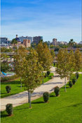
Today, the demand to inhabit the city is one of the most transforming trends of the 21st century, requiring the repositioning of the State to formulate and implement urban policies based on consensus and rationality, capable of providing cities with a project that responds to the dual requirement of combining the productive city, the green city and the inclusive city, economic development -with sustainability of non-renewable resources- and social cohesion, that is, employment, access to urbanization -land and/or housing, services and social facilities- and cultural integration. Figure 3
In short, unlike the foundational stage, as Argentina became an urban country, the city of La Plata -like the rest of the urbanizations- grew in a fragmented and turbulent way, on the green belt. During the 21st century, cities will continue to grow in the same conditions as they have done so far, especially in developing countries.3
1GTZ. Land tenure in areas of informal settlements in large cities of developing countries -Examples from Latin America and Africa- Faculty of Geography, Philipps-Universität Marburg Nov. 1998
The peripheries of the cities of the developed landscapes, especially in the United States, are built from a set of residential areas inhabited by middle-high income social sectors, connected by a road infrastructure where the use of automobiles is privileged. Meanwhile, in the suburbs of Latin American cities, in general, and in Argentina in particular, urban sprawl is characterized by poverty, informality and lack of infrastructure, equipment and basic services. In addition, during the last decades, new information and communication technologies have modified the spatial configuration with new modalities of urban expansion, which generate social polarization, residential segregation, fragmentation of the urban structure, etc. This results in a current periphery characterized by the addition of fragments, which generates social and spatial disintegration.
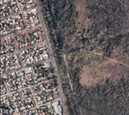
In the Partido de La Plata, especially in the last two decades, there has been a notable change in the morphology of the city that mainly affects the so-called peri-urban space, understood as the strip of territory between urban and rural areas.
Urban residential expansion towards the periphery translates into competition for land between different land uses and activities: increased occupation of new areas on the physical limits of the city and the retraction of intensive agricultural land -open-air and greenhouses- that are giving way to occupation related to residential use -permanent or weekend use-, recreational or leisure use, and industrial use, among others.
This situation means that the peri-urban area is highly heterogeneous, environmentally fragile, with imbalances and conflicts in the society-society and society-nature relationship, as large facilities and industries, garbage dumps, precarious settlements, dwellings, gated communities, etc. coexist in the same space in a complex manner, with patterns of behavior of the social actors involved - real estate agents, companies and inhabitants of the areas under transformation - who adopt their own strategies in accordance with their dominant logics and interests.
In the expansion process of the La Plata district, the transformation of agricultural land into urban land has shown a strong dynamic in recent decades. The reduction of rural land is particularly important if one considers that the district is the leading horticultural producer in Argentina, standing out nationally in the production of tomatoes, artichokes, celery, lettuce, strawberries and carnations. La Plata's green belt consists of a strip of land 6 to 12 km wide and more than 36,000 hectares in area, a third of which is productive - horticultural and floricultural activities, which extends between the city and the suburbs, on the one hand, and the rural area, on the other. According to Bozzano,9 of the total municipal territory of La Plata (94,200 ha), 15% corresponds to urban areas, 39% to periurban areas and 46% to rural areas. Figure 4
Thus, in the current landscape of the Platense green belt, the following uses can be identified as coexisting in the same territorial area:

Figure 6 Presentation of the 41st Argentine Congress of Horticulture.
(Peri-urban: discontinuous and fragmented mosaic landscape, with little value for the social collective).
In summary, urban dispersion that generates a discontinuous and fragmented mosaic landscape -with little social valuation-, is the main characteristic of the current peri-urban urbanization, with social tensions and land in dispute, as a result of the weakness of territorial public policies as opposed to the strength of the (real estate) market.
For many years it was assumed that the role of the State, through its urban public policies, favored diverse forms of social integration, the search for lowest common denominators within heterogeneity. If it is not the State, which sector of society is responsible for urban integration in the context of globalization? Could it be that current urban policies tend to consolidate a fragmented peri-urban area, with social tensions and disputed land?
In a first propositional approach, it is basic to reaffirm that the periurban area is a territorial space in constant transformation, which presents as a central problem the strategic value of its location. Therefore, it is essential to adequately characterize the land market:

Figure 7 Presentation of the 41st Argentine Congress of Horticulture.
(In order to modify the logic of a century of conformation of the peri-urban, there is a unique opportunity. “Society resignify the periphery as valuable green areas for urban áreas”)
In a second approach, it is important to explain three basic concepts for a new management:

Figure 8 Presentation of the 41st Argentine Congress of Horticulture.
(Territorial associated management, the way to transform the peri-urban into a green belt. articulation process)
The associated Territorial Management -GAT- to transform the current periurban area into a green belt, should be understood as:
In summary, it is necessary to move from the current normative-based urban public policies to those that promote associated management processes, in order to strengthen public policies and achieve territorial integrality in the peri-urban area.
Presentation of the 41st Argentine Congress of Horticulture.
Urbanization -productive capacity
■ With the same management model, the results will be the same as today.
■ A new management model, with three strategies:
▪ To go from the particular to the general.
▪ To go from the general to the particular.
▪ Mixed intervention
What is the real challenge?
Given the current situation, it is necessary to build a realistic project for the development and territorial (and landscape) planning of the peri-urban area, with a totalizing vision that is capable of synthesizing the multiple positions of all social actors and not only of those who have more power or capacity to impose their projects.
A new green belt concept, with the following objectives:
To the authorities of the 41st Argentine Horticultural Congress for the opportunity to present the paper that opened one of the workshops of the meeting.
To the Unit for Promotion, Research and Development - Landscape Engineering (UPID-IP). Faculty of Agricultural and Forestry Sciences. National University of La Plata. Avda 60 La Plata. La Plata, Argentina.
The author declares that he has no conflict of interest with respect to the publication of this article.

©2023 Opel. This is an open access article distributed under the terms of the, which permits unrestricted use, distribution, and build upon your work non-commercially.