eISSN: 2576-4500


Review Article Volume 6 Issue 4
1Seedling Growth Laboratory, Brazil
2University of Calcutta, India
3University Autonomous of Campeche, Mexico
Correspondence: Ricardo Gobato, Seedling Growth Laboratory, 86130-000, Parana, Brazil
Received: November 08, 2022 | Published: November 22, 2022
Citation: Gobato R, Mitra A, Valverde LF. Tornadoes analysis Concordia, Santa Catarina, Southern Brazil, 2022 season. Aeron Aero Open Access J. 2022;6(4):184-188. DOI: 10.15406/aaoaj.2022.06.00160
Large storms such as tornadoes and extra tropical cyclones have become increasingly common in southern Brazil. The season of strong storms has been increasingly evident between autumn and winter in southern Brazil, such as hurricane Catarina. Several tornadoes were evidenced in 2022 in this region, and the ones discussed here are from its and Concodia, which crossed the rural areas of Santa Catarina, causing great damage to their avian production. As the main focus, the one of Concordia was analyzed, classified as category F1, and approximate dimensions of 100m in diameter.
Keywords: tornadoes, storms, santa catarina, southern brazil, damage
A tornado is a violently rotating column of air that is in contact with both the surface of the earth and a cumulonimbus cloud or, in rare cases, the base of a cumulus cloud. They are often referred to as twisters or cyclones,1–3 although the word cyclone is used in meteorology, in a wider sense, to name any closed low pressure circulation. The occurrence of tornadoes has become increasingly common in the southern region of Brazil. Several tornadoes have formed and evidenced in 2022 in the states of Parana, Santa Catarina and Rio Grande do Sul, southern region of Brazil.4–8
Tornadoes come in many shapes and sizes, but they are typically in the form of a visible condensation funnel, whose narrow end touches the earth and is often encircled by a cloud of debris and dust. Most tornadoes have wind speeds less than 110 miles per hour (180 km/h), are about 250 feet (80 m) across, and travel a few miles (several kilometers) before dissipating. The most extreme tornadoes can attain wind speeds of more than 300 miles per hour (480 km/h), stretch more than two miles (3 km) across, and stay on the ground for dozens of miles (more than 100 km).9–12
Various types of tornadoes include the land spout, multiple vortex tornado, and waterspout. Waterspouts are characterized by a spiraling funnel-shaped wind current, connecting to a large cumulus or cumulonimbus cloud. They are generally classified as non-super cellular tornadoes that develop over bodies of water, but there is disagreement over whether to classify them as true tornadoes. These spiraling columns of air frequently develop in tropical areas close to the equator, and are less common at high latitudes.9–11 Other tornado-like phenomenon that exist in nature include the gustnado, dust devil, fire whirls, and steam devil; downbursts are frequently confused with tornadoes, though their action is dissimilar.12
Concordia
The Civil Defense of Santa Catarina confirmed on Tuesday morning (28) the passage of a tornado in Concordia, in the West, on Wednesday night (22). Wind gusts in the city reached 108km/h. According to the technical note of the agency, the tornado recorded in the municipality was of "low intensity and associated with a severe storm". At least 50 homes and rural properties were affected and the estimated damage so far has reached R$ 10 million. There were no injuries.13 Wednesday’s storm also wreaked havoc in other cities. There were records of landslides and flooding points in Chapecó, Cordilheira Alta and Campos Novos. In Aurora, in the Itajaí Valley, a flood blocked a section of the SC-350. According to the NSC Meteorological Center, a tornado is a weather phenomenon that occurs with the arrival of cold fronts when air moves quickly around a center of low pressure (Figures 1&2).13
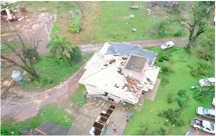
Figure 1 Photo of the damage caused in rural areas where the tornado passed, municipality of Concórdia Santa Catarina.14
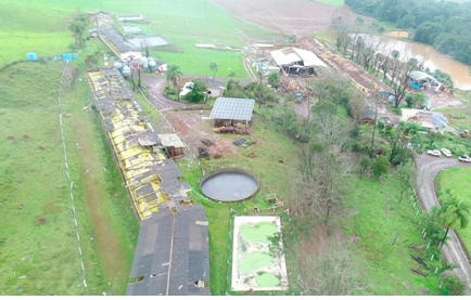
Figure 2 Photo of the damage caused in rural areas where the tornado passed, municipality of Concórdia, Santa Catarina.14
Itá
The Civil Defense of Santa Catarina confirmed the passage of a tornado in the city of It’a on the afternoon of Thursday, the 13th. The official report was published in the early afternoon of this Friday, the 14th. According to information already disclosed, the storm caused damage to public and private improvements, vegetation fall on buildings and public roads, in addition to electricity and communication cables being hit. A damage assessment is still being completed (Figure 3).14
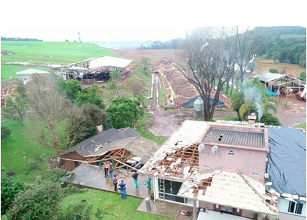
Figure 3 Photo of the damage caused in rural areas where the tornado passed, municipality of Concórdia, Santa Catarina.14
According to Civil Defense meteorologists, the phenomenon occurred between 4:20 pm and 4:40 pm and concluded that the instability super cell that passed through the municipality gave rise to a tornado, with an estimated speed of around 110-120 km/h (Figure 4).14,15
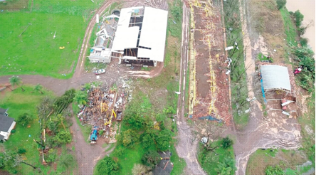
Figure 4 Photo of the damage caused in rural areas where the tornado passed, municipality of Concórdia, Santa Catarina.14
The last record of a tornado in the region was in June of that year, when part of the interior of Concodia suffered damage due to strong winds, which occurred in the region of BR 153 to the communities of Barra Bonita and Tiradentes (Figure 5).14,15
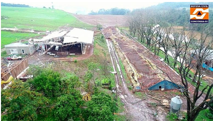
Figure 5 Photo of the damage caused in rural areas where the tornado passed, municipality of Concórdia, Santa Catarina.14
The Figure 6 shows the sea level pressure chart image, formulated by the Brazilian Navy, for June 21, 2022, 0012Z. It stands out for the analysis of the causes of the formation of the tornado, two zones of high pressure, one to the south of the Pacific Ocean, the other covering the whole of Paraguay, and the north of Argentina. And a low pressure zone south of the Atlantic Ocean. All causing a mass displacement of cold air.16
Figure 7 shows the sea level pressure chart image, formulated by the Brazilian Navy, for June 22, 2022, 00Z. It stands out for the analysis of the causes of the formation of the tornado, two zones of high pressure, one to the south of the Pacific Ocean, the other covering the whole of Paraguay, and the north of Argentina. And a low pressure zone south of the Atlantic Ocean. All causing a mass displacement of cold air.17
Large storms such as tornadoes and extra tropical cyclones have become increasingly common in southern Brazil. The season of strong storms has been increasingly evident between autumn and winter in southern Brazil18–26 such as hurricane Catarina.27
The Figures 6&7 shows the sea level pressure chart image, formulated by the Brazilian Navy, for June 21, 2022, 0012Z. It stands out for the analysis of the causes of the formation of the tornado, two zones of high pressure, one to the south of the Pacific Ocean, the other covering the whole of Paraguay, and the north of Argentina. And a low pressure zone south of the Atlantic Ocean. All causing a mass displacement of cold air.
The tornado observed by the Civil Defense of the State of Santa Catarina, was formed due to the shock of a large mass of hot air that were stationed over the Center-West, Southeast and Parana state regions, which blocked the advance of the cold front. Coming from Argentina, from which it was forced to move to the west of the southern region of Brazil, forming in the west and between the states of Rio Grande do Sul and Santa Catarina.
Analyzing the enhanced satellite images obtained from the REDEMET website Figure 8,28 for the cloud temperature of June 22, 2022, time (UTC) 00:00 to 11:40, it appears that the tornado has probably formed between 2 am and 4 am on the 22nd, with greater intensity at 03:20. According to the damage caused to rural properties in the municipality of Chapecó, Figures (1)-(5), it can be classified as category F129 with approximate dimensions of 100 m in diameter.
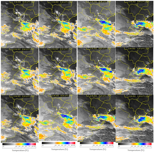
Figure 8 The figure shows 12 satellite images highlighted as a function of the temperature of clouds near the surface, for the time (UTC) from 00:20 to 11:40 on June 22, 2022.17 [Adapted by the authors].
A low pressure area of 1002 mb formed in the Pacific Ocean, west of the Chilean coast, between the 25th and 40th parallels, generated winds that gave rise to a cold front that moved into the southern region of Chile and Argentina, Figures 6&7. Pulled by a 1030 mb high pressure zone formed in southern Argentina, between parallels 40 and 45 South, added to the extra tropical cyclone of 986 mb of pressure in the South Atlantic, between parallels 55 and 60 South, created conditions for the formation of this strong cold front, which advanced through Argentina, Uruguay, Rio Grande do Sul, Santa Catarina. After the passage of this strong storm through these areas, it dispersed on the east coast of southern Brazil, entering the Atlantic Ocean, Figures 9–12.
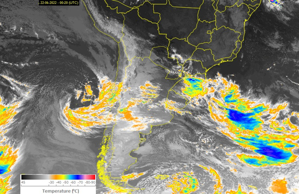
Figure 9 The figure shows satellite images highlighted as a function of the temperature of clouds near the surface, for the time from 00:20 (UTC) on June 22, 2022.17 [Adapted by the authors].
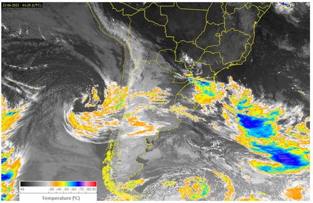
Figure 10 The figure shows satellite images highlighted as a function of the temperature of clouds near the surface, for the time from 01:20 (UTC) on June 22, 2022.17 [Adapted by the authors].
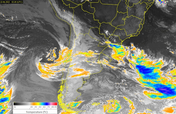
Figure 11 The figure shows satellite images highlighted as a function of the temperature of clouds near the surface, for the time from 02:20 (UTC) on June 22, 2022.17 [Adapted by the authors].
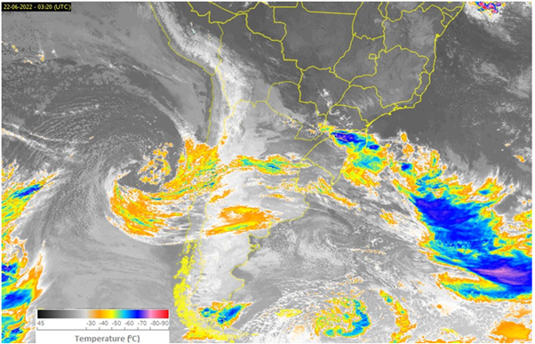
Figure 12 The figure shows satellite images highlighted as a function of the temperature of clouds near the surface, for the time from 03:20 (UTC) on June 22, 2022.17 [Adapted by the authors].
The Figure 8 shows 12 frames with enhanced satellite images of cloud temperature at 3000 feet altitude as a function of time (UTC) for June 22, 2022. The area covered is between latitudes 15°S and 40°S and longitude 45°W and 65°W. The analyzed images correspond to the southern region of Brazil, arranged in order of time from top to bottom, and from left to right, starting at 00:20, upper left corner and ending at 11:40, in the lower right corner. Thus corresponding to Figure 8 the images for the times: 00:20; 00:40; 01:20; 01:40; 02:20; 03:20; 03:40; 4:00 am; 10:20; 10:40; 11:20; and 11:40 (UTC) on June 22, 2022.
When analyzing the images at 03:20 (UTC) and 03:40, as the main highlight of greater interest, the temperature of the clouds in the region of the municipality of Concórdia, Santa Catarina, is found at -90°C, presenting a temperature gradient very high, in relation to nearby areas, thus indicating the possibility of occurrence of an intense vortex formed in this area. Figures 8–12 present enhanced satellite images of cloud temperature at 3000 feet altitude as a function of time (UTC) for June 22, 2022. The area covered is between the latitudes of 13 °S and 56°S and longitude 20°W and 105°W approximately. Thus Figures 9–12 the images for the times 00:20, 01:20, 02:20 and 03:20, respectively. From hour to hour, it aimed to analyze the displacement of the center of low pressure (1002 mb) on the Chilean coast, and the advance of the cold front area that moved across Chile, Argentina, in the West direction, changing direction to the collide with the high pressure area (1030 mb), causing a large amount of precipitation in the region of Patagonia Argentina, and moving towards the northwest of the southern region of Brazil.
The cold front that reaches the southern region of Brazil, mainly Santa Catarina and Rio Grande do Sul, causing heavy precipitation, Figures 8–12, gains more strength as it is pushed by the low pressure area in the Atlantic Ocean, moving rapidly around latitude 55-60°S and longitude 45-35°W.
Large storms such as tornadoes and extra tropical cyclones have become increasingly common in southern Brazil. The season of strong storms has been increasingly evident between autumn and winter in southern Brazil, such as hurricane Catarina. With a low pressure area of 1002 mb formed in the Pacific Ocean, west of the Chilean coast, between the 25th and 40th parallels, generated winds that gave rise to a cold front that moved into the southern region of Chile and Argentina. Pulled by a 1030 mb high pressure zone formed in southern Argentina, between parallels 40 and 45 South, added to the extra tropical cyclone of 986 mb of pressure in the South Atlantic, between parallels 55 and 60 South, created conditions for the formation of this strong cold front, which advanced through Argentina, Uruguay, Rio Grande do Sul, Santa Catarina. After the passage of this strong storm through these areas, it dispersed on the east coast of southern Brazil, entering the Atlantic Ocean.
Several tornadoes have formed and evidenced in 2022 in the states of Parana, Santa Catarina and Rio Grande do Sul, southern region of Brazil. The Concordia tornado, which crossed the rural area of Santa Catarina, caused great damage to its avian production. Classified here as category F1 and approximate dimensions of 100m in diameter.
None.
The Authors declares that there is no Conflict of interest.
None.

©2022 Gobato, et al. This is an open access article distributed under the terms of the, which permits unrestricted use, distribution, and build upon your work non-commercially.