eISSN: 2576-4543


Research Article Volume 7 Issue 1
1Ghana Civil Aviation Authority (GCAA), Ghana
2Ghana Meteorological Agency (GMet), Ghana
3Center for Climate Change and Sustainability Studies (C3SS), University of Ghana, Ghana
4Physics Department, Kwame Nkrumah University of Science and Technology, Ghana
Correspondence: Michael Padi, Physics Department, Kwame Nkrumah University of Science and Technology, Ghana
Received: February 16, 2023 | Published: March 23, 2023
Citation: Padi M. The oscillatory effect of chemical constituents, dynamics, barometric, and thermodynamics on weather over Accra, and Bissau. Phys Astron Int J. 2023;7(1):59-67. DOI: 10.15406/paij.2023.07.00285
A sharp contrast in atmospheric weather conditions prevailed over Accra and Bissau and that led to the oscillatory nature of weather conditions between the two cities. During the latter part of July 2022, Bissau experienced persistent and continuous rains whilst Accra remained fair and dry. It was realized that when an air parcel rises, low-pressure system is created at the surface but when the air parcel sinks, high pressure forms. Pressures were predominantly high over Accra and low over Bissau during that time. Models from CAMS were used to study chemical compositions to determine the concentration and effect of Sulphur Dioxide (SO2) over the two cities. Wind behavior over various levels in the atmosphere was considered using model products from ECMWF, satellite imagery from EUMETSAT, and t-phi gram from the Air Resources Laboratory of NOAA to study the thermodynamics of the skies. METAR, hourly observations made by the National Meteorological Offices from the two cities were retrieved from the AADS and Ogimet to study the barometric nature during the period. Results show that the atmosphere over Bissau had been less polluted as compared to that of Accra which makes Bissau to be persistently cloudy. Atmospheric chemical constituents would have to compete for moisture if the concentration is high and does not support the sustenance of massive clouds capable of producing rain. It has been realized that the development of anticyclone, an anticlockwise circulation at the 200 hPa level contributed to the cloud sustenance over Bissau during that time.
Keywords: Accra, Bissau, rain, weather, pressure, t-phi, Sulphur Dioxide (SO2), climate change
World bodies met to agree on every country to reduce the consumption of fossil fuels because it has caused “global warming”, an issue of “climate change”.1 Rainfall patterns have changed over places.2 Some places that were previously recording very high rainfall totals are now recording very low amounts because clouds are not allowed by human activities to thrive in such regions. Rains divert from their usual paths and benefit other new areas and result in change of usual weather conditions that occur at certain times. Of late, it is in December, towards the close of the year, when the northeast trade winds set in, that the coastal sector experiences substantial rains. The smoke, mostly composed of Sulphur Dioxide (SO2) from the oil fields in the Gulf of Guinea carries the smoke seaward and leave the required quantity that could sustain massive clouds to operate. During the major rainy season in Ghana (AMJ), surface winds become southerly, they carry the smoke towards the coastline and inland to prevent massive cloud formation where the compete for moisture. The previously very low clouds that Weather Observers issue alerts, do not exist frequently in Accra. Aircrafts that fly to and from Accra usually do not encounter bad weather conditions along the coast as they do in the recent past.
During the latter part of July 2022, frequent rains persisted over the coast of Bissau whilst Accra dwelled in a long dry spell. Even though it is the period of the “little dry season” where previously continuous drizzle becomes the order of the day, with people trying to hurriedly join buses at the roadsides to work, are not frequent in Accra again. Such heavy rains and violent storms that rip off the roofs of buildings do not manifest at the beginning of the year as they do in the past along the coast of Ghana. There were some postulations that the Summer of July 2022 would be the coldest summer ever!3 However, there had been reports of scorching sun over Europe, associated with wildfires and yet, worse conditions are still expected.
The write-up is made up of the introduction, study area, data acquisition, as well as the method of analysis where some situations that influence the weather like temperature, pressure, and atmospheric chemical contents were considered. Results and discussions were made in the latter part and conclusions were made with some references. The essence of this work is to point out atmospheric conditions that make weather over West Africa, and then to validate internet-based information that gets to the general public. It is also to make sure that flight operations are safe over the West African sub region through the reception of reliable weather information from the National Meteorological Services. This work opens the public to the internet, where reliable meteorological observations, including human and satellite observations as well as models that predict the future are kept. Studying this write-up would lead to the understanding of weather and then be able to make weather predictions. The script consists of an introduction, the study area, how data was acquired and the method of analysis, results and discussions, conclusions, and some references.
Study area
The study area of this research is over Accra and Bissau, in the West African sub region and part of the Atlantic Ocean, off the coast of Guinea-Bissau and the Gulf of Guinea. Bissau is located at latitude 11.9° N and longitude 15.5° W and Accra is at latitude 5.6° N and longitude 0.17° W. Accra is at an altitude of 69 m above mean sea level and Bissau is 39 m. Accra is the capital town of Ghana and Bissau is the capital of Guinea Bissau.
Data acquisition
Data for analysis were acquired on the internet from the sites, windy.com which combined numerous meteorological information from different forecast models and satellite imageries. Models from the ECMWF, GFS, ICON, and CAMS. CAMS is a site that is interested in Air Quality. Infrared and visible satellite imageries and RGB satellite imageries from EUMETSAT are also present at windy.com.4
Ground weather observations like surface temperature, and rainfall amounts for the two cities, Bissau and Accra were intercepted from the internet Aviation Digital Data System (ADDS).5,6 They transmit the weather information immediately after observations are made by the National Meteorological Services. The information is, however, readily available for scientists to analyze and advise decision-makers.
Synop and METAR from these two towns and others within the study area were acquired from the site, “Ogimet” and Aviation Digital Data System, ADDS on the internet. Synop and METAR are regularly transmitted at regular intervals for both public and aeronautical use. METAR is transmitted every one hour while the synop is at three-hour intervals. They describe the temperature and dew point temperature of a place as well as surface wind direction and speed, cloud amounts and height of cloud base, surface visibility, and the current weather conditions at the time of observation. The messages also provide the past weather, and what significant weather conditions took place. Atmospheric sounding by the Air Resources Laboratory, NOAA7-10 was used to analyze moisture contents of the atmosphere using the T-phi. Analysis of a place would proof whether it has the tendency to lift moisture or not and that leads to making weather forecasts.
Modeled wind charts were acquired from ECMWF from the windy.com web site on the internet where wind behaviors at the surface, 925 hPa, 850 hPa, 700 hPa, 500 hPa, and 200 hPa were considered. The winds helped in determining whether a particular airmass affecting the West African sub region is dry or contains moisture or dust and other gases that would influence weather and their source regions as well as their distributions. Global coverage of pressure analysis was conducted as well as local distributions over Ghana to identify how pressure systems dictate wind movements that can lead to weather forecasting. Troughs and ridges were identified from the charts, including how much moisture would be transported form the source regions to their respective sinks. Sulphur Dioxide charts were analyzed to show their distributions and the influences they have on cloud formation and rain. Various forms of satellite imageries, the Infrared was used to detect the temperature and height of clouds whilst the Dust RGBs was used to determine dust and other constituents of the atmosphere.
The study was initiated from an aircraft flying westward, cruising at an altitude of about 14,000 ft from Accra to Takoradi early in the morning around 7 am, local time. There was the hope that on the return of that trip, sky visibility would be better so that some sky pictures could be taken as has been usually done. Nonetheless, on the return, late in the afternoon sky visibility was still poor. Objects on the ground were not clearly visible as they do on Journeys from Accra towards the north. The atmosphere looked misty, and it persisted anytime travels were made to and from Accra to Takoradi. For this reason, denial of taking sky pictures, paved way to find out what was really reducing the visibility in the atmosphere.
Products from a reliable site, windy.com was implored, CAMS model revealed that SO2 was predominantly the gas that covers the coast like that. SO2 concentrations were monitored during the approach of storms in Ghana and realized that their tracks, movements, speeds, sustenance and distributions are influenced by this gas. Concentrations of other gases like NO2, CO, and PM2.5 were studied and realized that they do not have direct influence on cloud formation than SO2 along the coast of Ghana.
Thorough searches were made online to monitor and record daily values of the thermodynamic situations, considering how temperature and moisture changes in the atmosphere. Such a study gives an insight of how a parcel of air, whether moist or dry would be lifted at a particular location. Frequent studies of recent and current satellite imageries have been the hall mark of this study, and the analysis of SO2 content in the atmosphere. The study of wind direction and speed at different standard pressure levels and atmospheric pressure on the surface have been daily activity. Storm tracking, storm growth, movement and speed of storms, their decay, and sustenance have been calculated and predicted over various places around the West African sub region. Where storms form, why storms should form or should not form have been some of solutions to the hypotheses of this study. Geographical locations and surface conditions of places of interest were studied to know how they influence cloud formation and rainfall. Conditions over the open seas, such as pressures and wind speeds and directions were monitored to know where moisture will be coming from onto the West African sub region.
Adiabatic processes and thermodynamic situations
Adiabatic process is when an air parcel changes its temperature as it rises without allowing an inflow or outflow of heat to the parcel. For this reason, it is very important to find out if the atmosphere is dry or moist when making a weather forecast. Adiabatic processes are well studied when using the t-phi gram. On this chart, when the air at the surface is dry, the parcel is expected to be lifted with a certain rate of temperature reduction. When the air parcel is moist, its temperature reduction rate is lower, and therefore, remains warmer than when compared to a dry air. For this reason, the moist air always becomes warmer than the dry air wherever they exist together. The moist air then becomes less dense than the dry air that surrounds it and would therefore lift and leave the dry air below.
An air parcel that has a temperature lower than the air above cannot rise to greater heights to attain the cloud base for condensation to form where invisible water vapor will change its form to be visible as clouds. However, some of these favorable cloud formation conditions could be met but will not be able to form and sustain the clouds along the coast of Ghana because the atmospheric constituents that act as aerosols tend to compete for the moisture and the clouds thin.
If an air parcel assumes an upward motion, it creates a low-pressure system on the surface because of the lifting of mass. However, if on its upward journey and it becomes colder than the surrounding atmosphere, the air parcel sinks from that altitude and the surface low-pressure changes to become a high-pressure and the atmosphere clears. On a typical T-phi gram, the thick red lines on the chart indicate the environment temperature, the temperature of the height at which the parcel of air would be whilst the green line indicates the dew point temperature (Figure 1 & 2). The thin red slanting lines are the isotherms, therefore, when the temperature and the dew point lines are very close it indicates that the atmosphere is moist but when they are far apart, it indicates dryness. Therefore, a glance at the T-phi diagram over Accra indicates drier atmosphere at a certain level in the atmosphere (Figure 1). However, the atmosphere over Bissau is almost saturated with sufficient moisture because the lines are very close (Figure 2).
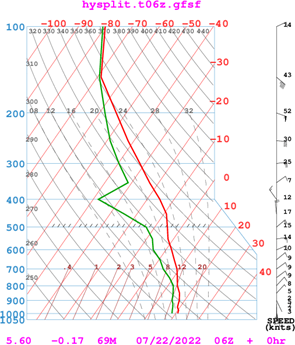
Figure 1 T-phi - Temperature, and Dew Point Temperature of the atmosphere on 22nd July 2022 over Accra.7
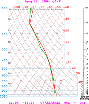
Figure 2 T-phi - Temperature, and Dew Point Temperature of the atmosphere on 22nd July 2022 over Bissau.8
Over Accra, the height of the 20°C isotherm was attained at 331 m (Figure 1) and 764 m over Bissau (Figure 2) on that day. This means that a much thicker atmosphere is warmer over Bissau than it is in Accra. Then, for adiabatic processes to be considered, a bigger volume of air could be lifted over Bissau to greater heights than it would be lifted over Accra. Mathematically, if a unit area over the surface is considered, about 764 m3 of air parcel would be lifted to form clouds over Bissau whilst only 331 m3 would be lifted over Accra, therefore, more clouds would be formed over Bissau than they would form in Accra.
Whereis the volume of air with temperature ≥ 20°C,is the unit length on the surface, andis the unit length of breath on the surface at various stations, andis the height of the layer of the atmosphere with temperature ≥ 20°C.
This means that if a threshold temperature of 20°C is set for air to be able to rise, an air parcel from the ground over Bissau would rise to an altitude of 764 m before it will stop rising. However, a parcel of air over Accra will only reach 332 m and would not rise again. The air parcel over Bissau will undergo much lower pressures as it rises and expand considerably for massive clouds to form than they would over Accra.
Thicker layer of warm moist air existed over Bissau, with much lower density that has the tendency to rise to greater heights. Such an atmosphere had accumulated a chunk of anergy that can be buoyant and can easily attain condensation, where moisture will be converted from the invisible to the visible state to produce massive clouds and rains. The atmosphere over Bissau is pictorially saturated through a considerable depth of the atmosphere to above 200 hPa, 12,400 m (Figure 2). Active storms stagnated off the coast of Bissau but those that affected the Sahel propagated at regular rates from east to west whilst the coastal sector of Ghana remained persistently clear (Figure 3).
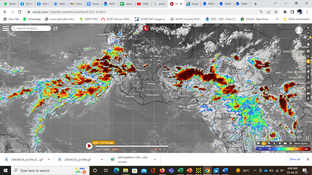
Figure 3 Infrared Satellite imagery on 22n July 2022 at 16:57 UTC indicating stagnant storms over Bissau and clear skies over Accra.4
Barographic situations
The standard atmospheric pressure at sea level is 1013 hPa11 so pressure values higher than this value could be termed as a high-pressure and any value lower than this could be termed as low-pressure. Low-pressure areas over the surface are associated with upliftment of moisture which will supports cloud formation whilst high-pressure areas are associated with subsidence which dissolves clouds. From the 0600 UTC observations made during that period, Bissau had pressures below the 1013 (Figure 5) and experienced rain on daily basis.12 Accra had pressure values higher than or equal to the standard pressure (Figure 4) and experienced fair-weather conditions with no rain for the period.13 Rainfall amount accumulations made at 0600 UTC for the past 24 hours over Bissau were 7.0 mm for 18th July 2022, 79.0 mm for 19th July 2022, and 24 mm for 20th July 2022.14 Satellite imageries confirmed that rainfall had affected Bissau almost on daily basis from 19th to 24th July 2022. However, no rainfall was reported over Accra for the same period, only misty conditions were reported consecutively at 0600 UTC with impaired surface visibilities.15
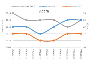
Figure 4 Atmospheric Pressure, air temperature, and Dew Point Temperature of Accra from 19th – 24th July 2022.5

Figure 5 Atmospheric Pressure, air temperature, and Dew Point Temperature of Bissau from 19th – 24th July 2022.6
Pressures over Accra were not well below the standard atmospheric pressure which would render the airmass less dense to be lifted to greater heights for massive clouds to form (Figure 4). Subsidence at that time was the order of the day. However, over Bissau pressures were well below the standard atmospheric pressure and the air had the tendency to rise to greater heights for condensation to take place and resulted in massive cloud developments (Figure 5).On the day Accra experienced a pressure of 1012 hPa, at 0600 UTC on 23rd July 23, 2022, it was associated with an increase in temperature and increase in dew point temperature which made the place drier. Even though the two stations had the same pressure of 1012 hPa and air temperature of 24°C on the 23rd July 2022, the dew point temperature was lower over Accra and higher over Bissau. This would mean that a little work would be done over Bissau to bring the air to saturation than it would be in Accra.
In Accra, the air temperature would have to be reduced from 24°C to 22°C before condensation could take place (Figure 4) but over Bissau, the air temperature would have to be brought from 24°C to 23°C to attain condensation (Figure 5). On the following day, 24th July 2022, pressure, temperature, and dew point temperatures remained the same and the atmosphere did not change, rain was the order of the day (Figure 9) over Bissau.
Dynamical situations
Cyclonic vortices (anticlockwise circulations) of winds extended from the surface (Figure 6) of the sea up to 700 hPa level, about 3,000 m into the atmosphere (Figure 7). Such wind circulations favor the atmospheric principle of lifting moisture to greater heights. However, over Accra, continental winds dominated the region, and northerly winds existed and persisted from the 850 hPa, about 1,500 m to about 300 hPa level, about 9,700 m (Figure 1) on the t-phi. Conversely, southerly winds extended from the surface over Bissau up to 300 hPa (Figure 2). During the research, cyclonic vortices were identified at the subsequent standard pressure levels at almost the same location over the Atlantic (lat 10oN, long 28oW) at the surface, 925 hPa, 850 hPa, and 700 hPa from the ECMWF forecast model on windy.com web site. Weather forecasting experience shows that when cyclonic vortices extend to greater heights of this nature, rainfall becomes abundant and frequent for a few days or weeks.16
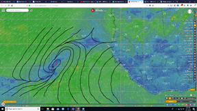
Figure 6 Analyzed surface winds on 20th July 2022 at 0000 UTC indicating a cyclonic vortex over the mid-Atlantic Ocean.
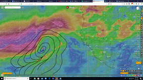
Figure 7 Analyzed 700 hPa level winds on 20th July 2022 at 0000 UTC indicating a cyclonic vortex over the mid-Atlantic Ocean.
Chemical situations
Production of resources and oil exploitations along the Gulf of Guinea has influenced the atmosphere and changed rainfall patterns along the coast of Ghana over the past few decades.17 SO2, Sulphur Dioxide gas which has been trapped along the coast of Ghana, as evidenced from the CAMS model, and has greatly affected cloud formation. It has become very difficult for clouds that leads to substantial rainfall and its sustenance to form along the coast. Research indicated that on days in Accra when SO2 is a minimum, coincides with substantial amounts of rainfall, especially if there is an approach of a rainstorm along the coast of Ghana. However, there are days when SO2 values can be low but if certain dynamic conditions are not favorable, rain cannot form along the coast of Ghana. During the early part of the year 2022, at the beginning of the rainy season over southern Ghana, active approaching storms towards Accra, from the east were seen on satellite to have dissipated as they encountered high quantities of SO2 along the coast of Ghana. Other situations on storm approach where SO2 is reduced have manifested appreciable amounts of rains recorded in Accra.
The study of forecast models paved way to anticipate the source of SO2 gas along the west coast of Ghana (Figure 8). Takoradi is a town quit close to the source of the emission as indicated on the CAMS model from windy.com18 and reports higher amounts almost on daily basis. The model reports appreciably low SO2 concentrations over Bissau compared to that of Accra with the peak over Takoradi. On 23rd July 2022, the estimated quantity over Accra was 1.92 mg/m2 and 0.25 mg/m2, however, 18.44 mg/m2 was anticipated for Takoradi (Figure 8). The distribution of this gas along the coast of Ghana had been seen to depend on wind direction and speed at the lower levels of the atmosphere. The concentration reduces over Accra when lower-level winds, and winds below the atmospheric boundary layer assumes a more easterly component than the usual westerly component along the coast of Ghana. However, the west coast of Ghana remains highly concentrated almost always.
Results have shown that high concentrations of SO2 could dissipate clouds and approaching storms. A cyclonic circulation developed over the coast of Guinea Bissau, from the surface to about 3,000 m into the sky sustained continuous and persistence rainfall over Bissau. The circulation permitted sufficient moisture can be carried aloft to greater heights and form clouds that produced substantial amounts of rainfall. Fossil fuel exploitation has influenced rain formation over the Gulf of Guinea and has reduced cloud formation along the coast of Ghana. Takoradi and Axim, towns along the coast of Ghana that records the highest rainfall now hardly receives any rains and changed the rainfall pattern. Forecast making for the coast of Ghana had now become tactful where SO2 concentration would have to be included. Wind direction at different layers of the atmosphere is to be examined when making weather forecasts over West Africa in addition to atmospheric constituents. The cyclonic vortices that developed over the coast of Bissau made the place to attract and raises sufficient moisture into the atmosphere to sustenance massive cloud developments.
Weather presentation
Presenting weather on TV in Ghana had turned to issues where people who are not Meteorologists have to present weather whilst Meteorologists sit down and watch.19 No proper description of the atmosphere has been made laypersons to understand exactly what will really happen in the presentation. Approaching storms which previously graze the coastline to produce rain for Accra and then continue to the west of Ghana, to Cape Coast and then affect Takoradi and Axim as the storm propagates, are now conditions of the past. Storms that affect Takoradi now take northward tracks, slightly north of the coastline and annual rainfalls have decreased over Takoradi and Axim since fossil fuels started providing money for Ghana.20
People who do not understand the meteorological terms take their expressions to be jargons, however, the public understand satellite imageries very well. Weather issues needs to be framed for people to take them seriously and act accordingly.21 Laypersons should be made to know that rainstorms cannot survive or be sustained in a smoke infested atmosphere so that they can help in changing human behaviors that will lead to excessive emissions in local communities. Rainstorms will not thrive in excessive aerosols, like smoke and dust because the aerosols will have to compete for moisture which the storm cannot provide.
Analysis indicates that there had been no change in surface dew point temperature and air temperature, as well as atmospheric pressure on 23rd and 24th July 2022 at 0600 UTC over Bissau (Figure 5) so it is expected that the same weather conditions are expected to prevail. Frequent occasional rains still exist over Bissau (Figure 9). Temperature remained at 24°C, dew point temperature of 23°C, and 1012 hPa surface pressure at 0600 UTC (Figure 5). However, Accra remained virtually cloudless with an increased surface pressure from 1012 hPa to 1013 hPa, air temperature of 24°C with dew point temperature of 22°C (Figure 4,10,11).
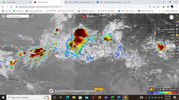
Figure 9 IR satellite imagery on 24th July 2022at 0804 UTC, indicating active storms still stagnating over the coast of Bissau for many days and fair weather persistently over Accra.4
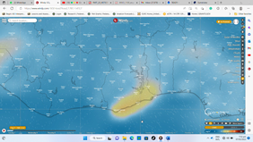
Figure 10 Model chart from CAMS for 7th February 2023 showing a chank of Sulphur Dioxide along the coast of Ghana.

Figure 11 IR Satellite imagery from EUMETSAT on 7th February 2023 indicating active storms over southern Ghana but without affecting the coastal strip.
An ideal case of rain over coastal Ghana
On 7th February 2023, conditions seemed favorable for the east coast of Ghana, especially Accra, to experience rain but did not materialize. Winds at the surface were southwesterlies (Figure 12) indicating a sufficient supply of moisture from the Gulf of Guinea. However, at the 925 hPa southwesterly winds still prevailed (Figure 13), an indication that moisture depth reached 750 m from the surface. At the 850 hPa, winds were southeasterly over the southeast coast of Ghana (Figure 14), an ideal case that Accra should get some rain. On 3rd June 2015, a similar situation at the 850 hPa occurred along the east coast of Ghana and Accra got flooded.22 Now, right from the 700 hPa through the 500 hPa, and to the 200 hPa, winds have consecutive easterly components to indicate that storms could form to the east of Ghana and be propelled to the west.23 Wind directions in the northeasterly at the 700 hPa (Figure 15), southeasterly at the 500 hPa (Figure 16), and southeasterly at the 200 hPa (Figure 17) usually make storms to develop over southern Ghana and propagate towards the west. At this time, the upper westerly winds at the 200 hPa which usually affect Ghana during the dry season from December to February just changed to become easterlies (Figure 17).

Figure 12 Surface Model chart from ECMWF on 7th February 2023 at 0600 UTC showing southwesterly winds along the coast of Ghana supplying moisture further inland of the country.

Figure 13 925 hPa Model chart from ECMWF on 7th February 2023 at 0600 UTC showing southwesterly winds along the coast of Ghana supplying moisture further inland of the country.
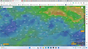
Figure 14 850 hPa Model chart from ECMWF on 7th February 2023 at 0600 UTC showing southeasterly winds along the east coast of Ghana and converging with northeasterlies over the southeast of Ghana.
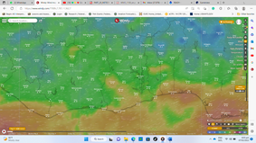
Figure 15 700 hPa Model chart from ECMWF on 7th February 2023 at 0600 UTC showing northeasterly winds along the east coast of Ghana, making sure that storms that will form over the east of the country will be propagated towards the west.
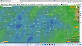
Figure 16 500 hPa Model chart from ECMWF on 7th February 2023 at 0600 UTC showing southeasterly winds along the coast of Ghana, an indication of sufficient moisture depth for the West African sub region.

Figure 17 200 hPa Model chart from ECMWF on 7th February 2023 at 0600 UTC showing southeasterly winds along the east coast of Ghana, initiating a ridge, a clockwise wind circulation over southern Ghana.
Earlier satellite imageries on that day, 7th February 2023 showed massive clouds to the eastern portions on the Gulf of Guinea which could have produced rain for the east coast later in the day could not be sustained due to the high concentration of Sulphur Dioxide (SO2) along the coat of Ghana (Figure 10). The approaching storms dissipated as they encountered excessive SO2 along the coast of Ghana and rather rejuvenated over areas north of the coastline and produced violent storms (Figure 11) that ripped off roofs of buildings, broke branches of trees and uprooted big trees on that day.
Pressure distribution across the globe on that day, 7th February 2023 indicates that moisture supply to Ghana was mainly from the North Atlantic Ocean rather than the usual source from the South Atlantic Ocean. The Azores high-pressure system seem to be very active, reaching 1040 hPa while the St. Helena high-pressure reached only 1020 hPa, with a low-pressure that developed over Ghana (Figure 18). These allowed more moisture from the North Atlantic Ocean to flow into the low-pressure system developed over Ghana than it would flow from the South Atlantic Ocean. Due to these situations, the inland areas of Ghana became favorable to sustain massive cloud developments than it would be along the coast of Ghana if more of the moisture were to come from the south Atlantic Ocean. Over the West African sub region, on the surface pressure chart, there had been an extension of the Equatorial Trough (the low-pressure over Ghana) into North Africa, a situation that allows more moisture into the sub region from the Atlantic Oceans.
On the surface pressure chart, a pressure isobar of 1010 hPa engulfs Ghana with a ridge extending towards the mid-western portions of the country from the North Atlantic Ocean bringing in so much moisture (Figure 19). However, another ridge extends from northern Africa to the eastern borders of Ghana, supplying condensation nuclei to mix up with the moisture to sustain cloud developments over the middle portions of Ghana. The magenta color on the Dust RGB satellite imagery indicates dust raised from the ground (Figure 20). The main dust source region is in Chad with a track towards northern Nigeria, eastern Niger, and northern Cameroon. These areas, however, corresponds to the ridging of the high-pressure system over North Africa indicated on the pressure chart (Figure 18). The blue color stretching across the whole of Ghana, extending westward into the Atlantic Ocean corresponds to the ridging from the high-pressure system from the open waters of the North Atlantic Ocean.
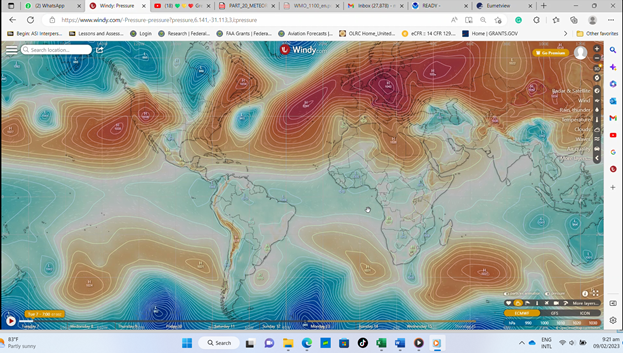
Figure 18 Surface Pressure chart from ECMWF on 7th February 2023 at 0700 UTC indicating very active high-pressure system over the North Atlantic Ocean (the Azores) and a weak high-pressure system over the South Atlantic Ocean (the St. Helena).
Massive cloud developments that lead to the sustenance of substantial rainfall existed over Bissau than they do over Accra. It can, therefore, be concluded that when an air parcel rises over a place, low-pressure system forms at the surface as it did over Bissau but when the air parcel sinks, high pressure is formed just as it happened in Accra during the study period. According to frequent satellite imagery observations it can be realized that rainfall is in surplus at Bissau and deficit in Accra. Atmospheric pollution had been comparably low over the coast of Guinea-Bissau and could be contributing to rainfall surplus whilst the highly polluted atmosphere over Accra could be a contribution factor to the rainfall deficit.
A moist atmosphere with a lower pressure and higher dew point temperature supports massive cloud formation that leads to substantial rainfall amounts whilst a moist atmosphere with a higher pressure and a lower dew point temperature leads to fair weather conditions. A high SO2 polluted atmosphere turns to dissipate approaching rainstorms and inhibit massive cloud formation. The cyclonic vortex that was created over west coast of Bissau has induced moist southerly winds into Guinea Bissau where they carry and deposit great quantities of moisture from the sea. Accra had no problem with moisture availability but the atmosphere in not conducive for the sustenance of massive cloud developments.None.
None.

©2023 Padi. This is an open access article distributed under the terms of the, which permits unrestricted use, distribution, and build upon your work non-commercially.