Journal of
eISSN: 2573-2897


Review Article Volume 4 Issue 6
Faculty, Architecture and Urbanism College, Mackenzie Presbyterian University, Brazil
Correspondence: Carlos Guilherme Mota, Faculty, Architecture and Urbanism College, Mackenzie Presbyterian University, Brazil
Received: August 24, 2019 | Published: November 28, 2019
Citation: Mota CG, Sumner AM. Urban waters in São Paulo. J His Arch & Anthropol Sci. 2019;4(6):222-228. DOI: 10.15406/jhaas.2019.04.00205
The reflection and projects exposed here can be seen as a catalyst, restricted to our perceptions and traits in order to better understand the city. These are projects for São Paulo’s urban waters that should be developed with an interdisciplinary approach. And assume for Architecture, the understanding of its time and nature that vary so much.
Keywords: culture, landscape, channels, lagoons, São Paulo
Information, as a powerful tool and substrate of the contemporary situation, contains, however, a sort of contrary correlation that is the constant remission meaning: an imagetic world of the cascading reference where everything refers to something else, so that nothing actually is and everything is equivalent. And if the work combines without reflecting, it merely associates by any code. Therefore, it is difficult to conceive the architectural object as in such variability it can be any, which doesn’t mean that it doesn’t occur. The city seen at its best is founded in a relation between civilization and culture, where the first performs and implements the invention and hypothesis of the other (Hannah Arendt). However, what we see is that the instrumental reasoning, civilizing in principle, tends to however contain its own sense in itself-and therefore acting independently of culture, becomes meaningless. The monumental gap between infrastructure network and urban grid in many Brazilian cities and metropolis provides the amount of reduction of our social contract as a civil society. Examples of such a gap associated with urban leniency,1 are the “Minhocão” viaduct tearing the downtown areas, the floods we all have to put up with every summer, the tin schools, the terminals in public squares such as Bandeira D Pedro II and Princesa Isabel: why should we park in central areas and public squares-double contradiction, what by nature circulates, the bus? by leniency and/or inertia of traffic engineering? That was purely an instrumental practice worldwide and that perpetuates itself among us? This is a question that may be investigated further by colleagues in Philosophy, History and Social Sciences.
The metropolis is the exacerbated manifestation of today’s cities with all the distortions related to this scale exacerbation. It is also the most complex among contemporary urban conditions and certainly the most instigating in terms of knowledge production. To think of the relationship between architecture and cities is to provide its infrastructure functionality but also to perceive it capturing its grids, traces and geography. In the projects listed below, the lagoons revived in the sand ports along with the landscape designed retention channel along the rails; the bypass channel parallel to the Tietê river, the public pools upstream in the Guaraú stream flowing into the Cabuçú de Baixo are part of the restlessness to draw the geography, and infrastructure from an optical point of view: a visual, tactile and physical perception of the city’s opacity (or transparency) and situation (or undefined location). In a certain way outlining a partie that involves the drive to establish perceptive reference situations (in the broad sense as seen by Merleau-Ponty), even in the case of infrastructure, in order to create differences in a saturated city, without wanting to mark fixed attention points, the "monument" or isolated building, but to make the grids on the various scales and hidden traces and topography visible, allowing de-congestion: the come and go of people and information, unblocking and clearing both our vision as well as water and mobility systems.2
Such an attitude obviously presupposes the articulation between ethics, technique and aesthetics in architecture and civil society’s exercise alike: allowing architecture to be done at its best. If the scale and extent of a city’s infrastructure provide a measure (or limit) of that society’s social contract, the broader and more accessible the infrastructure of a city, the more complete that city will be and in its broadest sense, The Active Life in the words of Hannah Arendt. But the vision of each construction work is part of its intrinsic hypothesis. To perceive the city is to perceive where we are. Upwards, low lands, valleys, plains, north, south, river, between rivers, hills, sparse, dense, periphery and center. Architecture is always structured by a given situation, even abstracting the surroundings.1,2
Making the landscape
Three projects
Arco Tietê: Candido Malta Campos Consortium-USP Hydraulics Technology Foundation+Invited Architect4
The scope of the public call for the Arco Tietê is the area to the north of Tietê River from Tatuapé to where it meets the Pinheiros River. Having participated as invited architect specifically focused on Urban Waters projects, involving new morphologies, the first approach were based on the survey of the upper limit of the Tietê River (maximum flooded area) produced using air photogrammetry in 1930 by Sara Brasil Company (Figure 1).
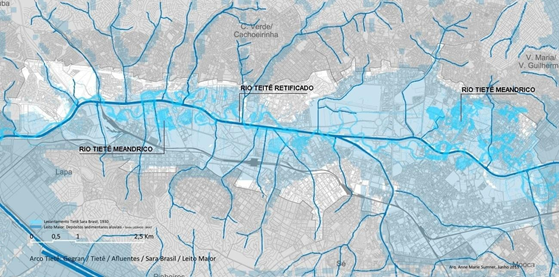
Figure 1 Tietê river maximum floodplain area in blue (referred to as greater river bed or leito maior) and its tributaries superimposed on São Paulo city’s registered mapping in white and gray. Arco Tietê call, 2013: Gegran/Tietê/Tributaries/ Sara Brasil/Greater River Bed.
Sara's map of the greater river bed superimposed on the current registered and urban situation after straightening the Tietê river, together show the river’s original-and perennial-runoff and drainage area. Even with another spatial setup, these areas are the Tietê’s largest river bed-the maximum area of its floodplain-and are therefore a fact. The opposite of this is São Paulo citizen’s current situation being flooded every summer. In the Great Flood of 1929, the State Art Gallery was part of the greater river bed, which is the maximum level that the water reaches approximately every 100 years. The river will always try to reach its original area again no matter how. The idea is to re- draw it, see and perceive it. The basis for the Bypass Channel, Deltas and local channels proposal (Figures 2,3&4) characterizes a new morphology that articulates the floodplain with the Serra da Cantareira foothills, involving the infrastructure of the water flows and urban landscape.
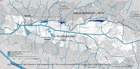
Figure 2 Conceptual Projects with Bypass Channel/Deltas/Local Channels/Channel and Railroad Lakes. Superimposed on SP Arco Tietê registered map: Gegran/Tietê/Tributaries/Topographic Line at approx. 730.00/ Bypass Channel.
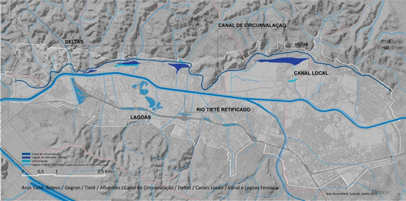
Figure 3 Perspective of the Conceptual Project terrain with Bypass Channel/Deltas/Local Channels/Channel and Railroad Lakes.
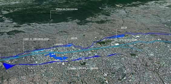
Figure 4 Perspective of the Conceptual Project area with Bypass Channel/ Deltas/ Local Channels/ Channel and Railroad Lakes.
Bypass channel
In the initial proposal, the bypass channel is broad and open at 730m above the sea level, that extends from the meandering Tietê river, bordering the entry to São Paulo via Ayrton Senna highway until it meets the Pinheiros river to the west. This is a conceptual guideline, articulating urban design and infrastructure aimed at making a city at its best. At the pedestrian scale a bordering river park is structured all the way to the Cantareira foothills. The idea is to capture the waters of the Tietê affluents before the river’s mouth thereby reducing its volume. The Cabuçú de Baixo, Mandaqui and Carandirú streams, among all others, are retained in the bypass channel and slowly drained after the rains before reaching the Tietê. Naturally, technical procedures such as mobile dams, sand boxes and filtering must be dimensioned as necessary, considering the outflows, diffused and sediment loads. Moreover, the following proposals-local deltas and transversal channels-also retain so that the waters reach the rivers slowly and clean.
The artificial deltas
Located between the bypass channel and the Tietê appear as large lagoons, uniting rivers and streams strongly re-drawing the landscape and extending the water retention areas in this region. They are located in strategic areas: considering the water flow, by constantly articulating where the rivers and streams meet and the urban perspective because they confer per se an enjoyable and urban friendly quality in design to the frailed surroundings. These deltas are auxiliary to the bypass channel and can be implemented together or separately without conflict.4
The local channels
Appear in smaller proportions downstream of the deltas, i.e., they are interventions closer to the Tietê river. They are transversal channels to the tributaries, with reduced proportions implemented bordering a few streets along the pedestrians paths. They also serve as filtering channels of manageable size that don’t require any expropriation and can therefore be introduced in greater number and pulverized. Some of the main tributaries of the Tietê were included in the project, an initial search of these water beds where small pilot channels can be implemented: the first crossing the Carandirú stream along the Zachi Nachi Avenue
(Figure 5), the second crossing the Mandaqui stream along Madalena de Madureira Street and a third crossing and interconnecting the Água de Pedra and Cabuçú de Baixo streams extending from Balsa Street to Nossa Senhora do Ó Avenue.
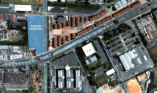
Figure 5 Arco Tietê: Carandirú: Local Channel (double) Av. Zaki Narchi with Retention Reservoir/Green Area subject to flooding.
SP east-west connection-prestes maia 2006 award: a scar marks the city: solutions for the elevated highway5
Launched in 2006 by Governor José Serra seeking solutions to the urban scar/minhocão in SP, in the project for the Prestes Maia Award we proposed dismantling of the minhocão. The question that remained was what to do with the city’s east-west connection traffic flow. The project’s idea involves historical and geographic aspects associated with a solution for the east-west traffic flow consequent to dismantling the elevated highway. Our proposal was to use the old Sorocabana/Central do Brasil/Santos-Jundiaí railway that used the same path approximately 100m wide, which was used for transporting cargo. This path also includes the proposed bordering channel with a system of lakes in the Água Branca area and now obsolete Rudge and Lapa patios of the railway (Figure 6). The underutilized railway also incorporated intensified use of passenger trains– as well as a bus and car transportation system on both sides of the rail. Cargo would be transferred to the railway ring (Figure 7).
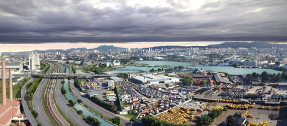
Figure 6 Aerial perspective: East-West connection: image of the Antárctica viaduct: passenger trains/autos and bus road system/ drainage and scenic channel/ lakes.

Figure 7 SP registry survey with the East-West Connection from Bresser to Lapa: Rails/Channel/Lakes. Below: Cuts: Rails/Channel/Lakes.
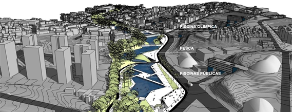
Figure 8 Renova São Paulo Public Tender: Guaraú stream and Public Swimming Pools System that flow into the Cabuçú de Baixo stream and consequently into the Tietê river. 2010.
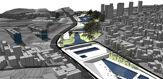
Figure 9 Renova São Paulo Public Tender: Guaraú stream and Public Swimming Pools System that flow into the Cabuçú de Baixo stream and consequently into the Tietê river. 2010.
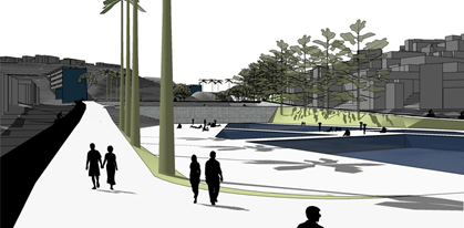
Figure 10 Renova São Paulo Public Tender: Guaraú stream and Public Swimming Pools System that flow into the Cabuçú de Baixo stream and consequently into the Tietê river. 2010.
The channel and the lakes
The channel and the lakes are articulated with open air streams whenever possible. The setup would act as a reserve-drainage of the waters that come from the high lands in the city, in addition to humidifying the air. The idea is that this channel would slowdown the water flow by detours to the lakes and finally draining them into the Tietê. The resulting peninsula starts at the mouth of the Tamanduateí river, extending until Lapa and is bordered by the Tietê river. This peninsula could become an area of urban excellence not only due to the diversity of uses and large infrastructure provided, but also thanks to the new landscape created by the waters.6
The surroundings
Considering that the project intends to optimize the railway infrastructure, roads and water capacity, irradiating in its surroundings, we expect that successive urban operations will be necessary in the immediate area of influence of the project. This initiative entails the need to revise the urbanistic laws to meet the propositions of new usage coefficients, while ensuring rigid control of the occupation and appropriate regulations regarding soil permeability, considering it is a territory of floodplains. New uses should occur with the updated legislation: in areas where industries have been deactivated by merging the various uses (residential, services, commerce and institutional uses) as well as in regions around the stations that tend to get denser.
Project for the guaraú/cabucú de baixo streams- renova sp contest, 20107
Considering that the urban waters solution involves the entire system of river basins and sub-basins, this project also refers to important water treatments and retention upstream, for the headland regions, along with integrated planning (flood control), i.e., linear parks, housing and transport in each municipality. Our proposal involves retentions articulated in systems of dams adjacent to Sabesp’s largest water treatment station. Its location is at the boundary between the non aedificandi area of the Serra da Cantareira and the beginning of the urbanized area of the metropolis with high declivity and strong erosion.
Considering this declivity, we proposed a water park with bicycle route designed together with a sequence of 5 dams. In this system we proposed creating a set of reservoirs, pools and lakes to help the Tietê river flow upstream as well as providing large leisure areas. As a result, both urban sides of the stream are connected to the adjacent Cantareira and Horto Florestal parks. The question that arises in these scales and especially in São Paulo is how the city structures itself considering this vast area with profusion of water and irregular topography covering 1.500 km2, unlike the flat plains of Paris with 105km2 and Manhattan with 127 km2. Namely ~80km of subway in SP vis a vis ~200km in Paris and ~400km in NY. The infrastructure considering the urban occupation, again gives us a measure and amplitude of the social contract corresponding to each society. From the point of view of the city’s design and its habitability and fruition, if the geography represents a vector in large scales, in the case of the areas in question, given its great extension and congestion, they seemed invisible. After all, reaffirming the issue, while the instrumental reasoning, civilizing in principle, brigs on its sense of being-and therefore operates independently of culture–it becomes meaningless. This seems to be what has happened among us. Correlated to the idea of Hannah Arendt’s Active Life and civil society at its best, therefore, the idea of the architecture’s influence and action would be to make the city visible and tactile, through and with an ethical, technical and aesthetic understanding in all its scales.
Contribution to flood control-Scope
The water bodies created, channel and lakes, are devices that allow the tributaries within our scope have their maximum discharges in the Tietê River within the limits set by the project implemented in this river. These limits are the so-called "discharge flow restriction" in this river, established by the "Plan for Macro-drainage of the Alto Tietê Watershed", without which the municipality of São Paulo city will remain subject to the consequence of floods.3,4
Constructive guidelines of the channel (and lakes)
Clearly, at this stage, one can only conceptualize some of the main devices that the system should have. In due course the complex relations of channel with all urban utilities shall be solved in the project. In particular, the intersections with the transversal lanes (such as the crossroads with projections of Pacaembu Avenue, extension of Pompeia Avenue and Antarctica flyover, for example) with their present channels (of tributaries, etc.) shall be harmonized. As regards water inflows into the channel, there will be multiple situations, whereas the water outflows of the channel, there will be several of these close to the number of tributaries covered. In other words, the rain-river paths that exist today between the railroad and the Tietê river shall probably be maintained in number, naturally disciplining (improving) these ducts, which will be opened as much as possible. Situations may occur where the channel itself, in limited terms may have to be covered. The channel (added to the lakes) shall have a permanent function, with circulation of waters, hopefully only from surface rainwater and underground water (i.e., the springs). The channel (and lagoons) shall also help to control floods. The first will be made possible at the deepest part of the channel (and lagoons) with outputs dimensioned so that the outflow matches the outflow. The second will be made possible from the upper port of the channel (and lagoons) with much larger outputs than the lower outputs, so that they flow downstream (as necessary to the Tietê River), in a determined period of time, so as not to exceed the flow that each tributary can take, i.e., so that the "volume" can be drained without problems (Eng. Renato Zuccolo).7
1Sumner, Anne Marie. Leniência Urbana in Móbile Magazine, CAU-SP, N. 3, 2016, São Paulo, SP,
Brazil.
2The term optic seizure was used in my PhD thesis and proposed in communication with Otília Beatriz Fiori Arantes. The term appears in the Preamble, referring to the projects presented in the thesis and is also part of the lineage of the authors of pure visibility, who observe the differences between optical and tactile nature of art.4
3In a world of constant imagery, to seize the landscape or surroundings became difficult: how to stop the eye that never stops moving? At the II International Architecture Biennale in São Paulo in 1992, I presented the project Opacity and Situation that contemplates the restlessness concerning this invisibility in todays cities. The project published in the Revista Oculum N.4 has the following text written by me: “There is no opposition to the landscape whether built or natural. Neither a desire to integrate to it. Nor simply highlighting the landscape. It is a common field where one presupposes the other. Desert, wall, screens and blades fix the eye that never stops seeing"
4Author: Anne Marie Sumner, Collaborating Architects Andrea Conard, Juliana Pellegrini, Uriel Bianchini Cardoso. The Engineers connected to the FCTH-USP are: Luiz Orsini, Orlando Natale, Ana Paula Brites
5Authors: Architects Anne Marie Sumner (coordination) Flávio Marcondes, Hector Vigliecca, Titus Livius Frascino, Vera Santana Luz, Consulting Engineer Renato Zuccolo-Waters; Engineer Cláudio Macedo/Sistran-transport; Surveyor Irineu Idoeta-zoning/areal photogrammetry.
6Technical Report by Eng. Renato Zuccolo for the Descriptive Memorial.
7Author: Architect Anne Marie Sumner. Collaborators: Architects Jorge Felix, Renato Sordi. Consultant: Engineer Francisco José Toledo Pisa.
None.
Authors declare that there is no conflict of interest.

©2019 Mota, et al. This is an open access article distributed under the terms of the, which permits unrestricted use, distribution, and build upon your work non-commercially.