Journal of
eISSN: 2573-2897


Review Article Volume 7 Issue 1
1Department of History, Bethune-Cookman University (retired), USA
2Department of Anthropology, University of Florida, USA
Correspondence: Fletcher Crowe, Department of History, Bethune-Cookman University (retired), USA
Received: January 21, 2022 | Published: March 4, 2022
Citation: Spring A, Crowe F. Historical Archaeology of Fort Caroline: New Perspectives. J His Arch & Anthropol Sci. 2022;7(1):9-18 DOI: 10.15406/jhaas.2022.07.00249
This multi-disciplinary archaeological research proposes a new location for Fort Caroline, the first fortified settlement in North America built in 1564. Thought to be located on the St. Johns River six miles from its mouth and near the Fort Caroline National Memorial, all archaeological investigations have failed to locate it there, or elsewhere in Florida or in the Southeast. This analysis is site-specific based on new data by the Fort Caroline Archaeology Project (FCAP) using original sources and on-site archaeology. It locates Fort Caroline on the St. Marys River. First examined are thirty-one criteria described in original 16th French and Spanish documents and compared with 19th and 20th century English translations. Second, an analysis of 16th and 17th century maps by French, Spanish, and British explorers provide support for the fort’s location on the St. Marys River, and that the Spanish marched to Fort Caroline from St. Johns River’s north shore (not St. Augustine) in September 1565. Third, FCAP’s archaeological investigations located features of Fort Caroline, including the large bluff and freshwater spring in the area, tidal creek, and specific river-characteristics (exact depth, currents) consistent with features reported by the French in 1564. Fourth, findings of Native Americans artifacts and some date-appropriate artifacts are discussed. Finally, the research supports that St. Augustine was founded in 1565 by Menendez who built several forts there after the demise of the French in Fort Caroline (1565) and after the Spanish abandoned the fort in 1568.
Keywords: Fort Caroline, Southeast Colonial History, French and Spanish Florida, Early Florida Maps
The question of where Ft. Caroline was located is an important and controversial issue in Florida history. The City of St. Augustine, located in northeast Florida, about 35 miles (56km) south of Jacksonville, is considered the oldest continuously inhabited city in North America. Its history is based on Pedro Menendez, the Spanish general whose troops attacked and destroyed Fort Caroline, and subsequently built forts and settlements. If the French colonists had established a permanent settlement, it is possible that Florida might have become a French colony. The Spanish eradicated the French settlement in 1565, and for 200 years after Florida remained a Spanish colony.
Fort Caroline, built north of St. Augustine, Florida, by predominantly French Huguenot colonists (1564-1565) is recognized as the first European fortified settlement in North America. In 1562, the French landed at Charlesfort South Carolina and constructed, a dwelling for about thirty Frenchmen who arrived as an advance guard for the 1564 expedition to settle and build Fort Caroline. It was not a fortified settlement, but rather a sheltered, unfortified place to live on a temporary basis. Thus, Fort Caroline was the first fortified settlement. Historians have maintained that the fort was located on the south bank of the St. Johns River, east of today’s downtown Jacksonville. The Fort Caroline Archaeology Project (FCAP) studied sixteenth century French and Spanish documents in the original language and came to a different conclusion: Namely that the fort was not constructed on the St. Johns River, but was on the St. Marys River, the river that forms the boundary between Florida and Georgia, about 25 miles (40km) north of the St. Johns.
The location of Fort Caroline is central to the establishment of St. Augustine, the oldest continuously functioning city in North America. If this location of Fort Caroline on the Florida side of the St. Marys can be confirmed, some of the early history of Florida will need to be rewritten, local signage will need to be revised, and the small model fort and museum on the St. Johns River the Fort Caroline National Memorial (FCNM) may perhaps be moved, as noted by its director in 2015 (personal communication).
Ever since historian Frances Parkman1 pointed to a small bluff on his honeymoon and declared that Fort Caroline was located on the south bank of the St. Johns River east of Jacksonville, a considerable amount of archaeological work attempted to find the Fort’s remains.1 A ring embossed with the French fleur-de-lis was found in 1905 but was lost and could not be confirmed2.2 In 1996, Paul Gissendanner3 published an article, “The Proposed Location of the 1565 French Huguenot Fort Le Caroline” using this site.3
Dr. Keith Ashley and Dr. Robert Thunen received State of Florida Historic Preservation Grants for archaeological research near the FCNM using Gissendanner’s article as a reference, but to no avail. They concluded that Fort Caroline was not at the site. Another expert, well-known archaeologist Dr. Chester DePratter, believes it has been washed away.4
Despite failures to find Fort Caroline, there is strong public belief today that the fort was located on the south bank of the St. Johns River. Archaeologists and the lay public alike continue to think that Ft. Caroline was on the St. Johns River. This paper provides background information on Fort Caroline and descriptions and analyses of the documents and maps that help to determine its location.
Fort Caroline: History and Significance
Fort Caroline was built north of St. Augustine, Florida by predominantly French Huguenot colonists in 1564. It is recognized as the first European fortified settlement in North America. It housed some 300 French explorers and colonists (including women and children). It predates the City of St. Augustine, the oldest continually inhabited city in the United States. Fort Caroline predates the Lost Colony of Roanoke by 21 years, the 1607 fort of Jamestown by 45 years, and the landing of the Pilgrims in Massachusetts in 1620 by 56 years. A drawing of Fort Caroline attributed to the artist Jacques Le Moyne, published in 1591, is shown in Figure 1.

Figure 1 Drawing of Fort Caroline Attributed to Jacques Le Moyne and Published by Théodor De Bry, 1591.5
Because of its historical significance, scholars and archaeologists have sought to discover the remains of Fort Caroline; but all attempts have failed. It was assumed that the fort was located on or near the Fort Caroline National Memorial, on the south bank of the St. Johns River, that was authorized on September 21, 1950, and erected in 1957 (Figures 2 & 3).3 The French said the fort was situated on "the River of May." After the Spanish attacked, the conquerors renamed the adjacent river "the Rio San Mateo."6

Figure 2 “Traditional” Location of Fort Caroline. For over 150 years it has been claimed that Fort Caroline was located about 7 miles west of the mouth of the St. Johns River in northeast Florida, east of downtown Jacksonville at latitude 30.38468N, -81.49707W.
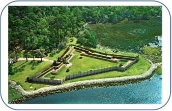
Figure 3 Model of Fort Caroline at the Fort Caroline National Memorial on the St. John’s River in Jacksonville, completed 1957(https://www.floridamemory.com/items/show/328515).
The Fort Caroline Archaeology Project (FCAP)
The research for this paper was carried out by the FCAP established in November 2013 and administered by the Department of Anthropology at the University of Florida with Drs. Anita Spring, Fletcher Crowe, and Barbara Purdy as principal investigators. Fred Cook, a prominent archaeologist of the coast of southeast Georgia, served as senior archaeologist until his death; and William “Bill” Weeks served as consulting archaeologist. Underwater divers included archaeologist Dr. Christopher “Andy” Hemmings, Harley “Guy” Means (Assistant State of Florida Geologist), and Ryan C. Means (Co-Founder of Remote Footprints and Director, Coastal Plains Institute).
1The map of French Florida printed in 1591 attributed to Jacques Le Moyne is well known, but contains the royal arms of Philip II, the King of Spain 1556–98. As well, certain geographical features known only to the Spanish are incorporated into the map. Because the Spanish king's troops massacred the French at Fort Caroline and were hated by the French thereafter, FCAP and others doubt the trustworthiness of the map. The Parreus map of 1563 was published immediately after the Ribault expedition to map the coast of what is today the south Atlantic coast of the United States and is considered more reliable.
2John White, English colonial governor, explorer, artist, and cartographer, sailed with Richard Grenville in the first attempt to colonize Roanoke Island in 1585, acting as artist and mapmaker to the expedition. In 1587, White became governor of Sir Walter Raleigh's failed attempt at a permanent settlement on Roanoke Island, known to history as the "Lost Colony." White is known to have consulted with Jacques Le Moyne in London about the location of Fort Caroline before he drew his map of Florida.
3 Placing the location of Seloy Creek on the north side of St. Augustine has been used to support the argument that Fort Caroline was on the St. Johns.
16thcentury reports on the Fort‘s location
Before launching archaeological investigations, the FCAP conducted a comprehensive study of 16th century materials that provide details and hints to the fort location. Most manuscripts were read in the original sixteenth-century French that provided descriptions of life at the fort that differed from subsequent English translations. Research to examine these documents and maps was conducted at the Bibliothèque nationale de France in Paris, the Library of Congress in Washington, and the Vatican Library in Rome.
Publications consulted include: L’Histoire notable de la Floride by René Goulaine de Laudonnière, the commander of the fort (1564-66);8 the account of Dominique de Gourgues, a French corsair who attacked the fort in 1568 when it was held by the Spanish (1586);9 and Discours de l’histoire de la Floride by Nicolas Challeux, a carpenter at Fort Caroline (1579; printed in 1841).10 Testimonies used include those given by Robert Melenche11 and Stefano Rojomonte included in the compilation Laudonniere and Fort Caroline, edited by Charles E Bennett.12
Also analysized was a Spanish document known as “AGI 212 No. 6” from the Archivo General de Indias of Seville, Spain, collected by Eugene Lyon13 in Spain, as were Histoire de la Floride française by French historian Paul Gaffarel (1875),14 the Parreus map of 1563, and the De Bry map of French Florida4.1
Of particular concern is the translation provided by Charles Bennett in which the French term “lieue” (“league”) is erroneously treated as synonymous with the word “mile.” Samuel Eliot Morison, America's pre-eminent naval historian (1887–1976), who studied the use of the French league in the sixteenth century by French explorers such as Cartier and Cabot, concluded that French explorers at that time, routinely used la petite lieue marine ["the short nautical league"] that was about 2.2−2.3 nautical miles to represent one mile.15 Hence, Bennet’s calculations would be off by a factor of 2.2.
Also used for this paper, and listed in References, was the Ensayo Chronolgico para la Historia General de la Florida by Andres Barcia of 1723, translated by Anthon Kerrigan (1951).16 The 1587 English-language publication Principal Navigations, Voyages, Traffiques and Discoveries of the English Nation by Richard Hakluyt17 was similarly consulted, as was the John White map of 1587.2 Also consulted was Pedro Menéndez de Avilés, Adelantado, Governor and Captain-General of Florida, Memorial by Gonzalo Solis de Meras, translated by Jeannette Thurber; and Les Français en Floride, as well as portions of the record of René de Laudonnière, edited by Suzanne Lusagnet (in French).18 The Hakluyt book contains the record of the raid on the renamed Fort Caroline by the corsair Dominique De Gourges in 1568.
Methods: Underwater Archaeology and Side–Scan Sonar Survey of Rivers
In August 2014, State of Florida underwater geologist Dr. Dan Phelps of the Florida Geological Survey (FGS) conducted a side–scan sonar survey of the bottom of the rivers near the suspected site of Fort Caroline. They detected five “hits” and the FCAP investigated the five “Sites of Interest”. In December 2014, a team from the Bureau of Archaeological Research (BAR) of the State of Florida Division of Historical Resources under the direction of Dr. Roger Smith, along with Dr. Ryan Duggins and Dr. Franklin Pierce, surveyed the areas and rivers of interest using side-scan sonar and magnetometry (Figure 4).
Subsequently, three-dimensional images of river bottoms of interest were scanned using side-scan sonar; and two teams of underwater divers who inspected features of interest in April 2015 and July 2017 by Harley “Guy “Means, Assistant State Geologist, Geological Investigations Section, Florida Geological Survey and Ryan C. Means, Co-Founder of Remote Footprints and Director, Coastal Plains Institute. Two additional underwater dive sessions were carried out by archaeologist Dr. Christopher “Andy” Hemmings and underwater photographer David Uloa (Figure 5).
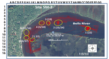
Figure 5 Detailed River Mapping area surveyed using side-scan sonar. (Data Overlay on LiDAR/Remote Sensing by Fletcher Crowe.)
Methods: Analysis of Area Characteristics
The FCAP generated a list of 31 criteria to indicate the location of the fort using the descriptions from the historic materials (Figure 6A & 7). These 31 criteria were grouped into five broad categories: (1) Area Characteristics; (2) Site Characteristics; (3) River Characteristics; (4) Topographical Characteristics; and (5) Location Characteristics. Spring and Crowe found most of these characteristics on the St. Marys River site rather than at the St. Johns site.
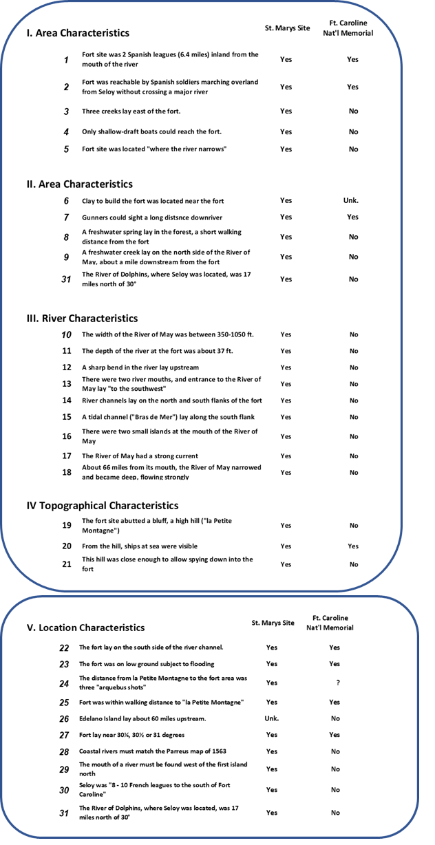
Figure 7 Degree of Consistency Between 31 Criteria and Two Proposed Locations for Fort Caroline. FCAP argues that Fort Caroline was located along the St. Marys River4
Source: Spanish AGI 212 No. 6, Milanich/Lyon
Source: Barcia/Kerrigan, 1723/1951
Source: Laudonnière/Basanier/Hakluyt, 1586; Le Challeux, 1566.
Source: Laudonnière/Bennett, 1586/2000, pg. 93.
Source: Melenche/Bennett, 1586/2000 pg. 90.
Source: Laudonnière in Bennett, 2000, pg. 54.
Source: Melenche in Bennett, 2001, pg. 90.
Source: Le Challeux, 1566; printed in English by Hakluyt 1586.
Source: Le Moyne map of French Florida, printed by De Bry in Latin, 1591.
Source: Spanish AGI 212 No. 6, Lyon/Milanich
Source: Spanish AGI 212, No. 6 Lyon/Milanich
Source: Le Moyne map of French Florida printed by De Bry in Latin, 1591; also shown on the John White map of 1587.
Source: Paul Gaffarel, Histoire de la Floride française, 1875; Melenche/Bennett 1565/2000, pg.90.
Source: Paul Gaffarel, 1875.
Source: Rojomonte/Bennett, 2001, pg.97.
Source: Paul Gaffarel, 1875.
Source: Barcia/Kerrigan, pg. 127; Solis de Meras, pg. 205.
Source: Barcia/Kerrigan, pg. 127; De Meras/Thurber 1964, pg. 205.
Source: Laudonnière/Lusagnet pg. 165.
Source: Laudonnière/Basanier/Hakluyt, 1586, pg.59; Le Moyne/De Bry, 1586.
Source: De Gourgues/Hakluyt, 1586; Laudonnière/Bennett, 2000; Barcia/Kerrigan, 1723/1951.
Source: Bellin map of 1744; De Bry map of French Florida of 1591.
Source: Melenche/Bennett, 2001, pg. 93.
Source: Barcia/Kerrigan, 1723/1951; Le Challeux, 1566; published by Hakluyt 1586.
Source: De Gourgues/Hakluyt, 1586; Le Moyne/De Bry, 1586; Barcia/Kerrigan, (1723/1591).
Source: Barcia/Kerrigan, 1723/1951; Le Moyne/De Bry 1586; Laudonnière/Hakluyt, 1586
Source: Menendez Oct. 15, 1565; Hawkins/Hakluyt 1586; Laudonnière; Lescarbot, 1606; Rojomonte/Bennett 2001; Melenche/Bennett, 2001
Source: Laudonnière; Le Moyne; Parreus map of 1563; De Bry map of French Florida, 1591
Source: See Parreus map of French Florida, 1563
Source: Laudonniere/Hakluyt pg.55; Laudonnière/Lussagnet pg.173.
Source: Laudonniere/Lusagnet pg. 86 and 172; Le Challeux; Laudonniere/Hakluyt pg. 20.
Each of these 31 Criteria was analyzed to determine how closely it matched the St. Johns River site, St. Marys River site, or both using the scoring matrix shown in Figure 6. The evaluations for each of the Criteria are shown in Figure 7. It should be noted that archaeological studies by Ashley and Thunen have concluded that Fort Caroline was not at the site where the FCNM is located, and Dr. Chester DePratter, believes the site washed away.19
The FCAP has used the FCNM site as a reference point; but most of the Criteria would apply to the first six miles of the St. Johns River from its mouth to Blount Island where the river turns sharply to the south. Working against the site as the fort’s location include: the lack of two islands not one at the mouth, the lack of a second parallel channel, the lack of a freshwater channel, and the lack of high speed of the river’s current. None of these factors describe the St. Johns from Jacksonville to the ocean. As seen in Figure 7, the descriptions of the geography near the fort given by French and Spanish writers, do not match the actual geography of the St. Johns River. These descriptions are given below.
Methods: Analysis of French, British, and Spanish Maps
In addition to examining original 16th century documents on the fort’s location, the FCAP examined many early maps of French Florida. Only three are shown here, due to lack of space, but they provide data on the fort’s location. Listed in chronological sequence, the maps are the: (1) 1563 Parreus map; (2) 1587 John White map; and (3) 1744 Nicolas Bellin map.20
The Parreus Map of 1563
In 1562, Jean Ribault arrived from France to explore the coastline and begin a new colony.21 His crew carefully mapped the coast of today’s northeast Florida, Georgia, and South Carolina. This map of the shoreline was published the next year as the Parreus Map (Figure 8). It was drawn for Nicolas Barré (known as “Parreus”) during the 1562 scouting voyage and shows the mouth of a river immediately west of the first island north of the River of May. This locates what is found if the River of May is the St. Marys River, and the first island north is Cumberland Island (Figure 8 at V10).
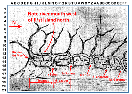
Figure 8 Parreus Map of French Florida, 1563. Shows a river west of the first island north of the River of May. If the River of May is the St. Marys River, this island is Cumberland Island, and the map is correct.
The John White Map of 1587
Further clues for the location of Fort Caroline come from John White’s 1587 the map of French Florida (Figure 10). White was artist and mapmaker for the first expedition to found an English colony in Virginia. He served as governor of the second attempt to found Roanoke Colony in 1587. It is known that he conferred with Jacques Le Moyne in London before sailing in 1587, so the map of French Florida that he drew (Figure 9) may be considered relatively accurate. John White’s map clearly shows the St. Johns River, with its prominent bend to the south, as the River des Daufins (River of Dolphins), which the French wrote was 17 miles north of 30 degrees.
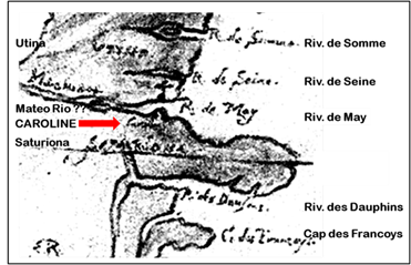
Figure 9 Detail of Southern Portion of Map of North America by John White, 1587. Note that the "R. des Daufins," with its sharp bend to the south, is clearly the St. Johns River.
The Bellin Map of 1744
In 1741, Bellin had become the first “Ingénieur de la Marine of the Dépot des cartes et plans de la Marine” (the French Hydrographical Office). Figure 10 shows his map of southeastern North America. The location is at variance with the location on the St. Johns River. Seen in the detail of the southern portion (Figures 10 & 11), the French cartographer located Fort Caroline about one-tenth of a degree (about 6.9 miles) west of the mouth of the river the Spanish called the San Mateo River, the river today is the St. Marys that forms the border between Florida and Georgia with the Fort on the south Florida side.
Where the lines cross at F13 (Figure 11) it states in French “Ici…la Caroline” that translated states that "Fort Caroline was here" on the San Mateo River, formerly the River of May. The map shows that the St. Augustine River, "today called the St. Johns River," was "formerly known as the River of Dolphins." The cross mark is about one-tenth of a degree (about 6.9 miles) west of the mouth of the San Mateo River (known today as the St. Marys River).
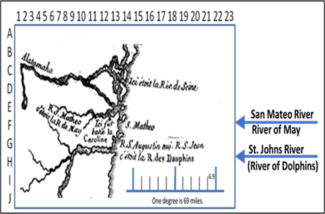
Figure 11 Detail of Southern Portion of Map of French Florida by Jacques-Nicolas Bellin (1744. The French knew the River of Dolphins as the Seloy River. The map clearly shows Fort Caroline well north of the St. Johns River.
The map’s key states that one degree is 25 leagues (about 69 miles). The site of the fort is shown about one-tenth of a degree west of the mouth of the San Mateo River, about 6.9 miles inland.5 The location of Fort Caroline that he gave in the 1744 map does not seem to have appeared in any other published map, but the French explorers who garrisoned at Fort Caroline were members of the French navy, and as director of the French navy's Hydrographical Office, Bellin may have had access to unpublished naval records.
The Location of St. Augustine and the Spanish Attack
In September 1565, five hundred Spanish troops under Pedro Menéndez attacked Fort Caroline. It was reported that they left from “Seloy” and marched north to attack the French on the River of May without crossing a major body of water. Traditionally, it has been claimed that the Spanish began their march near the present city of St. Augustine and moved north to the St. Johns River.
If Fort Caroline was located on the St. Marys River, as proposed here, and if Seloy was at the present city of St. Augustine, the Spanish would have left from the present city of St. Augustine and needed to cross the St. Johns River in boats (Figure 12). The Spanish did not have boats and did not report crossing a large body of water, so the Spanish did not leave from Anastasia Island near modern St. Augustine. Instead, the Spanish left from “Seloy” (the “first St. Augustine” see Figure 13) on the north side of the St. Johns River. Later, after the massacre of the French, some of the Spanish stayed at the fort under the leadership of Stephan de las Alas. Other Spanish left for the location of modern St. Augustine, and proceeded to construct a series of forts, each one called the St. Augustine Fort (Figure 14).
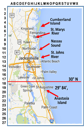
Figure 12 Modern Map of Northeast Florida. The Parreus Map showed a river west of the first island north of the River of May. This map shows such a river west of Cumberland Island (the first island north of the St. Marys River).
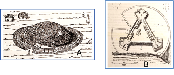
Figure 13 Artist’s Sketch of Seloy Indian Lodge.
Figure 13B Sketch of Fort found by Kathleen Deagan in St. Augustine. (See Figure 15 for dates and construction type.)
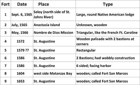
Figure 14 Eight Wooden Forts at St. Augustine Before the Coquina Castillo of San Marcos. Source: Lyon (1979); also compiled by authors, who count the Seloy Round Fort as number one for a total of Nine Wooden Forts.
Distance from Seloy to Fort Caroline
In addition to the analysis of 31 factors, Fort Caroline could not have been located on the St. Johns River based on the writing of French and Spanish eyewitnesses. Still, the prevailing opinion of some historians and the “general public” near the model fort maintained that the fort was on the St. Johns. Why is this and what is the distance that Menendez and his men marched. Congressman Charles Bennett, U.S. House of Representatives from Jacksonville/Duval County wrote a book, Laudonnière and Fort Caroline (1975 reprinted in 2000), that claimed Menendez’s army left to attack Fort Caroline from St. Augustine marching north in four days. However, the distance from the Castillo in St. Augustine to the Fort Caroline National Memorial on the St. Johns River is 35 miles (that would have been a feat in a driving rain for 500 soldiers in the 16th century). Bennett was in effect translating the term “league” as “mile,” (i.e., 35 leagues equaled 35 miles).
However, if Fort Caroline was located on the St. Marys and the Spanish marched north to attack the French, a distance approximately 20 miles would be correct. Laudonnière reported that when Native Americans informed the French that the Spanish had landed, he dispatched Captain Cosette to observe the Spanish fleet’s motives. Cosette reported that the Spanish were “eight to ten leagues” from the French. Samuel Eliot Morison (1978), the dean of American naval historians, said that French naval officers at that time were using a league of about 2.2 to 2.3 miles in length, implying that the Spanish were about 18 to 22 miles to the south – almost the exact distance from the St. Johns River to the St. Marys River and a credible distance for Menendez and his 500 men to march the actual the distance of 20.65 miles in four days in a driving rain storm. This is strong evidence Fort Caroline must have been on the St. Marys. Bennett’ contention of St. Augustine as the origin of the march is incorrect.
In addition, Spanish documents confirm Fort Caroline is on the St. Marys River. One such document written in 1568 that FCAP studied in the Vatican Library in Rome shows that in the collection by Felix Zubliaga (1941) is the report written by Esteven (Stephan) de las Alas on May 5, 1568, ten days after the fort was attacked by Dominique de Gourgues on April 25, 1568.23 Las Alas describes the location of Native American villages such as Utina, Alicamani, and Tacatacuru, and details the location of the two Spanish blockhouses near the mouths of the San Matheo River (i.e., called the River of May by the French).24 With this geographical information, the location of Fort Caroline on the St. Marys River is also confirmed.
After Seloy, the Spanish built eight wooden forts before they erected Fort San Mateo, a fortress constructed of coquina rock. Although documentation on these nine forts (if the round Seloy is included) is sketchy and confusing, but it can be surmised that the first European one was probably the triangular fort6 discovered by Deagan and her team on the grounds of Nombre de Dios, and the next two were built on nearby Anastasia Island, although their exact locations are yet not found. A fourth fort was built in a rectangular shape in 1572 facing what today is Ponce de Leon Circle at the town square of St. Augustine. A sixth fort of an irregular six-sided shape was begun in 1578 facing the harbor; and in 1586 a seventh fort, called Fort San Marcos, was completed. An eighth fort, also called Fort San Marcos, was begun in 1604 and lasted 50 years. Finally in 1672, construction of the famous coquina Castillo was begun, and the fortress was completed in 1695.26 The often called “nine wooden forts” are listed in Figure 14.
4It is clear from the writing of Laudonnière, that Capt. LaCaille, who had studied the language of the Native Americans near Charlesfort, was able to interpret and understand the language of the Indians near Fort Caroline. This, however, has not been used as one of the Criteria to score the location of Fort Caroline.
5The French adopted a distance of 2.76 miles per league well after Fort Caroline had been lost.
6Deagan noted that Menendez used the triangular fort shape for 1565 fort she excavated, similar to the larger French 1564 Fort Caroline (Explore: Research of the University of Florida, Fall 1996, p. 6).
During 2014-2015, and 2017, archaeological site surveys at four locations were conducted by the FCAP and more than 100 shovel test pits (STPs) were excavated. Over 100 artifacts were collected and curated. The FCAP team inspected the artifact collections of four individuals related to nearby sites. Sonar scans of the bottom of St. Marys River, at the suspected fort site, revealed various items of interest, including two stone markers. (Further excavations are planned).
Findings: Side-scan Sonar and Artifacts
Underwater archaeology by Harley Means and Ryan Means recovered objects and artifacts in the waters near the proposed site of the Fort. It should be noted that this area of the St. Marys’ River (unlike the St. John’s River) has a depth of 37.5 feet, a rapid current, and the water is highly tannic. These characteristics are not found on the St. Johns River. The recovered objects included ballast stones, small clay objects, glass bottles of later periods, and a large stone block with a hole that possibly could be part of the French oven. These were deposited with the Florida Museum of Natural History, as required by law. Two wooden pieces collected on land were dated by standard radiocarbon-14 methods by BETA Analytic Inc. One artifact, a wooden piece collected from near the fort’s suspected spring, was sent to Beta Analytic Inc. and generated a carbon-14 date of 1530-1600 (±100 years, the standard designation in dating), which is within the time-period of Fort Caroline (1560s).
Private contract archaeologists located a burial mound in a nearby area that appears to contain a 16th century French halberd, a type of weapon that reportedly was given to a Native American warrior by the French in 1568. Cook (2015) cites the work of the archaeologists on this subject.27 In addition, the burial mound contains other European items such as a curved knife, iron implements, and chevron and other beads that replicate the gifts noted in the literature from the French for assisting de Gourgues in the attack of 1568 on the Spanish-held Fort Caroline (Note: Under FCAP’s non-disclosure agreement, the site and archaeologists cannot be disclosed).
Three-dimensional images of the bottoms of rivers were generated using side-scan sonar and divers visually inspected underwater features of interest (Figure 15).

Figure 15 LIDAR Image West of the Mouth of the St. Marys River. The 1744 map of French Florida by Nicolas Bellin located Fort Caroline about 6.9 miles west of the mouth of the River of May, called the San Mateo River by the Spanish. The resolution of LiDAR images from fixed-wing aircraft and satellite remote sensing is too low to detect indications of the fort site.
Findings: Scoring the Criteria and Characteristics
Figures 6B & 7 shows that the traditional location of the St. Johns River scored 9 "Yes" evaluations, while the St. Mary scored 30 "Yes" evaluations. In comparison with the St. Marys site, the St. Johns site lacked many characteristics and was not consistent with the fort’s location given in the body of literature and maps. Note that most of the factors that reference the Fort Caroline National Memorial site apply to the entire stretch of the St. Johns River east of Jacksonville. For easy comparison, the following differentiate major germane defining characteristics of the two rivers.
The St. Johns River:
Only the St. Marys has
Findings: from Analysis of the Maps
Analysis of early maps allows the Fort Caroline Archaeology Project to conclude that Fort Caroline was not located near present-day St. Augustine. The John White map of 1587 clearly shows Fort Caroline well north of a river that can only be the St. Johns River. The Lescarbot map of French Florida, dated 1617, shows quite distinctly the River of May is where Fort Caroline was situated well north of the River of Dolphins, where Seloy was located. A map of French Florida by Jacques-Nicolas Bellin, dated 1744, likewise placed Fort Caroline clearly north of the St. Johns River. The conclusion seems inescapable: these geographers and historians did not think Fort Caroline was located on the St. Johns River.
Sea Level Increases and LIDAR
Fort Caroline was built so close to the water's edge, that the French reported that one corner of the structure routinely flooded. Therefore, if the sea level has risen in recent centuries, does the site today lie underwater? The FCAP believes that rising sea levels have not yet flooded the site of Fort Caroline, and the site does not lie underwater today. As seen in Figure 16, global sea levels are estimated to have risen about 14cm (5.6 in.) since 1900, but between 1564 (when Fort Caroline was constructed) and 1900, global sea levels fell substantially.28 Therefore, the net increase in global sea levels, 1564 to 2000, has probably been only about 7 cm. (2.8 in.), not an increase great enough to inundate the fort site with water.
The findings of this study show that the geographical features reported by 16th century French sources are consistent with the location of Fort Caroline on the St. Marys River, and not consistent with the St. Johns River. Thirty-one criteria considered area, site, river, topographical, and location characteristics. In summary, the French reported that the River of May had two mouths (#13) that are still there today, while the St. Johns River has only one mouth. The St. John’s site does not have a sharp bend in the river upstream from the fort (#12) and does not narrow at the fort site (#5). The St. Johns has no tidal channel/Bras de Mer (#15). Upriver segments of the St. Johns do not match the reported description of the River of May (# 18). The French reported a strong current for the River of May; the St. Marys has a strong current (#17), unlike the wide (#10), slow-moving St. Johns River. And so as detailed above and taken together, these characteristics support the St. Marys location for Fort Caroline.
Early maps position Fort Caroline further north than the St. Johns River. The Bellin map of 1744 (Figure 11 & 12), located Fort Caroline about one-tenth of a degree (6.9 miles) west of the mouth of the river the Spanish called the San Mateo River, today’s St. Marys River. The Parreus Map of 1563 shows a river and an island that corresponds to Cumberland Island north of the St. Marys River; and the John White map of 1587 (Figure 10) clearly shows the River of Dolphins as the St. Johns River, with the River of May, where the fort was, considerably north of that river.
The factors that argue for the St. Johns River are a result of incorrect translations of 16th-century measurements by various authors in the 19th and 20th centuries. Of particular concern is the translation provided by Charles Bennett (2001) where he translates the French term “lieue” (“league”) as “one mile.” Samuel Eliot Morison, America's pre-eminent naval historian (1887–1976), studied use of the French league in the 16th century by French explorers, and concluded that French explorers at that time routinely used “la petite lieue marine" [the “short nautical league”] that was about 2.2–2.3 nautical miles, to represent one league.
Finally, the authors believe that the data presented here show why searching the St. Johns River area for Fort Caroline has not yielded results. For future research, the FCAC intends to locate the remains of the fort by utilizing high-resolution drone-mounted LiDAR with renderings that generate about 1500 data points per square meter (4-5 cm or 1.5-2 in) that yield accurate results. Even though high tides, floods, and hurricanes have served to wear down the embankments of the fort’s palisades, a resolution of 4-5cm may be able to detect surface features revealing the location of the fort and internal buildings. Moreover, LiDAR can show variations in foliage, and the coloration of plants growing above the location of the structure’s ramparts to indicate the Fort’s outline.
Fort Caroline was founded by French explorers under René Goulaine de Laudonnière on June 22, 1564 on the “River of May” in “French Florida.” On September 20, 1565, 15 months later, Spanish forces under Pedro Menendez marched north from Seloy in four days, attacked the fort killing 132 men, and scattered the remaining people. The data here show that Seloy was located on the north side of the St. Johns River, not near the Nombre de Dios Catholic mission on the north side of modern-day St. Augustine.
Subsequently, Menendez learned from Native American “spies” that Jean Ribault’s French fleet was sailing from France up the Florida coast. Menendez immediately set out to attack the fleet. Then, on October 12, 1565, on the beach south of modern-day St. Augustine, now called Matanzas (Spanish for “slaughter”), the Spanish under Menendez killed the French, one by one, and sent the women and children they had captured by ship to Havana (some decades later, pirates burned and destroyed genealogical records that might have had information on their arrival and fate).
After the September 20, 1566 massacre at Fort Caroline, with the Spanish in charge, Menendez left Stephan de las Alas as regional commander. He and his soldiers built two blockhouses near the two mouths of the St. Marys River (the St. Johns’ River only has only mouth.) The Spanish renamed the River of May the “San Mateo River.” As relations with the neighboring Indians deteriorated, in May 1566, less than a year after the Spanish attack, Menendez moved some Spanish soldiers south to a more defendable position near modern St. Augustine where they would not be easily attacked by ships coming from the ocean.
On April 25, 1568, a band of French corsairs under Dominique de Gourgues arrived at Spanish-held Fort Caroline, now called Fort San Mateo. His men attacked the two blockhouses and main fort. They proceeded to hang the Spanish and dumped Spanish cannons in the river. Fort Caroline was burned and abandoned by the Spanish in 1572.
Menendez, who had been named Adelantado or Governor of Florida, had been given jurisdiction over the territory by Spain, to explore and claim territory, collect taxes, commandeer labor, and build structures. Remains of a triangular Spanish fort have been found by archaeologist Dr. Kathleen Deagan and her associates on the grounds of the Nombre de Dios Catholic mission on the north side of St. Augustine, Florida; it has been called the first Spanish fort (as has Seloy a Native American-built structure), built immediately after the Spanish landed in the New World. The FCAP believes this structure was erected after the Spanish massacre of Ribault and his men. The Spanish went on to build seven or eight more wooden forts in and near St. Augustine before the present-day Coquina Castillo San Marco was begun in 1653.
In 1572, four years after de Gourgues’ attack, the Spanish settlement on the “San Mateo River” was relocated to the mainland near modern St. Augustine. On September 17, 1574, Menendez fell ill and died. The former French, then Spanish, Fort Caroline was abandoned by the Spanish. The location of Fort Caroline has remained an enigma in American archaeology.
All archaeological work of the FCAP has been conducted under a legally-binding, Non-Disclosure Agreement (NDA) to guarantee confidentiality of sites being investigated. The exact location is not provided here and can only be released with full protection by the Florida Division of Historical Resources.
The authors wish to thank the Felburn Foundation for its support to the Fort Caroline Archaeology Project.
The authors declare there are no conflicts of interest.
The Felburn Foundation; Anne Reynolds Foundation.

©2022 Spring, et al. This is an open access article distributed under the terms of the, which permits unrestricted use, distribution, and build upon your work non-commercially.