eISSN: 2469-2794


Research Article Volume 12 Issue 4
Professor Master of Gender, Department of Social Sciences, National University of Luján, Argentina
Correspondence: Mariano Sergio Ramos, Professor Master of Historical Archeology Faculty of Philosophy and Letters, University of Buenos Aires, Professor Master of Gender, Department of Social Sciences, National University of Luján, Member of Center for Historical Archeology Studies, Faculty of Humanities and Arts, National University of Rosario, Argentina
Received: December 04, 2024 | Published: December 20, 2024
Citation: Ramos MS. Scientific method and observation. Field work and planning. Cases of archaeology, ecology and museology. Forensic Res Criminol Int J. 2024;12(4):266-272. DOI: 10.15406/frcij.2024.12.00429
In this paper I analyze some ways of approaching space in a field investigation, through checkerboard-shaped grids with their cells or squares. I discuss the validity of applying this modality in research cases from different disciplines and their results. For these cases I include aspects of justification of the procedure, planning, observation and analysis of the space considering the presence of some elements, their interrelationships and intervening variables.
Keywords: method and procedure, field work, addressing space, analysis, results
Research resources: “looking at what others do”
Resources to apply in field work
Considering these general questions, and the theoretical formulations of other disciplines, I will take three cases of relatively similar resources applied in: 1. Archaeology; 2. Ecology-biology; 3. Museology-museography. All three are based on some theoretical principles and, on the other hand, use similar ways to analyze the presence and distribution of objects or species (such as trees, for example) and a set of variables to which they are subjected. Some, as in the archaeological case, can be included as agents of formation and transformation. Others include influences from other biological and natural agents of different scope. Systems Theory, or whatever one believes may be most useful, can be used to observe the different functionings and establish comparisons between aspects of different cases.
Since the 19th century, field archaeologists – mainly from Europe and America – segmented the space where they were going to carry out their field work, whether to carry out excavations, surveys or surveys. They did it for better observation and analysis of the presence and distribution of the objects they were finding. Thus they divided the space under study using a grid, like a chess or checkers board, selecting the number of squares, boxes or squares that they were going to use. This space to investigate could exceed the total number of the original board (64) or take a smaller portion depending on the complexity of the type of site to be excavated. These plans covered certain technical excavation units, such as grids that, according to the archaeological school to which the archaeologist adheres, could be subdivided into four equal parts such as sectors and these in turn into other smaller, equal portions, such as quadrants. , For example. It involves locating the findings in horizontal and vertical space - as the excavation deepens - and observing the presence of certain objects (which in turn are classified into types); how they are distributed (where they appear) and their associations (close relationships with other objects). In these plans designed to develop field work, archaeologists use the criterion of proximity between finds and, thus, we can make density calculations (number of units according to a spatial measurement, for example, m2). This allows us to apply the comparative criterion. Compare between zones or areas that present different densities and different types of objects found, which allows us to determine areas of greater human occupation, for example. Finally we make an interpretation or explanation of the entire set and begin to evaluate the intervention of agents that could have affected the material integrity of the objects found as well as displaced them – horizontally or vertically – from their original locations. At that moment, the study of the formation and transformation agents (physical, chemical, natural, anthropic, etc.) that affected the archaeological record or the set of findings at a given site comes into play, that is, our source of material information.
Archaeology: the case of the vuelta de obligado site
In 2000 we began field work at the archaeological site of the Vuelta de Obligado battle included in the so-called Paraná War, developed between 1845 and 1846. The research was pioneering in Argentina from the perspective of the so-called Historical Archeology.6–8 This study addresses this conflict between the Argentine Confederation and the alliance made up of England and France, who wanted to impose by force their particular “free trade” throughout the world. The war includes many operations such as the blockade of the Río de la Plata; four battles such as Vuelta de Obligado and Tonelero in the Province of Buenos Aires, in addition to Quebracho and San Lorenzo in the Province of Santa Fe. Likewise, skirmishes and other war events developed in the waters of the Río de la Plata and the Paraná and in various places located on land. The conflict in the so-called Banda Oriental, Uruguay, was not unrelated to this general context of confrontations.
Since May 2000 we have applied several procedures to obtain the material record, our source of information, from the Vuelta de Obligado site. Thus we excavated about 500 m2 using grids; We carried out about 300 trenches and surveys covering a similar area and more than 3000 m2 of surface collections. As a result, we were able to determine several core aspects of the battle. This is how we call those places in which fighting took place with greater intensity and which left as a correlate an important archaeological record that we measure in the number of objects or fragments of them per unit of surface (m2) and then applying the comparative criterion. The total findings from the Vuelta de Obligado site reach around 10,000 whole and fragmented objects. Figures 2–5 show the gridding in the field and interpretations of some findings and their relationships.
Comment
Since May 2000, the use of the checkerboard grid system (Figures 3–6) in what was the Vuelta de Obligado battlefield, allowed us to address a complex site. It was not the only field resource applied at the site (also surveys, trenches and transects). The extensive excavations carried out on the site, using grids, covering almost 500 m2, gave promising results, which can be seen in the presence and distribution of the finds and the consequent interpretations.
Ecology-biology: forests and trees
Two ecologists,9,10 developed a very simple model about what happens in forests and the way in which they self-organize. Although the model is simple, it accounts for the most important biological processes produced in the system investigated. Both studied the forests of Barro Colorado Island in Panama. They found a potential relationship between the frequency of gaps of different sizes and the size of those gaps. Furthermore, they developed an equation that is summarized in
Frequency = constant x (span size) D. With a value of D = 1.74, which indicates that the larger the clearing, the fewer clearings of that size.10
Manrubia9 proposed a model called “forest game” which consists of imagining the forest as a super board similar to that of a chess, but with many more squares (there can be thousands). It is considered that in each empty square a tree sapling can appear with a certain probability. When a tree occupies a square, it does so following a simple rule: an amount is added to its mass, but that amount depends on what is in the eight neighboring squares. Thus, the larger the trees in those squares are, the less the tree in the central square will grow. On the other hand, each tree can die according to a draw that is done periodically. When it grows to a predetermined size, the tree inevitably dies. When each tree dies – the one that when it falls can knock over the neighbors – it leaves a clearing. Consequently, the size of that clearing is represented by the number of squares it affects, and is proportional to the size of the tree when it dies. According to time segments, what will happen in the next step is calculated for each square and the forest plan is updated with all that information. In this exercise there is no force outside the forest itself (storms, winds, fires, predators), there are only the trees growing and competing with each other and the effect of that competition manifests itself in less growth (Momo 2019). And here chance is located with respect to two processes, the probability of death before the maximum size of the tree is reached and the probability that the sapling repopulates an empty square. This compartmentalization in the form of a board allows the “box-counting” method to be applied11 (Figure 6–8).
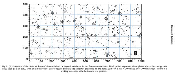
Figure 6 Image of a tropical rainforest area on the island of Barro Colorado, Panama. It shows the presence and distribution of plant species (Manrubia and Solé 1996: 527). The soft blue lines that start from the values that indicate the X and Y axes were incorporated into the drawing - by the author of this work - for better observation by the reader.
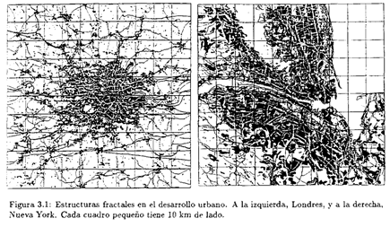
Figure 7 Fractal structures in two cities. In Order and chaos in complex systems. Applications, by Solé and Manrrubia 1993: 78.

Figure 8 The construction of the forest model according to some specialists. In image a you can see the connection of neighboring cells, on the one hand; The arrows between small trees indicate that they can set each other on fire. In b, the little trees were replaced by black dots; The board is 10 x 10 and the probability of occupation of a combustible site is 0.26; In image c the lines that mark the possible paths of the fire are indicated; that is, the map of possible fires. Taken from Momo 2019: 43.
Comment
As can be seen in Figures 7, 8 and 9, the aim is to analyze certain areas that present species or activities of human beings, as may be the case in the two cities. In all three cases there is biological activity, whether in a “dynamic” or almost “static” situation that is finally activated. The cases can be approached from systems theory and can be approached using checkerboard-shaped structures. This allows the space under observation to be better organized: 1. Presence or absence of certain items (plant species, human works); 2. Neighborhood relationships and interactions between those items; 3. Observations, and probabilities, regarding what happens in proximity to each species - or work carried out by human beings - that is part of the groups.
3Museology-museography: Objects and the sex-gender category
A few years ago we began an investigation in rooms of some museums in Argentina. Our purpose12–14 aimed to study museum rooms to analyze what was happening with respect to the exhibited collections. Consequently, we decided to address and analyze aspects in certain museums that included everything from the name of the room to elements and photographs linked to women. On the other hand, they also highlighted the traditional roles that those women had fulfilled during the late 19th century and almost the entire 20th century. That is, we were not going to observe gender issues in those rooms – in the senses conferred by Western thought and reflections at the end of the 20th century – but rather something close to what we can consider as elements and references to sex-gender.12–14 This type of studies covers concepts and scope of: method; material and symbolic heritage; gender and sex; social sectors -or classes-; traditional views during the 19th century and much of the 20th century; private and official local museums. For this paper we will take: The faces of the Pampa of Villa Lía and the Güiraldes Museum in San Antonio de Areco. It is worth saying that we carried out this analysis of several Buenos Aires museums at the beginning of the second decade of the 21st century.
For a better spatial approach, the rooms under analysis were gridded – digitally – in the form of a checkerboard, as we do in an archaeological excavation, and divided into a certain number of cells according to the dimensions of the environment. Once located in the museum environment, we set out to observe and record the presence of certain objects for which we chose to place them within three categories according to attribution in those periods (19th and 20th centuries): 1. female; 2. masculine and 3. Indistinct or neutral. On the one hand, we observed the period contexts, the changes, and eventual reconversions of some elements, which we took into account. Also, from a broader spatial scale perspective, we observe the location of the objects in the room according to the Central Place Theory,15 on the other hand, their locations according to proximity to accesses, or more exposed or more exposed places. “hidden”, “islands”, with more or less lighting. Below are the results of this checkerboard structuring and some observations (Figures 9–14) (Table 1, 2).
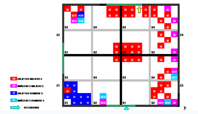
Figure 9 Women of the Landowners Room in the Faces of the Pampa Museum, Villa Lía, San Antonio de Areco.
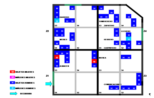
Figure 10 Women of the Landowners Room in the Faces of the Pampa Museum, Villa Lía, San Antonio de Areco .
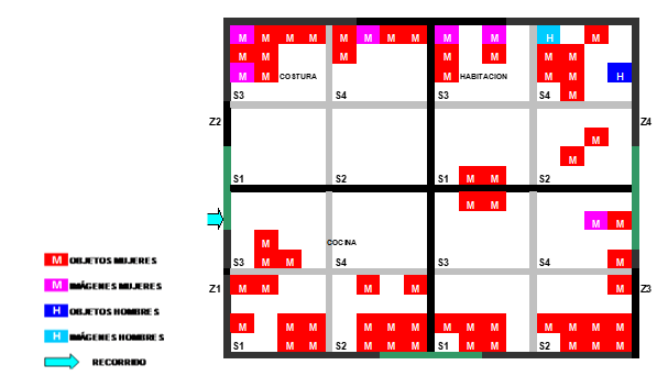
Figure 11 Room Daily life of immigrant women in the Faces of the Pampa museum, Villa Lía, San Antonio de Areco.
|
Type and use of object |
Faces of the Pampa Museum |
||
|
Rooms and % |
|||
|
De la mujer terrateniente (wealthy) |
De los oficios |
Vida cotidiana de la mujer inmigrante (poor) |
|
|
Feminine use |
72 |
4 |
96 |
|
Male use |
15 |
96 |
4 |
|
Feminine and masculine use |
13 |
0 |
0 |
|
Total |
100 |
100 |
100 |
Table 1 . Sharp division of social classes exhibited in this museum; 2. It gives an account of the social reality and two classic stereotypes in the society of the late 19th and early 20th centuries: the women of landowners, with high social positions, and poor immigrant women
|
Type and use of object |
Creole Park and Ricardo Güiraldes Gaucho Museum |
||
|
Rooms and % |
|||
|
Ricardo Güiraldes |
Del estanciero |
Adelina del Carril |
|
|
Feminine use |
0 |
0 |
5 |
|
Male use |
100 |
100 |
92 |
|
Feminine and masculine use |
0 |
0 |
3 |
|
Total |
100 |
100 |
100 |
Table 2 Synthesis in 3 rooms of the Ricardo Güiraldes Creole Park and Gaucho Museum
Comment
In the museum rooms we propose a gridded scheme with squares. Regarding the museum The Faces of the Pampa of Villa Lía, San Antonio de Areco, in the Women of the Landowners, Rich room, it is assumed that the room is dedicated to them; However, in some sectors there are male elements. In relation to the trades room, it would seem that, at the beginning of the 20th century, all trades had been male, with some exceptions. In the Immigrant Woman (poor) room, there is an overwhelming presence of feminine objects and symbols.
In the case of the Ricardo Güiraldes Criollo Park and Gaucho Museum, the Ricardo Güiraldes 1 and Estanciero rooms show that 100% of the objects are associated with men's activities. The Adelina del Carril room, supposedly dedicated to her, is dark and attracts very little attention due to the nature of the objects on display, which do not allow for the organization of a conceptual plot. On the other hand, there are no objects or references to her or women of her time, only some photos of her engagement with Güiraldes. 5% are female objects and 3% belong to this couple, while 92% are male objects. Likewise, there is no relationship, articulation or narrated story between the objects on display and the character. Her omission is part of an identity: she is the “writer's wife.” She was a woman who wrote, who had independent thinking; However, there are hardly any vestiges of her and she has no identifying expressions in a room that bears her name.
In this paper I briefly analyzed a certain planning to address space in field work. I included cases from different disciplines where squares with their corresponding squares of regular dimensions (width = length) were used. The general theme is oriented towards the observation of the use of space by some species -human beings with their objects and trees- and the analysis of presence and consequent distribution. I am interested in the observation of the presence of some elements, their interrelationships; In some cases, the variables that intervene generating processes that affect those objects to move them, both vertically and horizontally, or that can affect their integrity and that of those that are in proximity. These spaces can be addressed in the field by means of checkerboard-shaped grids with their corresponding cells or squares, as was carried out in these investigations. This is because:
Some observations that can be made about this method of planning field work:
To carry out a certain investigation, as in the three cases of the disciplines that we gave as examples, the checkerboard cell shapes can work very effectively as a first approach applicable to any field study. Thus, the grid systems applied in the different studies are simply technical units that can be used if we do not have visible structures. Therefore, and in the particular case of archaeological sites, although it is imperative to bring programming to the field, we must be open to the fact that ultimately it is “the archaeological record that rules…”, and it is the one that, based on The findings can influence us to reorient our field planning.
None.
The author declares there is no conflict of interest.

©2024 Ramos. This is an open access article distributed under the terms of the, which permits unrestricted use, distribution, and build upon your work non-commercially.