eISSN: 2576-4543


Review Article Volume 7 Issue 3
1Green Land Landscaping and Gardening, Seedling Growth Laboratory, Brazil
2Department of Marine Science, University of Calcutta, India
3Department of Management, Techno India University, India
Correspondence: Ricardo Gobato, Green Land Landscaping and Gardening, Seedling Growth Laboratory, 86130-000, Parana, Brazil
Received: May 10, 2023 | Published: July 12, 2023
Citation: Gobato R, Mitra A, Mullick P. Extratropical cyclone in the South Georgia and south sandwich islands and double spiral galaxies. Phys Astron Int J. 2023;7(3):157-161. DOI: 10.15406/paij.2023.07.00303
The work is focused on the comparative analysis of the shape of spiral galaxies and the subtropical cyclone that formed north of Georgia Island and passed north of the South Sandwich Islands, in the South Atlantic Ocean. Subtropical cyclones with double spirals appear to be common in these areas of the South Atlantic. A subtropical cyclone is a weather system that has some characteristics of a tropical cyclone and some characteristics of an extratropical cyclone. They can form between the equator and the 50th parallel. In mathematics, a spiral is a curve, which emanates from a point, moving farther away as it revolves around the point. The characteristic shape of hurricanes, cyclones, typhoons is a spiral. The characteristic equation of which spiral the Extratropical Cyclone (EC) Its double spiral shape, whose mathematical equation has already been defined as Cote’s spiral, Gobato et al. (2022) and similarly Lindblad1 show shape of double spiral galaxies, already studied among others is discussed here.
Keywords: Galaxy, South Georgia and the South Sandwich Islands, Subtropical cyclone, Double spiral galaxy
The South Georgia Group lies about 1,390 km (860 mi; 750 mi) east-southeast of the Falkland Islands, at 54◦-55◦S, 36◦-38◦W. It comprises South Georgia Island1 itself, by far the largest island in the territory, and the islands that immediately surround it and some remote and isolated islets to the west and east-southeast. It has a total land area of 3,756 square kilometers (1,450 sq. mi), including satellite islands, but excluding the South Sandwich Islands, which form a separate island group.2 A cyclone is a large air mass that rotates around a strong center of low atmospheric pressure, counterclockwise in the Northern Hemisphere and clockwise in the Southern Hemisphere as viewed from above (opposite to an anticyclone).3-8 A subtropical cyclone is a weather system that has some characteristics of a tropical cyclone and some characteristics of an extratropical cyclone. They can form between the equator and the 50th parallel.3,7,9-14
These storms usually have a radius of maximum winds that is larger than what is observed in purely tropical systems, and their maximum sustained winds have not been observed to exceed about 32 m/s (64 knots). Subtropical cyclones sometimes become true tropical cyclones, and likewise, tropical cyclones occasionally become subtropical storms. Subtropical cyclones in the Atlantic basin are classified by their maximum sustained surface winds: Subtropical depressions have surface winds less than 18 m/s (35 knots), while subtropical storms have surface winds greater than or equal to 18 m/s.7,8,13,15-26
Tropical cyclones are compact, circular storms, generally some 320 km (200 miles) in diameter, whose winds swirl around a central region of low atmospheric pressure. The winds are driven by this low-pressure core and by the rotation of the Earth, which deflects the path of the wind through a phenomenon known as the Coriolis force. As a result, tropical cyclones rotate in a counterclockwise (or cyclonic) direction in the Northern Hemisphere and in a clockwise (or anticyclonic) direction in the Southern Hemisphere.7,8,13,15-26 The occurrence of cyclones is relatively common for the region at this time of year, but the recent phenomenon has been exacerbated by other meteorological and atmospheric factors. This phenomenon, with this feature to lower the pressure inside quickly generates very strong winds and so that name of explosive cyclones.10-13,16 For large-scale occurs, the subtropical cyclones influence and are influenced by the weather and other atmospheric phenomena point of view, the call synoptic condition.27
In mathematics, a spiral is a curve, which emanates from a point, moving farther away as it revolves around the point.28-30 The characteristic shape of hurricanes, cyclones, typhoons is a spiral,7,8,13,27,31-37 are several types of turns, and determining the characteristic equation of which spiral the cyclone bomb (CB)38 fits into is the goal of the work. Spiral galaxies form a class of galaxy originally described by Edwin Hubble in his 1936 work The Realm of the Nebulae and, as such, form part of the Hubble sequence. Most spiral galaxies consist of a flat, rotating disk containing stars, gas and dust, and a central concentration of stars known as the bulge. These are often surrounded by a much fainter halo of stars, many of which reside in globular clusters.39
Spiral galaxies are named by their spiral structures that extend from the center into the galactic disc. The spiral arms are sites of ongoing star formation and are brighter than the surrounding disc because of the young, hot OB stars that inhabit them.39-42
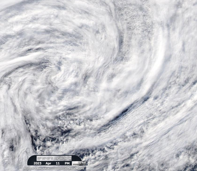
The core of cyclone presents the form of a double spiral, Figures 1-3, in the same way the study of the spiral of the galaxies of Lindblad1,43 figure 4 & 5. This spiral is denoted from Cotes Spiral Gobato et al.11-16,23-25,28-30

Figure 1 Image of Georgia, scale 1:200, on April 11, 2003, PM, and nucleus at the coordinates given in the image.45 [Authors]

Figure 2 Image of Georgia, at scale 1:20, on April 11, 2003, AM, whose nucleus was at the approximate coordinates of those in the image.45 [Authors]

Figure 3 Image of Georgia, scale 1:20, on April 11, 2003, PM and nucleus at the coordinates given in the image.45 [Authors]

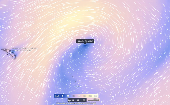
Figure 5 Image of Georgia, scale 1:100, in surface wind model generated by the Zoom Earth system, on April 11, 2003, 12:00, with 5km/h WSW, and nucleus at the coordinates given in the image.41
Spiral galaxies
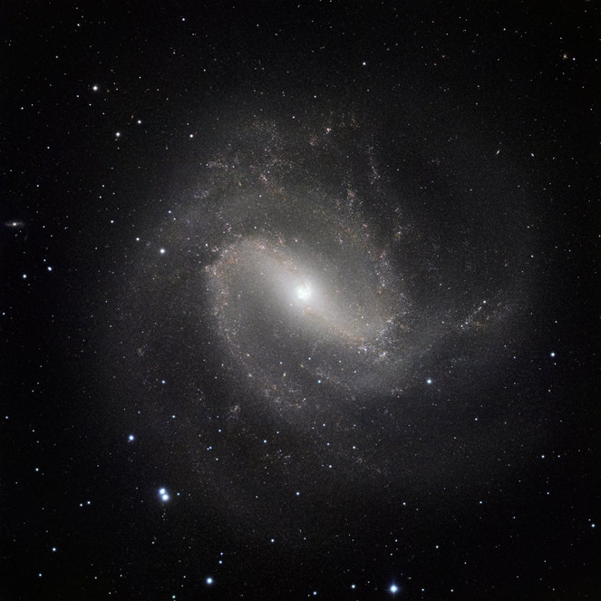
The Figure 6 show spectacular spiral galaxies using the impressive power of the HAWK-I2.50,51

Figure 6 Image of the nearby galaxy Messier 83 was taken in the infrared part of the spectrum with the HAWK-I instrument on ESOs Very Large Telescope. The very fine image quality of this camera, coupled with the huge light-collecting power of the VLT, reveals vast numbers of stars within the galaxy. The images were taken in three different parts of the infrared spectrum and the total exposure time was eight and a half hours, split into more than five hundred exposures of one minute each. The field of view is about 13 arcminutes across.50,59
Messier 83 (The Southern Pinwheel)
The Figure 7 show Hubble image captures hundreds of thousands of individual stars, thousands of star clusters and hundreds of supernova remnants in the spiral galaxy M83. Also known as the Southern Pinwheel, this galaxy is located 15 million light-years away from Earth in the constellation Hydra. It was discovered in 1752 by the French astronomer Nicolas Louis de Lacaille. With an apparent magnitude of 7.5, M83 is one of the brightest spiral galaxies in the night sky. It can be observed using a pair of binoculars most easily in May. [49], [50]

Figure 7 Hubble image captures hundreds of thousands of individual stars, thousands of star clusters and hundreds of supernova remnants in the spiral galaxy M83. Also known as the Southern Pinwheel, this galaxy is located 15 million light- years away from Earth in the constellation Hydra.50
Hubbles image reveals interstellar bubbles produced by nearly 300 supernovas. By studying these supernova remnants, astronomers can better understand the nature of the stars that exploded and dispersed their nuclear processed chemical elements back into the galaxy, contributing to the next generation of new stars.
A. NGC 1566
NGC 15663, sometimes known as the Spanish Dancer, is an intermediate spiral galaxy in the constellation Dorado, positioned about 3.5◦ to the south of the star Gamma Doradus. It was discovered on May 28, 1826 by Scottish astronomer James Dunlop. At 10th magnitude, it requires a telescope to view. The distance to this galaxy remains elusive, with measurements ranging from 6 Mpc up to 21 Mpc.53,54 The small but extremely bright nucleus of NGC 1566 is clearly visible in this image, a telltale sign of its membership of the Seyfert class of galaxies. The centers of such galaxies are very active and luminous emitting strong bursts of radiation and potentially harboring supermassive black holes that are many millions of times the mass of the sun.53,54
NGC 1566 is not just any Seyfert galaxy; it is the second brightest Seyfert galaxy known. It is also the brightest and most dominant member of the Dorado Group, a loose concentration of galaxies that together comprise one of the richest galaxy groups of the southern hemisphere. This image highlights the beauty and awe-inspiring nature of this unique galaxy group, with NGC 1566 glittering and glowing, its bright nucleus framed by swirling and symmetrical lavender arms.53,54
The HAWK-I instrument mounted on the telescope’s Nasmyth (side) port. HAWK-I is attached on Yepun, Unit Telescope number 4 of ESO’s Very Large Telescope and saw First Light on the night of 31 July 2007. HAWK-I covers about 1/10th the area of the Full Moon in a single exposure. It is uniquely suited to the discovery and study of faint objects, such as distant galaxies or small stars and planets Figure 8.

Figure 8 Hubble image shows NGC 1566, a beautiful galaxy located approximately 40 million light-years away in the constellation of Dorado (The Dolphinfish). NGC 1566 is an intermediate spiral galaxy, meaning that while it does not have a well-defined bar-shaped region of stars at its center like barred spirals it is not quite an unbarred spiral either. 53,54
Analisys
The Figure 1 show the image of Georgia, scale 1:200, on April 11, 2003, PM, and nucleus at the coordinates given in the image.
The Figure 2 show the image of Georgia, at scale 1:20, on April 11, 2003, AM, whose nucleus was at the approximate coordinates of those in the image.
The Figure 3 the image of Georgia, scale 1:20, on April 11, 2003, PM and nucleus at the coordinates given in the image. The Figure 4 show the image of Georgia, on a 1:100 scale, in an atmospheric pressure gradient model generated by the Zoom Earth system, on April 11, 2003, 12:30, with 951 mbar, and whose core was located at approximate coordinates of image.
The Figure 5 the image of Georgia, scale 1:100, in surface wind model generated by the Zoom Earth system, on April 11, 2003, 12:00, with 5km/h WSW, and nucleus at the coordinates given in the image.
The mathematical model44 for the atmospheric pressure gradient in Figure 5, used by Zoom Earth42 matches the correct way to scale the atmospheric pressure, as can be seen in the comparison of the satellite images in Figures 1 and 2.
The model of wind currents Figure 4, for the displacement of air masses observed in the images is consistent with that observed in Figures 2-3, which presents a great turbulence in the vortex.
The highlighted cyclone vortex Figures 2 and 3 still in turbulent formation presents two linear containment barriers, in an L shape.
The subtropical cyclone that formed northwest of South Georgia & South Sandwich Island is here called Georgia. It moved 237 km in 12 h towards the West, when it was 589 km from South Georgia Island, to 809 km from the center of the coast of the South Georgia Island. During this time interval, it maintained an atmospheric pressure at sea level at its vortex close to 951 hPa. It presented rotational winds of 5 km/h approximately 8 km from the central vortex.
With an approximate dimension of 1,000,000 km2, and an area of direct influence of 3,500,000 km2, the subtropical cyclone Georgia moved at an average speed of 19.75 km/h.
The mathematical model for the atmospheric pressure gradient in Figure 5, used by ZoomEarth42 matches the correct way to scale the atmospheric pressure, as can be seen in the comparison of the satellite images in Figures 1 and 2.
The model of wind currents Figure 4, for the displacement of air masses observed in the images is consistent with that observed in Figures 2 and 3, which presents a great turbulence in the vortex.
The highlighted cyclone vortex Figures 2 and 3 still in turbulent formation presents two linear containment barriers, in an L shape.
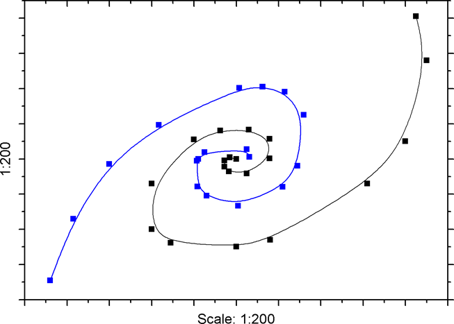
Figure 9 shows Georgia’s double spiral shape at 1:200 scale. The graph was constructed from satellite images, Figures 1-3, with cloud streams formed by wind currents in Georgia.

Figure 9 Image of Georgia, scale 1:100, in surface wind model generated by the Zoom Earth system, on April 11, 2003, 12:00, with 5km/h WSW, and nucleus at the coordinates given in the image. [Authors]
The analogous shape of Georgia and the galaxies Messier 83 and NGC 1566, studied here, is clear. These present a double spiral, as studied by Lindblad,1 but with the Cote’s spiral form, Gobato et al.12,13,16
Table 1 shows the coordinates of Georgia, between April 11, 2023, AM and PM, which Georgia maintains, a central vortex pressure of 951 mbar, with an approximate dimension of 5 km.
April 11, 2023 |
Coordinates |
Pressure (hPa) |
AM |
53◦13’09”S 27◦45’05”W |
951 |
PM |
53◦16’42”S 24◦00’38”W |
951 |
Table 1 Subtropical Cyclone Georgia: Location/Pressure
1South Georgia and the South Sandwich Islands is a British Overseas Territory in the southern Atlantic Ocean. It is a remote and inhospitable collection of islands, consisting of South Georgia and a chain of smaller islands known as the South Sandwich Islands. South Georgia is 165 kilometers (103 mi) long and 35 km (22 mi) wide and is by far the largest island in the territory. The South Sandwich Islands lie about 700 km (430 mi) southeast of South Georgia. The territory’s total land area is 3,903 km2 (1,507 sq. mi). The Falkland Islands are about 1,300 km (810 mi) west from its nearest point.
2The HAWK-I instrument mounted on the telescope’s Nasmyth (side) port. HAWK-I is attached on Yepun, Unit Telescope number 4 of ESO’s Very Large Telescope and saw First Light on the night of 31 July 2007. HAWK-I covers about 1/10th the area of the Full Moon in a single exposure. It is uniquely suited to the discovery and study of faint objects, such as distant galaxies or small stars and planets. HAWK-I is one of the newest and most powerful cameras on ESOs Very Large Telescope (VLT). It is sensitive to infrared light, which means that much of the obscuring dust in the galaxies spiral arms becomes transparent to its detectors. Compared to the earlier, and still much-used, VLT infrared camera ISAAC, HAWK-I has sixteen times as many pixels to cover a much larger area of sky in one shot and, by using newer technology than ISAAC, it has a greater sensitivity to faint infrared radiation. Because HAWK-I can study galaxies stripped bare of the confusing effects of dust and glowing gas it is ideal for studying the vast numbers of stars that make up spiral arms
3This galaxy forms a member of the NGC 1566 subgroup of the Dorado Group, of which it is dominant and brightest member (although Kilborn and colleagues (2005) listed it as second brightest member of the NGC 1566 group after NGC 1553). The X-ray emission from the group is dominated by the hot gas halo of this galaxy, which extends out to 29 kpc before merging with the background radiation. The galaxy appears to be interacting with smaller members of its subgroup. Radio emissions suggest the disk is asymmetrical and the neutral hydrogen gas shows a mild warp.
The subtropical cyclone that formed northwest of South Georgia & South Sandwich Island is here called Georgia. It moved 237 km in 12 h towards the West, when it was 589 km from South Georgia Island, to 809 km from the center of the coast of the South Georgia Island. During this time interval, it maintained an atmospheric pressure at sea level at its vortex close to 951 hPa. It presented rotational winds of 5 km/h approximately 8 km from the central vortex.
With an approximate dimension of 1,000,000 km2, and an area of direct influence of 3,500,000 km2, the subtropical cyclone Georgia moved at an average speed of 19.75 km/h.
The highlighted cyclone vortex still in turbulent formation presents two linear containment barriers, in an L shape.
The have Georgia’s double spiral Cote’s shape. The analogous shape of Georgia and the galaxies Messier 83 and NGC 1566, studied here, is clear. These present a double spiral, as studied by Lindblad,1 but with the Cote’s spiral form, Gobato et al.12,13,16

©2023 Gobato, et al. This is an open access article distributed under the terms of the, which permits unrestricted use, distribution, and build upon your work non-commercially.