Journal of
eISSN: 2573-2897


Research Article Volume 7 Issue 2
1Department of History, Bethune-Cookman University (retired), USA
2Department of Anthropology, University of Florida, USA, aspring@ufl.edu
Correspondence: Fletcher Crowe, Department of History, Bethune-Cookman University (retired), USA
Received: July 15, 2022 | Published: August 15, 2022
Citation: Crowe F, Spring A. The Location of Fort Caroline in Ancient Maps. J His Arch & Anthropol Sci. 2022;7(2):51-59 DOI: 10.15406/jhaas.2022.07.00255
Fort Caroline was the French fort built on the southeast coast of North America in June 1564, under the command of René Goulaine de Laudonnière. Pedro Menéndez de Avilés attacked the fort on September 20, 1565 killing 134 men and scattering the rest, while the women and children of the Ribault expedition were captured and sent to Havana.1,2 The Fort was used again in 1566 by the Spanish under Stephan de las Alas, but was overrun on April 25, 1568 by French corsairs commanded by Dominique de Gourgues, after which it was partly burned and never found. Conventional understanding in Florida states that Fort Caroline was located on the south side of the St. Johns River, about six miles inland from the Atlantic Ocean, northeast of Jacksonville at the St. Johns Bluff near where the Fort Caroline National Memorial is located today.
However, repeated archaeological investigations have failed to locate the remains of Fort Caroline along the St. Johns River. The present study was begun to determine if ancient maps of the sixteenth, seventeenth and eighteenth century could provide clues as to where the fort was located. This article uses information from the Bibliotèque nationale francaise (BNF), the Vatican Library in Rome, the Newberry Library in Chicago, and the records of French corsair Dominique de Gourgues, to reconsider the fort’s location. This paper examines nine French maps (1563-1780); two Spanish maps (1566 and 1585); two English maps (1587 and 1684); and two German/French maps (1591 and 1763). These maps, in fact, might have been studied and subjected to scholarly analysis but it appears that they were not used by other researchers to locate Fort Caroline because they assumed that the Fort was on the St. Johns River. Significantly, not any of the fifteen early maps examined in this study depicts Fort Caroline on the St. Johns River.
Keywords: Fort Caroline, early French, Spanish, English & German maps, Southeast colonial history
Fort Caroline was the French fort built by the second Ribault expedition on the southeast coast of North America in June 1564, under the command of René Goulaine de Laudonnière. Spaniard Pedro Menéndez de Avilés attacked the fort on September 20, 1565, killing 134 men and scattering the rest, while the women and children were captured and sent to Havana.3 The Fort was used in 1566 by the Spanish under Stephan de las Alas, but was overrun on April 25, 1568 by French corsairs commanded by Dominique de Gourgues, after which it was partly burned and never found again. Conventional understanding in Florida states that Fort Caroline was located on the south side of the St. Johns River, about six miles inland from the Atlantic Ocean, northeast of Jacksonville at the St. Johns Bluff near where the Fort Caroline National Memorial is located today.4
However, repeated archaeological investigations have failed to locate the remains of Fort Caroline along the St. Johns River, so the present study was begun in an effort to determine if ancient maps of the sixteenth, seventeenth and eighteenth century could provide clues as to where the fort was located.
The Fort Caroline Archaeological Project (FCAP) studied dozens of sixteenth to eighteenth century maps to determine if these “ancient” maps could offer clues as to the lost fort’s location. The present study summarizes the results of examining fifteen ancient maps: nine French maps, two Spanish, two German, and two English (Table 1). This study of ancient maps is a part of a larger archaeological and historical search for the fort by the FCAP under the direction of Dr. Anita Spring, Professor Emerita of the University of Florida, Department of Anthropology.1 Much of the work of the FCAP is described in the 2022 article by Spring and Crowe entitled “Historical Archaeology of Fort Caroline: New Perspectives.” Journal of Historical Archaeology & Anthropological Sciences. Volume 7 Issue 1.5
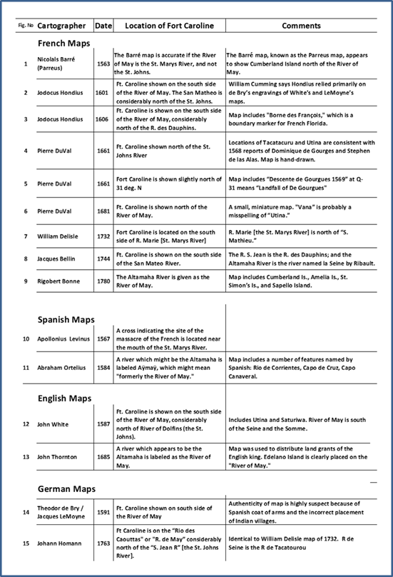
Table 1 Location of Fort Caroline in 15 Early Maps. It is noteworthy that none of these early maps placed Fort Caroline on the St. Johns River.
The map research here includes analysis of sixteenth to eighteenth century French maps, many unpublished and available only at the Bibliothèque nationale de France (BnF) in Paris. In addition, two 16th-century maps of Spanish Florida archived at the Newberry Library in Chicago were studied, as were two English maps archived at the BnF. Of special importance, Spanish documents relating to the raid of Dominique de Gourgues in 1568 were located in the Vatican Library in Rome. These maps were compared with modern NOAA coastal charts, and with the famous 1591 map of French Florida published in Frankfort by Theodor de Bry and attributed to Jacques Le Moyne.6 Another German map, the Atlas Geographicus Major Norimbergae Homannianis heredibus (1763) by Johann Baptist Homann was consulted, as was the book History of Florida Through New World Maps: Borders of Paradise of the University of Florida. Riverine areas depicted in these maps were examined by the FCAP during archaeological fieldwork, 2013-2017. Various archaeological techniques including ground penetrating magnetometry, underwater archaeology, and test-pit excavations were used; drone-mounted LIDAR investigations are planned for 2022.
Previous Map Studies
The FCAP conducted an exhaustive study of research related to Fort Caroline, and the References section below lists numerous publications that provide valuable information about the fort. However, other than studies by Spring, Crowe,7 and Fred Cook affiliated with the FCAP,8 none of the scholarly studies published to date even mentions the possibility that the fort might not be located along the St. Johns, and none makes any effort at all to consult sixteenth to eighteenth mapmakers to determine where Fort Caroline was located on those maps.
Studies of early maps of the colonial southeast do not include a search for Fort Caroline. These studies include: Karrow in 1993;9 History of Florida Through New World Maps by Dana Ste. Claire and Peter A. Cowdrey (eds.) in 2017; and Laudonnière and Fort Caroline by Charles Bennett in 2001. Likewise the article “Searching for Fort Caroline: New Perspectives” by Rebecca Douberly-Gorman in 2013,10 the Harvard University Master's thesis by Michael Fleck entitled “The Archaeological History of the Sixteenth-Century French Fort Caroline in Northeast Florida” in 2017,11 and the article “Proposed Location of the 1565 Huguenot Fort LeCaroline, Florida” by Paul H. Gissendaner included no consideration that Fort Caroline could be somewhere other than on the St. Johns River.12
In 2014, a presentation at the Southeastern Archaeology Conference in Greenville, South Carolina, by Anita Spring and Fletcher Crowe entitled “Location of Fort Caroline: The Evaluation of Four Prospective Sites”9 proposed sites for Fort Caroline not on the St. Johns; and a publication by Fred Cook in 2015, entitled “A Possible Location for Sixteenth Century Fort Caroline,” suggested locations other than those on the St. Johns.8
It is significant that not one of the ancient maps examined in this study located Fort Caroline along the St. Johns River.
“Traditional proposed Site of Fort Caroline, about six miles west of the mouth of the St. Johns River, northeast of Jacksonville, at the Ft. Caroline National Memorial”.11
Precisely where the St. Johns location came from is unknown, but the earliest reference known came in 1865 in the book Pioneers of France in the New World by Francis Parkman. In the beginning of Chapter III of that book, Parkman states that in 1562 the French under Jean Ribault:
crossed the Atlantic, and on the thirtieth of April, in the latitude of twenty-nine and a half degrees, saw the long, low line where the wilderness of waves met the wilderness of woods. It was the coast of Florida. . . . On the next morning, the first of May, they found themselves off the mouth of a great river. Riding at anchor on a sunny sea, they lowered their boats, crossed the bar that obstructed the entrance, and floated on a basin of deep and sheltered water. . .They named the river the River of May. It is now the St. John's. (Francis Parkman 1996)1
This reference by Parkman implies that French records had verified that the French expedition actually visited St. Johns Bluff and built a fort there. That is incorrect. The location where Fort Caroline was to be built was first described in a report of the 1562 expedition along the southern coast of North America by Jean Ribault. This report, appearing in his book The Whole and True Discovery of Terra Florida, was published in England in 1563. It indicated that the Ribault expedition made landfall at 29½ degrees N, and then sailed north from 1:00 PM to darkness. Copies of key pages of the Ribault book as printed in 1563 are shown in Table 2. Ribault wrote that on:
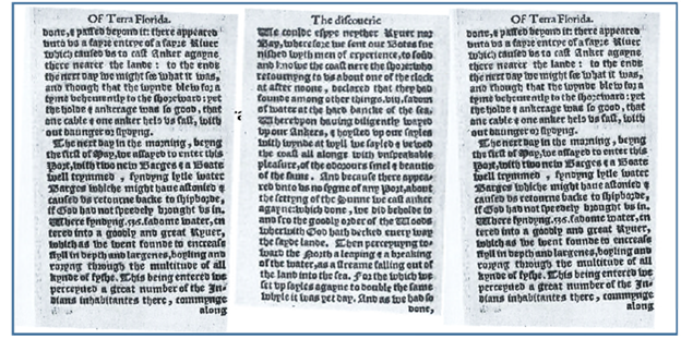
Table 2 The Discovery of the River of May in 1562. From The Whole and True Discovery of Terra Florida, ppg. 30-32, by Jean Ribault (1563)13.
Thursday the laste of Aprll at the breake of the daye, we discovered and clearely perceived a faire coast, stretchyng of a great length covered with an infinite number of high & and fayre trees, we being not past 7 or 8 leagues fro[m] the shore, the countrey seeming unto us plain, without any shewe of hilles, & approching nearer within foure or five leagues of the land, we cast an Anker at tenne fadome[s] water, the bottome the Sea beyng playne wyth muche Ocias and faste holde on the Southe syde, as farre as a certayne poynte or Cape Situate[d] under that Lattitude of nine & twenty degrees & a half, which we have named Cape Francois.13 Table 2
Nowhere does Ribault indicate that the French expedition of 1562 stopped at the St. Johns River. Moreover, neither the memoir of life in French Florida written by Jacques le Moyne nor the record of the French in Florida written by Laudonnière, called L’Histoire notable, give any indication that the French either landed at or near the St. Johns River.
Early French Maps
Nine maps by six early French cartographers (Jodocus Hondius, Pierre DuVal, Rigobert Bonne, William Delisle, Jacques Bellin, and Nicolas Barré) were examined. This section analyzes the placement of Fort Caroline and the River of May found on each of these French maps.
The Parreus Map of 1563: Figure 1 shows the so-called Parreus Map of 1563. In 1562, the Jean Ribault expedition arrived from France to explore the North American coastline and scout out sites for a new French colony. His cartographer, Nicolas Barré, carefully mapped the coast of today’s northeast Florida, Georgia, and South Carolina looking for suitable locations.
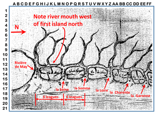
Figure 1 Parreus Map of French Florida, 1563.14 Shows a river west of the first island north of the River of May. If the River of May is the St. Marys River, this island is Cumberland Island, and the map is correct.
The resulting map of Barré was stolen by the Spanish and published the next year, 1563, as the “Parreus Map.”14 As seen in Figure 1, the mouth of the River of May is shown as being just south of a large island. The geography depicted by Barré only conforms to the coast if the River of May is the St. Marys River, and not the St. Johns River or the Altamaha River.
The Hondius Map of 1601: Figure 2 shows a map of French Florida by Jodocus Hondius published in 1601. In this map, the St. Augustine River (“Rio S Aug” on the map) is found in the accustomed location J-16. Port Royal is situated in its appropriate location at U-4, which corresponds to Parris Island, South Carolina today.

Figure 2Detail of Map of “Virginia and Florida” 1601. This map by Jodocus Hondius first appeared in Mercator’s atlas of 1601 published by Hondius. (From the map collection of C. F. Thompson).
The River of May (“R. May” on the map), however, is located considerably north of San Mateo at N-10, and the site of Fort Caroline, termed “Caroline Ruiné,” [the ruins of Fort Caroline] is located at L-9, on the “River of May”. A square symbol denoting a European fortification is situated several kilometers inland (west) of the mouth of the River of May. The coastal lowlands northeast of the ruins are labeled “CAROLINE autrefois Floride François” [“Carolina: Formerly French Florida”]. According to William P. Cumming in the book The Southeast in Early Maps,2 15 Hondius relied primarily on de Bry’s engravings of White’s and LeMoyne’s maps of Virginia and Florida, respectively.
Hondius Map of 1606: Figure 3, a map of French Florida, dated 1606, by Jocobus Hondius, places Fort Caroline, on the River of May, which is shown north of the River of Dolphins. The River of Dolphins drains a large lake, which most likely corresponds to the Okefenokee Swamp. The St. Marys River drains the Okefenokee, and hence the River of Dolphins can be considered the St. Marys. The map includes a marker labeled “Borne des François” at R-16, which means “French Boundary Marker,” a designation that appears on no other printed map found by the FCAP.
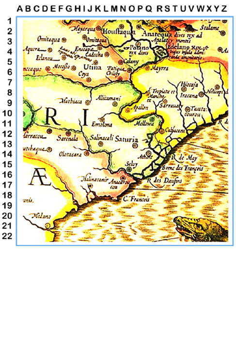
Figure 3 Map of French Florida by Jacobus Hondius, 1606. Fort Caroline is shown at R-16 on the River of May. “Borne des François” at P-16 means “French Boundary Marker.” Source: Historic Urban Plans, Inc.
This map is known as Map of VlRGINIAE Item et FLORIDAE, From Gerard Mercator and Judocus Hondius, Atlas sive Cosmographicae Meditationes de Fabrica Mundi et Fabricati Figura, 1606.3
Pierre DuVal Hand-Drawn Map, 1661: Figure 4 is a portion of an unpublished, hand-drawn map of French Florida by Frenchman Pierre DuVal, archived in the Rare Maps unit of the Richelieu library of the BnF in Paris. In this map, DuVal (1618–1683) placed Fort Caroline on the south side of the River of May, near the mouth of the river at K-14, and drew Edelano Island upstream, at L-4.
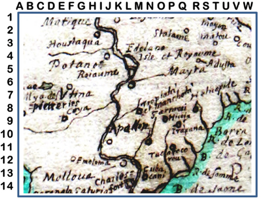
Figure 4 Pierre DuVal’s Map of French Florida (1661) shows Fort Caroline at K-14. Source: Bibliothèque national de France. The locations of Tacatacuru and Utina are consistent with 1568 reports of Dominique de Gourges and Stephen de las Alas.
This blow-up shows in detail how the cartographer has carefully drawn Edelano Island with an associated downstream islet in the River of May (L-4). This map also includes Indian villages reported by the French colonists of Fort Caroline: Malloua, Potano, Sarroui, Tacatacouru, Saturiwa, Heliocopille and Utina, but there is no notation or accompanying documentation stating from what source DuVal took this information. This map includes “Charlesfort” at L-14. There was indeed a Charlesfort, a rough shelter built in 1562 located in today’s South Carolina, but this “Charlesfort” is surrounded by Indian villages that are known to have surrounded Fort Caroline, so this “Charlesfort” could only be the Fort Caroline of 1564.4
The map also includes coastal rivers named in French by the Ribault expedition of 1562: R de Saone (the Seine), R. Somme, R. Garonne, and R. Loire.
What is significant about this map is that the placement of Tacatacuru a P-11 is wholly consistent with the location of that village as reported by Dominique de Gourgues, the French corsair who attacked the Spanish-held Fort San Mateo (the former Fort Caroline), in 1568. He reported that Tacatacuru was “walking distance” from Cumberland Island on the coast, north of the mouth of what is today the St. Marys River. In addition, the location of Utina is entirely consistent with the location of Utina as described by Stephen de las Alas, the commander of Fort San Mateo [aka Fort Caroline] in 1568 when it was attacked by Dominique de Gourgues.
The Pierre DuVal Map of 1661: A number of French maps of the seventeenth century placed Fort Caroline at or near 31 degrees N. Among these is the map of French Florida by Pierre DuVal, published in about 1661 (Figure 5). In this map, Fort Caroline is located at N-10, slightly north of 31 degrees N.
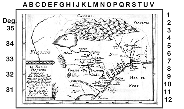
Figure 5 Map of French Florida by Pierre DuVal, c. 1661. Note that DuVal places Fort Caroline at N-10, slightly north of 31 deg. Note that “Descente de Gourgues 1569” at Q-31 means “Landing of De Gourgues,” perhaps 10 miles north of the River of May.
Pierre DuVal Map of 1681: Figure 6 shows a miniature map of la Floride francoise [French Florida] by Pierre DuVal, dated 1681. Note in this map that Fort Caroline is placed considerably north of the River of May, and the San Mateo River is placed south of the River of May. The map prominently displays “Vana” which is probably a misspelling of “Utina.”

Figure 6 Detail of Map of Florida by Pierre DuVal,c. 1681. Miniature. Note that Fort Caroline is located north of the River of May; and that the River of May is north of the San Matheo River.
The Delisle Map of 1732: A third French map that locates Fort Caroline north of the St Johns River is shown in Figure 7. This map of North America drawn by William DeLisle [Guillaume de l'Isle] in 1732 shows the “Ancien Fort des Francois” [“the Ancient French Fort”] lying near the mouth of the River of May. Fort Caroline is located far north of “S. Mathieu,” which is placed south of “S. Jean,” which represents the St. Johns River at H-9.
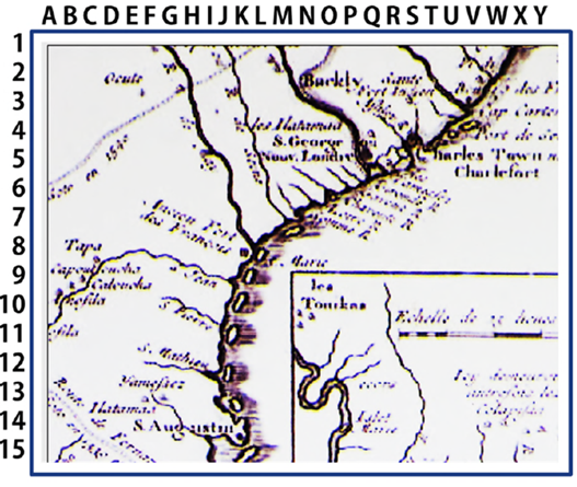
Figure 7 Map of French Florida by William DeLisle, 1732. Fort Caroline is shown considerably north of “S. Jean” [i.e., the St. Johns River], and north of Saint Augustine at J-14. Fort Caroline is shown on the south side of R. St. Marie [today’s St. Marys River] labeled as the R. de May. The River of May is north of the “St. Jean”. Source: Georgia Department of Natural Resources.
Delisle (1675–1726) was a French cartographer whose geographical knowledge led him to become the first Premier Royal Geographer of France with a fixed salary. He reformed cartography by introducing the method of using measuring scales and marking landmarks on maps. Delisle applied his training in mathematics and astronomy to develop a more scientific approach to map-making, fixing positions by astronomical data.
The Bellin Map of 1744: Figure 8 is a map of French Florida prepared by the French cartographer Jacques Bellin in 1744, 179 years after the massacre of the French at the fort. The inscription at M-7 reads “Ici fut battie la Caroline” [“Fort Caroline was constructed here”]. The inscription at H-6 reads “R. S. Matheo c’etoit la R. de May” [San Matheo River, once known as the River of May]. The inscription at R-8 reads “R. S. Augustin auj. R. S. Juan c’etoit R. des Dauphins” [The St. Augustine River, today known as the St. Johns River, was once known as the River of Dolphins]. Again, Fort Caroline was not located on the St. Johns River, but a good distance north.
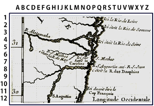
Figure 8 Map of French Florida by Jacques Bellin, 1744, showing where Fort Caroline had been located at N-6.5. Source: Bibliothèque national de France.
In this map, Bellin shows where Fort Caroline had been located at N-6.5 on the southern side of the R. S. Matheo (The Spanish had renamed the May River the “River San Matheo” after the 1565 massacre). Fort Caroline is located far north of the St. Johns River which flows from south to north at H-9, emptying into the Atlantic at P-8. The fort is placed just below 31 degrees. Rivers named by the Ribault expedition of 1562 (the Loire, the Somme and the Seine) are shown north of Fort Caroline on the Mateo/May River. The Altamaha is named as the Seine.
The Bonne Map of 1780: As seen in Figure 9, an eighteenth-century French map by Rigobert Bonne clearly identifies the Altamaha River as the River of May. This map of North America was drawn in about 1780 by Rigobert Bonne (1727―1795) who is identified on the map as the “Hydrogeographique des Indes Orientales” [Geographer of the West Indies] for the French navy.
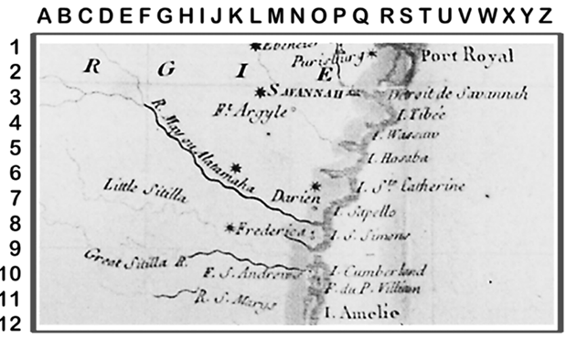
Figure 9 Detail of map of North America drawn about 1780 by French cartographer Rigobert Bonne. The map identifies the “Altamaha” River as the River of May at J-5. Note that the River of May is a good deal north of “R. S. Marys.” Map from the collection of C. F. Thompson.
Early Spanish Maps
In addition to the ten French maps that show Fort Caroline north of the St. Johns River, two Spanish maps suggest this interpretation as well: the Levinus map of 1567 and the Ortelius map of 1584.
The Levinus Map of 1567: Figure 10 shows a map by Apollonius Levinus, published in 1567, only two years after the massacre of the French at Fort Caroline. The arrow points to the marker at G-11 indicating where Fort San Matheo (formerly Fort Caroline) was located. This map was produced when the Spanish were occupying “Fort San Matheo,” the renamed Fort Caroline and was published 24 years before the le Moyne/De Bry map of 1591. The cross marking the fort is located in what would later become southeast Georgia, not far from the mouth of the St. Marys River, and definitely not on the St. Johns River.
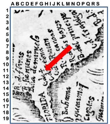
Figure 10 Map of Spanish Florida by Apollonius Levinus of 1567. This map was published in Spain two years after the massacre of the French at Fort Caroline. The arrow points to the marker at G-11 indicating where Fort San Matheo (formerly Fort Caroline) was located. “C de +” is an abbreviation meaning “Cape of Death” or “Cape of Massacre.” Courtesy of the Newberry Library, Chicago, IL.
The Ortelius Map of 1584: Figure 11 shows a map of Spanish Florida by Abraham Ortelius which appeared in the Spanish atlas Theatrum Orbis Terrarum, published in 1584. That year was 19 years after the massacre of the French, and 7 years before the le Moyne map of French Florida was published in 1591. In this map, the course of the Rio Sero is similar to that of the Altamaha, and next to that river is the label “Aÿmaÿ.” “Ayer” in Spanish means “yesterday”, and the construction Aÿ was used in Spanish colonial documents to mean “formerly” or “previously.” This term can be translated as “Previously Known as the River of May.”
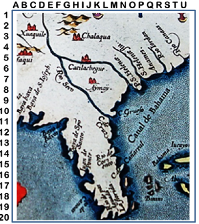
Figure 11 Map of Spanish Florida by Abraham Ortelius in the Atlas Theatrum Orbis Terrarum, 1584. Note the label at K-8 reading “Aÿmaÿ.” The Spanish word “ayer” means “yesterday,” so the term “Aÿmaÿ” may mean “formerly the river of May.
It should be noted that both of these Spanish maps show the River of May originating far to the northwest of its mouth and then flowing southeast into the ocean on the coast. By contrast, the St. Johns River originates in East-Central Florida and flows north through Lake George to Jacksonville, where it bends sharply to the east and empties into the sea at Mayport. The French and Spanish colonists knew that the River of May originated in the west and flowed southeast to the sea, which is precisely the route of both the St Marys River and Oconee-Altamaha river system.
Early English Maps
Two early English maps show the location of Fort Caroline: the 1587 map of the French Florida by Englishman John White; and a 1685 map of southeast North America by John Thornton.
The John White Map of 1587: Further clues for the location of Fort Caroline come from John White’s 1587 map of French Florida (Figure 12). White was the artist and mapmaker for the first expedition to found an English colony in Virginia, and then served as governor of the second attempt to found Roanoke Colony in 1587. It is known that he conferred with Jacques Le Moyne in London before sailing in 1587, so the map of French Florida that he drew (Figure 12) may be considered relatively accurate. John White’s map clearly shows the St. Johns River, with its prominent bend to the south, as the River des Daufins (River of Dolphins), which the French wrote was 17 miles north of 30 degrees. Fort Caroline is depicted as on the south side of the Spanish-named “Mateo Rio”, which is shown as “R. de May.”

Figure 12 Detail of Southern Portion of Map of North America by John White, 1587. Note that the "R. des Daufins," with its sharp bend to the south, is clearly the St. Johns River.
The John Thornton Map of 1685: By contrast, Figure 13, the southernmost section of a 1685 map entitled “A New Map of Carolina” drawn by John Thornton et al., shows the River of May and Edelano Island. This map was laid out using reliable surveying equipment. It provides the route of the River of May that closely matches the route of the Altamaha River. The FCAP investigated this river and concluded that the Altamaha was not the River of May.

Figure 13 The Southernmost region of “A New Map of Carolina” by John Thornton, Robert Morden, and Philip Lea, 1685. Note: the mouth of the River of May at H-13. Source: Bibliothèque nationale de France.
This 1685 English map, archived in the Rare Maps collection of the Richelieu library of the Bibliothèque nationale de France (BnF) in Paris, was prepared for sales of land to English landowners along the Cooper and Ashley rivers in today’s South Carolina. After the end of the English Civil War (1642–1651), the demise of Oliver Cromwell, and the restoration of Charles II as monarch of English in 1660, the king owed a great deal to those who assisted in bringing him to power and used this map to designate the locations of land-grants.
Early German Maps
This study examines two maps of early Florida published in German-speaking lands: the famous map of French Florida published by engraver Theodore DeBry in 1591 who reportedly used the famous French map by Jacques LeMoyne, and the Johann Homann map of 1763.
The de Bry/LeMoyne Map of 1591: Figure 14 shows the sixteenth century’s most famous and well-known of the maps considered here. It was attributed to Jacques Le Moyne who had been at Fort Caroline but was dead by 1591. Theodore de Bry was an engraver, goldsmith, editor, and publisher, famous for his depictions of early European expeditions to the Americas. He was from Liège (today’s Belgium), but published the map in Frankfurt, Germany.
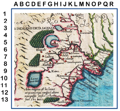
Figure 14 The Famous Map of French Florida Published by Theodor de Bry in 1591 but Attributed to Jacque Le Moyne. The locations of Indian villages do not match the locations provided by other independent French and Spanish sources. Fort Caroline is placed at N-8.
The map raises issues because it contains a number of place names known only to Spanish authorities. Moreover, according to the Royal Herald of England (data obtained by Fletcher Crowe in 2014), this French map includes the coat of arms of the Spanish King Philip II.5 “Philip, the Catholic King of Spain”, was hated by the French, since his forces under Menendez massacred the French at Fort Caroline. In addition, the placements of Indian villages on this map do not correspond with their locations found in other independent Spanish and French sources, not discussed here.
Nevertheless, the map in Figure 14, does show the area of “French Florida” [i.e., today’s southeast Georgia and northeast Florida] with Fort Caroline on the south side of the River of May.
The Johann Homann Map of 1763: Figure 15 shows a detail of the southeast coast of North America as displayed in the Map of Amplissimae Regionis of Mississippi by Johann Baptist Homann (1663-1724), published in Nuremberg in 1763 in the Atlas Geographicus Major.6 As Geographer to the Kaiser and member of the Prussian Royal Academy of Science, Homann became the first German map engraver to become a major publisher of large atlases and was regarded as the best German cartographer of his day. See: Dana Ste, Claire, Peter, A. Cowdrey, editors. History of Florida through New World Maps: Borders of Paradise. Gainesville: Library Press of Florida, 2017.16
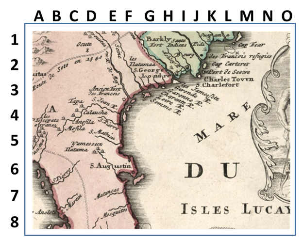
Figure 15 Detail of Map of French Florida by Johann Baptist Homann, published in 1763, Note that Fort Caroline is placed at F-3.5. Source: Library of Congress: https://www.loc.gov/resource/g4010.ar167300/?r=0.561,0.472,0.135,0.053,0.
At the top center of Figure 15 on the Atlantic coast are several rivers above present-day Florida whose French names are those on the Mercator Hondius map of 1607 named by the Ribault expedition of 1562: the Somme, the Loire, the Charente, the Garonne, and the Gironde. Compare this map with DeLisle’s map of Florida, Figure 6 above.
1Francis Parkman. 1996. Pioneers of France in the New World Paperback reprint. Pittsburg PA: Bison Books.
2William P. Cumming. 1958. The Southeast in Early Maps. Princeton University Press.15
3Dana Ste. Claire and Peter A. Cowdrey (eds.). 2017. History of Florida Through New World Maps: Borders of Paradise. Gainesville: Library Press of Florida .16 This book contains early maps of Florida that have not been included in this study because their resolution is low so it is not possible to determine if Fort Caroline appears on those maps.
4Both Fort Caroline and Charlesfort are named for Charles IX, King of France from 1560 until his death in 1574. He ascended the throne at the age of ten upon the death of his brother Francis II in 1560, and his mother the notorious Italian Catherine de' Medici, served as regent.
5 This was confirmed by the Royal Herald of England in reference to Fletcher Crowe’s research question in 2014 asking why a Spanish coat of arms graced a French map.
6See Dana Ste. Claire and Peter A. Cowdrey (eds). 2017. History of Florida Through New World Maps: Borders of Paradise. Library Press of UF, 2017.16
This study has examined fifteen early maps of the sixteenth, seventeenth and eighteenth centuries to determine the location of Fort Caroline. While conventional wisdom has maintained for at least 150 years that Fort Caroline was located on the south side of the St. Johns River northeast of today’s city of Jacksonville, not one of these maps places Fort Caroline on the St. Johns.
The putative location of the fort along the St. Johns River has been strongly affected by the map of French Florida published by Theodor de Bry in 1591 and attributed to Jacques Le Moyne. However, the FCAP is highly suspect of this map because it features of coat of arms of Philip II, the king of Spain whose soldiers massacred the French at Fort Caroline, and because the locations of certain Indian villages near the fort are clearly incorrect.
This study has concluded that the first two earliest maps – the John White map of 1587 and the Barré/Parreus map of 1563 – can be used with confidence. One way to determine the location of Fort Caroline is to triangulate the fort’s position using known locations for surrounding Indian villages, such as Tacatacuru and Utina. The account of the attack on the fort written by Dominque de Gourgues in 1569 gives considerable information about the location of Tacatacuru; and the report written by Stephen de las Alas (found in the Vatican Library), the commander of Fort San Mateo (aka Fort Caroline) following the de Gourgues raid, gives valuable information on the location of Utina. Furthermore, an unpublished hand-drawn map of French Florida by Pierre DuVal of 1661 archived in the Bibliotèque nationale de France, incorporates both sources.17-19
The FCAP wishes to express its appreciation to the Felburn Foundation for research support
Authors declare that there are no conflicts of interest
The Felburn Foundation

©2022 Crowe, et al. This is an open access article distributed under the terms of the, which permits unrestricted use, distribution, and build upon your work non-commercially.